Peaked at 882 in 1980; 654 people lived here in 2020.
17 censuses, 1860–2020.
U.S. Census Bureau decennial counts, from the census table on Saybrook’s Wikipedia page.
Every building
Saybrook, building by building, 1893–1913
Fire insurance maps drew every building, what it was made of and what it was used for, so insurers could price the risk of fire. Pick a year, then a sheet.
1893Sheet 1 of 1
Edition
Sheets
BrickWoodStone
Sanborn Map Company, via the Library of Congress. Editions published in 1930 or earlier, which are in the public domain.
Saybrook was laid out March 4, 1856, by Isaac M. Polk (c.1814–?). Little is known about Polk as he was born in Indiana and did not live in McLean County for very long. In 1860 and 1870, he was in neighboring Livingston County.
Passages that mention Saybrook, cut from the printed page as they were published.
History of McLean County, Illinois1924 · page 89Read the page →
Read the text
decided to build his home at another grove to the north and east. This grove of 3,000 acres of timber ever after took the name of Cheney, and his home became the center of the new settlement which grew into a township and the town of Saybrook. The grove is located at the headwaters of the Sangamon river, which flows through it and makes a delightful place in pioneer times or the present. Until about the year 1829, the Cheneys were the only settlers at this grove, but in the latter year
Text read by machine from the scan; it may contain errors.
History of McLean County, Illinois1924 · page 90Read the page →
Read the text
ing, it suffered from hard rains. The settlers in the early years had to go long distances for their milling and supplies, to Bloomington or Mackinawtown, or eastward to the Wabash river, since most of the mills of the time were run by water. A village called Saybrook was established, but it had a very slow growth in the first years, until after the railroad was built in 1871. Robert Cunningham built a grist mill and a saw mill on the banks of Sangamon, but the flow of water was uncertain. In 1850 he changed to steam power. The postoffice which was established in
Text read by machine from the scan; it may contain errors.
Scans and text from the Internet Archive. Books published in 1930 or earlier, which are in the public domain.
Timeline
Saybrook, 1831 to 1980
Woven from the archive, old maps, post office records, the National Register and the people born here.
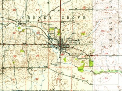
Every edition of the U.S. Geological Survey’s map of Saybrook. Tap a year, or press play to watch the town change.
1952Arrowsmith sheet · 1:62,500
U.S. Geological Survey historical topographic maps (public domain), via Esri’s collection of the scans. The red ring marks the center of Saybrook.
Places that used to be
Lost post offices and burying grounds
Saybrook’s post office has been open since 1865. Another post office, Cheney Grove, opened and closed inside today’s town.
Cheney Grove
1831–1865
Saybrook
1865–today
18301930today
2cemeteries and burying grounds inside Saybrook
Cheney Grove TownshipTownship
US Post Offices dataset (Blevins & Helbock, CC0). Places and cemeteries from the USGS Geographic Names Information System (2021).
Questions about Saybrook’s history
What year was Saybrook founded?
In 1856, according to Wikidata and Wikipedia’s history of the town. Saybrook’s post office opened in 1831, and the census of 1860 counted 69 people here.
Founding dates: Wikidata, Wikipedia, the U.S. post office records of Blevins & Helbock (CC0) and the Census. Homes by year built: Census ACS 2020–24. National Register of Historic Places: National Park Service (list of May 22, 2026). Old photos, postcards and papers: Wikimedia Commons, the Library of Congress and other public archives, credited on each item’s page. Maps: U.S. Geological Survey historical topographic maps (via Esri) and Sanborn fire-insurance maps (Library of Congress). History text and census tables: Wikipedia (CC BY-SA 4.0). Places that used to be: USGS Geographic Names Information System (2021). How TownRatings grades history →
From Wikimedia Commons (1), Wikipedia, U.S. Geological Survey historical maps, U.S. Census counts (via Wikipedia), the US Post Offices dataset (Blevins & Helbock), the USGS Geographic Names Information System, Sanborn fire insurance maps (Library of Congress) and old county and town histories (Internet Archive). Archive images are copied here with their credits and licenses, shown on each photo’s page. Refreshed monthly.


 Date?

