Oswego dates to 1833, and 1 of its places is on the National Register
More historic than 65% of U.S. towns · #295 of 768 in Illinois. What drives it
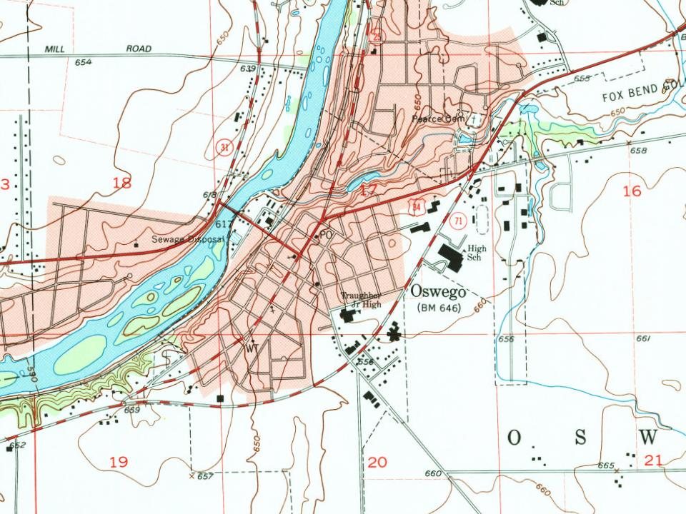
Most of Oswego was built recently: 3% of its homes predate 1940 and the median home dates from 2002. 1 place in town is on the National Register, among them a historic district with 16 buildings. Below: maps from 1885 on and the census since 1880.
Founding year: Wikidata. First post office: 1837.The full story ↓
History grade
What drives Oswego’s History grade
On its age, its old homes and the National Register, Oswego is more historic than 65% of U.S. towns, #295 of 768 in Illinois. Its National Register listings hold the grade up; its share of homes from before 1940 pulls it down.
B
HistoryA character grade: shown, never part of Oswego’s overall grade.
Few Illinois towns list much on the Register (a typical Illinois town has 0.5 per 10,000 residents, the U.S. 2.4), so Oswego’s 4.4 sits above most of its state (74% of Illinois towns have fewer) while its 16 historic buildings outnumber those of 78% of U.S. towns.
How sure. Graded on any two of the three inputs instead, the letter would range from B− to A−. The pre-1940 share (±1.3 points) is firm at this size. Two sources give 1833.
Founding year: Wikidata (other dates in Quick answers). Homes: Census ACS 2020–24. National Register: National Park Service, May 2026 list; each listing counted once (boundary changes and added documentation belong to their listing), and a historic district counts its contributing buildings. How TownRatings grades history →
What stands out about Oswego’s past
Read from the archive, the National Register and the record. The page puts what stands out first.
Lost post offices, old corners, places now gone and burying grounds
Oswego’s post office has been open since 1838. Another post office, Lodi, opened and closed inside today’s town.
Lodi
1837–1838
Oswego
1838–today
18301930today
Hamlets and corners on the map
Arbor GateAshcroftAshcroft PlaceBlackberry KnollBrighton MeadowsBrookside ManorCedar GlenDeerpath CreekDeerpath TrailsEstates Of Fox ChaseFarmington LakesFox ChaseGates CreekGates Creek WestLakeview EstatesLakeview Estates WestMill Race CreekMorgan CrossingOld Reserve HillsOswego Village SquarePark PlacePonds At Mill Race CreekRiver Mist On The FoxRiver Run
Gone or out of use
Cutler SchoolschoolFlying M Farm AirportairportHarvey SchoolschoolRussell SchoolschoolSquires Schoolschool
1cemetery inside Oswego
Pearce
US Post Offices dataset (Blevins & Helbock, CC0). Places and cemeteries from the USGS Geographic Names Information System (2021).
Help out
Start Oswego’s collection
The first neighbors to add old photos shape how Oswego’s history is told.
Decades since 1900 with photos
00s10s20s30s40s50s60s70s80s90s
0 of 10 decades. The empty ones are waiting for someone’s album.
Fire insurance maps drew every building, what it was made of and what it was used for, so insurers could price the risk of fire. Pick a year, then a sheet.
In 1833, William Smith Wilson, his wife Rebecca, and his brother-in-law Daniel Pearce moved to the area now known as Oswego. The land belonged to the local Potawatomi, Ottawa, and Chippewa tribes, but the United States government removed the Native Americans when the government started surveying the land along the Fox River in Kendall County. In 1842, the federal government placed the land for sale at an established price of $1.25 an acre.
Passages that mention Oswego, cut from the printed page as they were published.
History of Kendall county, Illinois, from the earliest discoveries to the present time1877 · page 374Read the page →
Read the text
The opening of THE YEAR 1868 was signalized by another great freshet. The Oswego bridge was damaged, the Bristol bridge damaged, and Black's dam partially washed out, at a loss of two thousand dollars. Post's bridge was entirely carried away, and three spans of the new Millington bridge were taken. This introduced the year that seemed to be
Text read by machine from the scan; it may contain errors.
History of Kendall county, Illinois, from the earliest discoveries to the present time1877 · page 231Read the page →
Read the text
of D. H. Shonts, Esq. : Three miles above Piano, on the Big Rock creek, is the mill site where in 1836 a saw mill was erected by Elisha Pearce and Wm. Wilson, of Oswego. They also got out the frame for a grist mill, but it was never put up. In 1838 the property was traded to Eber M. Shonts, and in 1842 to his brother, David H. Shonts, the present owner. The latter came with his family from Herkimer county, New York, with
Text read by machine from the scan; it may contain errors.
Scans and text from the Internet Archive. Books published in 1930 or earlier, which are in the public domain.
Timeline
Oswego, 1833 to 1987
Woven from the archive, old maps, post office records, the National Register and the people born here.
In 1833, according to Wikidata. Oswego’s post office opened in 1837, and the census of 1880 counted 663 people here.
How does Oswego rank for history?
Oswego is more historic than 65% of U.S. towns, #295 of 768 in Illinois. The History grade combines the town’s founding era, the share of homes built before 1940 and its National Register listings. It’s a character grade, so it isn’t part of the overall grade. How it works.
What is on the National Register in Oswego?
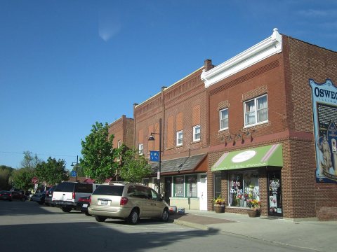
One place: the Downtown Oswego Historic District (listed 2022).
How old are the homes in Oswego?
3% of Oswego’s homes were built before 1940 (Census estimate, ±1.3 points), against a typical 11% for an Illinois town; the median home was built in 2002.
Founding dates: Wikidata, Wikipedia, the U.S. post office records of Blevins & Helbock (CC0) and the Census. Homes by year built: Census ACS 2020–24. National Register of Historic Places: National Park Service (list of May 22, 2026). Old photos, postcards and papers: Wikimedia Commons, the Library of Congress and other public archives, credited on each item’s page. Maps: U.S. Geological Survey historical topographic maps (via Esri) and Sanborn fire-insurance maps (Library of Congress). History text and census tables: Wikipedia (CC BY-SA 4.0). Places that used to be: USGS Geographic Names Information System (2021).
From Wikimedia Commons (18), the National Register of Historic Places (1), Wikipedia, Wikidata and Wikipedia for famous people, U.S. Geological Survey historical maps, U.S. Census counts (via Wikipedia), the US Post Offices dataset (Blevins & Helbock), the USGS Geographic Names Information System, Sanborn fire insurance maps (Library of Congress) and old county and town histories (Internet Archive). Archive images are copied here with their credits and licenses, shown on each photo’s page. Refreshed monthly.



 2019
 2016
 2012
 2012
 2012
 2012
 2012
 2012
 2008
 2008
 2008
 2008
 2008
 2008
 2008
 2008
 2008
 2003