Oregon dates to 1833, and 37% of its homes were built before 1940
More historic than 96% of U.S. towns · #22 of 768 in Illinois. What drives it
4 places in town are on the National Register, among them a historic district with 44 buildings. Below: 5 old photos and papers, maps from 1893 on, and the census since 1880.
Founding year: Wikidata. First post office: 1843.The full story ↓
History grade
What drives Oregon’s History grade
On its age, its old homes and the National Register, Oregon is more historic than 96% of U.S. towns, #22 of 768 in Illinois. All 3 inputs are above most U.S. towns; its share of homes from before 1940 ranks highest and its age lowest.
A+
HistoryA character grade: shown, never part of Oregon’s overall grade.
Few Illinois towns list much on the Register (a typical Illinois town has 0.5 per 10,000 residents, the U.S. 2.4), so Oregon’s 125 sits above most of its state (95% of Illinois towns have fewer) while its 48 historic buildings outnumber those of 85% of U.S. towns.
How sure. Graded on any two of the three inputs instead, the letter would range from A to A+. The pre-1940 share is a Census survey estimate (±7.4 points). Two sources give 1833.
Founding year: Wikidata (other dates in Quick answers). Homes: Census ACS 2020–24. National Register: National Park Service, May 2026 list; each listing counted once (boundary changes and added documentation belong to their listing), and a historic district counts its contributing buildings. How TownRatings grades history →
What stands out about Oregon’s past
Read from the archive, the National Register and the record. The page puts what stands out first.
The land Oregon, Illinois was founded on was previously held by the Potawatomi and Winnebago Indian tribes. In fact, later, settlers discovered that the area contained a large number of Indian mounds, most 10–12 feet (3.0–3.7 m) in diameter.
Passages that mention Oregon, cut from the printed page as they were published.
The history of Ogle County, Illinois, containing a history of the county, its cities, towns, etc., a biographical directory of its citizens, war record of its volunteers in the late rebellion, general and local statistics ... history of the Northwest, his1878 · page 432Read the page →
Read the text
During all these years, however, notwithstanding Oregon and other towns had repeatedly voted aid, the company had accomplished nothing toward the construction of the road. The nearest railroad point to Oregon, the county seat, was at Franklin Grrove, Lee County, on the (Chicago & ]N'orthwestern Railroad, twelve miles away. The Ogle and Carroll County Railroad Company had a contract with the old Galena and Chicago Union Railroad Company by which a junction of the two roads was contemplated at Lane (now Rochelle), and this contract provided certain drawbacks on
Text read by machine from the scan; it may contain errors.
was incorporated in 1857 by the General Assembly of Illinois. Section two authorized the company to " locate, construct and complete, maintain and operate a railroad from the town of Lane (now Rochelle), in the county of Ogle, to the town of Oregon in same county: from thence to the town of Mount Morris: from thence on the most eligible and direct route to or near the town of Mt. Carroll, in the county of Carroll; from thence to the Mississippi river." The company was also empowered to construct said railroad east from Oregon to the city of Chicago. The capital stock was
Text read by machine from the scan; it may contain errors.
The history of Ogle County, Illinois, containing a history of the county, its cities, towns, etc., a biographical directory of its citizens, war record of its volunteers in the late rebellion, general and local statistics ... history of the Northwest, his1878 · page 383Read the page →
Read the text
Previous to this, however, the committee of the board of supervisors and the commissioners of highways, of the Town of Oregon, held a meeting in the county clerk's office on the 26th day of February, 1867, for the purpose of adopting a plan for the bridge, receiving proposals and letting the contract tor the construction thereof. The bridge was to be a new superstructure of the Howe truss pattern, erected on the piers of the old bridge. Proposals were received from S. M. Town, Elias Etnyre and Messrs. Cauda & Hinckley. The contract was awarded to Cauda & Hinck-
Text read by machine from the scan; it may contain errors.
Scans and text from the Internet Archive. Books published in 1930 or earlier, which are in the public domain.
By decade
Oregon, decade by decade
2 decades in the archive, from the 1900s to the 1910s. Scroll each row; tap a photo for its story.
Nothing in the archives for these yearsWeddings on Main Street, storms, parades, school pictures, the old store. If it’s in your family album, it belongs here.
In 1833, according to Wikidata. Oregon’s post office opened in 1843, and the census of 1880 counted 1,088 people here.
How does Oregon rank for history?
Oregon is more historic than 96% of U.S. towns, #22 of 768 in Illinois. The History grade combines the town’s founding era, the share of homes built before 1940 and its National Register listings. It’s a character grade, so it isn’t part of the overall grade. How it works.
What is on the National Register in Oregon?
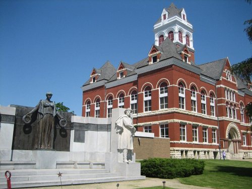
4 listings: 3 buildings, among them the Pinehill (listed 1978, the first), and 1 historic district, the Oregon Commercial Historic District, with 44 contributing buildings. 48 historic buildings in all.
How old are the homes in Oregon?
37% of Oregon’s homes were built before 1940 (Census estimate, ±7.4 points), against a typical 11% for an Illinois town; the median home was built in 1955.
Founding dates: Wikidata, Wikipedia, the U.S. post office records of Blevins & Helbock (CC0) and the Census. Homes by year built: Census ACS 2020–24. National Register of Historic Places: National Park Service (list of May 22, 2026). Old photos, postcards and papers: Wikimedia Commons, the Library of Congress and other public archives, credited on each item’s page. Maps: U.S. Geological Survey historical topographic maps (via Esri) and Sanborn fire-insurance maps (Library of Congress). History text and census tables: Wikipedia (CC BY-SA 4.0). Places that used to be: USGS Geographic Names Information System (2021).
From Wikimedia Commons (1), the Library of Congress (4), Wikidata (1), the National Register of Historic Places (4), Wikipedia, Wikidata and Wikipedia for famous people, U.S. Geological Survey historical maps, U.S. Census counts (via Wikipedia), the US Post Offices dataset (Blevins & Helbock), the USGS Geographic Names Information System, Sanborn fire insurance maps (Library of Congress) and old county and town histories (Internet Archive). Archive images are copied here with their credits and licenses, shown on each photo’s page. Refreshed monthly.




![During all these years, however, notwithstanding Oregon and other towns had repeatedly voted aid, the company had accomplished nothing toward the construction of the road. The nearest railroad point to Oregon, the county seat, was at Franklin Grrove, Lee County, on the (Chicago & ]N'orthwestern Rai…](https://images.townratings.com/story/3970/bk-44fb4511ec88987f-l.jpg)


 1904
 1904
 1912


