4 places in town are on the National Register, among them a historic district with 658 buildings. Below: 27 old photos and papers, maps from 1885 on, and the census since 1850.
Founding year: Wikidata. First post office: 1839.The full story ↓
History grade
What drives Cairo’s History grade
On its age, its old homes and the National Register, Cairo is more historic than 98% of U.S. towns. All 3 inputs are above most U.S. towns; its National Register listings ranks highest and its age lowest.
A+
HistoryA character grade: shown, never part of Cairo’s overall grade.
Few Illinois towns list much on the Register (a typical Illinois town has 0.5 per 10,000 residents, the U.S. 2.4), so Cairo’s 3,924 sits above most of its state (100% of Illinois towns have fewer) while its 660 historic buildings outnumber those of 98% of U.S. towns.
How sure. Graded on any two of the three inputs instead, the letter would range from A to A+. The pre-1940 share is a Census survey estimate (±8.9 points). Two sources give 1818.
Founding year: Wikidata (other dates in Quick answers). Homes: Census ACS 2020–24. National Register: National Park Service, May 2026 list; each listing counted once (boundary changes and added documentation belong to their listing), and a historic district counts its contributing buildings. How TownRatings grades history →
What stands out about Cairo’s past
Read from the archive, the National Register and the record. The page puts what stands out first.
Nothing in the archives for these yearsWeddings on Main Street, storms, parades, school pictures, the old store. If it’s in your family album, it belongs here.
Fire insurance maps drew every building, what it was made of and what it was used for, so insurers could price the risk of fire. Pick a year, then a sheet.
Cairo was named after the Egyptian city of the same name because its location at the confluence of the Ohio and Mississippi Rivers was reminiscent of the Nile Delta.
The first municipal charter for Cairo and the Bank of Cairo were issued in 1818, but without any settlement and without any depositors. A second and successful effort to establish a town was made by the Cairo City and Canal Company in 1836–37, with a large levee built to encircle the site. However, this effort collapsed in 1840, with few settlers remaining.
Passages that mention Cairo, cut from the printed page as they were published.
A history of the city of Cairo, Illinois1910 · page 290Read the page →
Read the text
Cairo City Property, 49, 58 Cairo City Property, Organization of Trust, 59 Cairo City Times, 220, 229, 266 Cairo Daily Argus, 163, 164 Cairo Daily News, 76 Cairo Delta, The, 59, 74. 168, 252 Cairo Drainage District, 263
Text read by machine from the scan; it may contain errors.
A history of the city of Cairo, Illinois1910 · page 221Read the page →
Read the text
The road was finished to Columbus, Kentucky, twenty miles south of Cairo, two or three or more years after the Central was finished to Cairo. The congressional land grant of September 20, 1850, was to aid in building a railroad from Chicago to Mobile, and these two railroad companies, the Central and the Mobile & Ohio, were to receive and did receive the benefits of that act; and there was, therefore, some two or three years before the Civil War a railroad from Chicago to Mobile, with the exception of the gap of twenty miles between Cairo
Text read by machine from the scan; it may contain errors.
Scans and text from the Internet Archive. Books published in 1930 or earlier, which are in the public domain.
Timeline
Cairo, 1818 to 1954
Woven from the archive, old maps, post office records, the National Register and the people born here.
Church of GodchurchDouglas Public SchoolschoolLincoln SchoolschoolMartin Temple Christian Methodist Episcopal ChurchchurchMount Union Baptist ChurchchurchSaint Joseph SchoolschoolSaint Josephs Roman Catholic ChurchchurchSecond Free Baptist Churchchurch
1cemetery inside Cairo
Green Lawn Memorial Gardens
US Post Offices dataset (Blevins & Helbock, CC0). Places and cemeteries from the USGS Geographic Names Information System (2021).
Help out
Finish Cairo’s story
Most archives stop around 1920. The photos from after that are in family albums, not libraries.
Decades since 1900 with photos
00s10s20s30s40s50s60s70s80s90s
2 of 10 decades. The empty ones are waiting for someone’s album.
In 1818, according to Wikidata. Cairo’s post office opened in 1839, and the census of 1850 counted 242 people here.
How does Cairo rank for history?
Cairo is more historic than 98% of U.S. towns. The History grade combines the town’s founding era, the share of homes built before 1940 and its National Register listings. It’s a character grade, so it isn’t part of the overall grade. How it works.
What is on the National Register in Cairo?
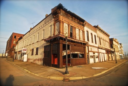
4 listings: 3 buildings, among them the Magnolia Manor (listed 1969, the first), and 1 historic district, the Cairo Historic District, with 658 contributing buildings. 660 historic buildings in all.
How old are the homes in Cairo?
40% of Cairo’s homes were built before 1940 (Census estimate, ±8.9 points), against a typical 11% for an Illinois town; the median home was built in 1953.
Founding dates: Wikidata, Wikipedia, the U.S. post office records of Blevins & Helbock (CC0) and the Census. Homes by year built: Census ACS 2020–24. National Register of Historic Places: National Park Service (list of May 22, 2026). Old photos, postcards and papers: Wikimedia Commons, the Library of Congress and other public archives, credited on each item’s page. Maps: U.S. Geological Survey historical topographic maps (via Esri) and Sanborn fire-insurance maps (Library of Congress). History text and census tables: Wikipedia (CC BY-SA 4.0). Places that used to be: USGS Geographic Names Information System (2021).
From Wikimedia Commons (12), the Library of Congress (15), the National Register of Historic Places (4), Wikipedia, Wikidata and Wikipedia for famous people, U.S. Geological Survey historical maps, U.S. Census counts (via Wikipedia), the US Post Offices dataset (Blevins & Helbock), the USGS Geographic Names Information System, Sanborn fire insurance maps (Library of Congress) and old county and town histories (Internet Archive). Archive images are copied here with their credits and licenses, shown on each photo’s page. Refreshed monthly.


 1864
 1864
 c. 1865
 c. 1865
 1889
 1896
 1900
 1907
 1909
 1909
 1909
 1911
 1911
 1913
 1913
 1913
 1913
 1913
 1913
 1913
 1913
 1913
 1913
 1913
 1913
 1913
 1913


