 Ballycanew Bridge · Photo: Michael Dibb · CC BY-SA 2.0
Ballycanew: 5 buildings on the National Inventory
Ballycanew’s oldest recorded building dates from 1700. The Sites and Monuments Record adds 3 archaeological sites inside the town.
2 photographs of Ballycanew’s heritage
First come Ballycanew Bridge and Saint Moling's Catholic Church. 2 recorded places in Ballycanew have a photo. Of the buildings pictured in Ballycanew, Ballycanew Bridge is the oldest, from 1700.
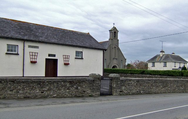
Photos from Wikimedia Commons, copied to our own server, each credited to its photographer with its licence; names open the place’s page. Tap a photo to step through them full screen.
Where Ballycanew’s history is
Every building and site on the record inside the town, by its rating.
Hover a dot for its name; tap one to open its page.
The National Inventory of Architectural Heritage is the State’s survey of buildings from 1700 to today, county by county; each record gives a rating, dates, a type and an appraisal. Being on it is not legal protection: that is each council’s Record of Protected Structures.
Points from the National Inventory of Architectural Heritage and the Sites and Monuments Record, Department of Housing, Local Government and Heritage (CC BY 4.0).
5 historic places in Ballycanew
Buildings rated Regional, of significance in their region, and archaeological monuments with an encyclopedia article.
 Reg
 Reg
In and around Ballycanew, 65% of the records are homes
There are 4 kinds of building on Ballycanew’s record. Second on the record: walls, gates and bridges, 3 of them. At the top of the record: Ballycanew Bridge and Barnadown House.
Types as the National Inventory records them, grouped, for the records inside the town and those just outside it that belong to it; a building keeps the type it was built as.
Most of Ballycanew’s dated buildings come from the 16th to 18th centuries
Each building by the first date on its record.
2 of the 5 dated ones were built before 1800. The oldest is Ballycanew Bridge, from 1700.
Archaeology in Ballycanew
The Sites and Monuments Record lists every known archaeological site; most are field monuments with little to see. By kind:
3 archaeological sites inside the town
Sites on the Record of Monuments and Places, the statutory list drawn from this record, are protected by law: anyone planning work at or near one must give the National Monuments Service two months’ notice.
| Church1 record |
| Graveyard1 record |
| Bullaun stone1 record |
Just outside Ballycanew: 12
| Barnadown HouseRegional rating (NIAH) · 2.5 km outside the town |
| Killenagh BridgeRegional rating (NIAH) · 2.3 km outside the town |
| Laurel LodgeRegional rating (NIAH) · 2.5 km outside the town |
| O'Brien'sRegional rating (NIAH) · 2.4 km outside the town |
| Neville's CourtRegional rating (NIAH) · 100 m outside the town |
| SpringmountRegional rating (NIAH) · 2.1 km outside the town |
| Raheenbeg HouseRegional rating (NIAH) · 2.4 km outside the town |
| Farm house, BallywalterbegRegional rating (NIAH) · 800 m outside the town |
| Bridge, Ballinamona (Gorey By., Ballycanew Ed), Raheen (Ballaghkeen By., Ardamine Ed)Regional rating (NIAH) · 1.5 km outside the town |
| Farm house, BrackernaghRegional rating (NIAH) · 1.7 km outside the town |
| Farm house, Ballinclare (Gorey By., Ballycanew Ed)Regional rating (NIAH) · 600 m outside the town |
| Rectory, BallycanewRegional rating (NIAH) · 100 m outside the town |
New homes are rare in Ballycanew: 2.4% since 2011, against a usual 5.8%
Building from 1981 to 2000 fell short in Ballycanew: 18%, against 24% in most towns. Before 1919: 5.3% of the homes in Ballycanew, where most towns have about 3.4%. Look at when Ballycanew’s homes went up and one period leads: in the 2000s, with 46%.
Census 2022, households by the year their home was built (CSO, Small Area Population Statistics, CC BY 4.0); the typical town is the middle Irish town of 2,500 or more.
Ballycanew and its neighbours
Ballycanew in brief
Old houses are part of Ballycanew’s character: 5.3% of its homes were built before 1919, against 3.4% in the typical town. In all there are 5 places on the record. The oldest is Ballycanew Bridge, from 1700. Otherwise the figures are ordinary: it also has 3 archaeological sites.
What this data can and can’t tell you
- The National Inventory. The State’s survey of post-1700 buildings, made county by county since 1990 (NIAH); a few records are older. It records; it does not protect.
- Ratings. International and National: of significance across Ireland or beyond. Regional: in its region. Local and record-only buildings get no page here.
- Archaeology. The Sites and Monuments Record (National Monuments Service) lists known archaeological sites; the national monuments to visit and the sites with an encyclopedia article get pages here.
- Protection. Both registers are surveys, not protection: a building is protected by its council’s Record of Protected Structures, and no national open list joins the 31 councils’ records.
- The grade. Ireland’s History grade is not built yet: the page describes, and gives no grade.
Questions about Ballycanew’s history
How many historic buildings are recorded in Ballycanew?
5 buildings on the National Inventory, from the National Inventory of Architectural Heritage.
What is the oldest building in Ballycanew?
Ballycanew Bridge: the first date on its record is 1700.
Are there archaeological sites in Ballycanew?
Yes: the Sites and Monuments Record lists 3 archaeological sites inside Ballycanew.
How old are the homes in Ballycanew?
5.3% of its homes were built before 1919, against 3.4% in the typical town.
Are the buildings on this page protected?
Being on the National Inventory or the Sites and Monuments Record is a record, not protection by itself: buildings are protected by their council’s Record of Protected Structures, which each council keeps and no national open list gathers, so this page can’t say which are on it.
History is described here, not graded.
Source: National Inventory of Architectural Heritage and Sites and Monuments Record, Department of Housing, Local Government and Heritage (CC BY 4.0); Wikidata (CC0).
Sources: National Inventory of Architectural Heritage (buildingsofireland.ie) · Sites and Monuments Record and the National Monuments Service’s monuments to visit · CSO Census 2022 (homes by the year built) · Photos: Wikimedia Commons, including the National Library of Ireland’s collections, each credited with its licence and copied to our own server · Wikidata (CC0) for other names and articles. Under Creative Commons Attribution 4.0 (CC BY 4.0).
Contains Central Statistics Office (CSO) data, Census 2022, and Tailte Éireann boundaries (CSO Urban Areas, Small Areas, local electoral areas, constituencies), under Creative Commons Attribution 4.0 (CC BY 4.0).