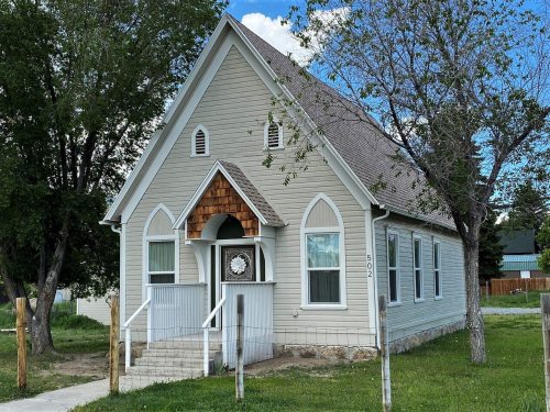
Mackay’s post office opened in 1901, and 19% of its homes were built before 1940
Its Register listings are the Mackay Episcopal Church and the Mackay Methodist Episcopal Church. Below: 1 old photo or paper, maps from 1915 on, and the census since 1910.
The Mackay post office opened in 1901, the earliest record of the town by name. Another post office, Carbonate (1884), opened inside today’s city and later closed.
First census: 638 in 19102020 census: 439125 years
Founding year: the first Mackay post office (Blevins & Helbock, CC0).
What stands out about Mackay’s past
Read from the archive, the National Register and the record. The page puts what stands out first.
Peaked at 869 in 1920; 439 people lived here in 2020.
12 censuses, 1910–2020.
U.S. Census Bureau decennial counts, from the census table on Mackay’s Wikipedia page.
The story so far
Mackay, in brief
Wikipedia doesn’t have a history of Mackay yet. The photos, dates and memories neighbors add here are how it gets written.
Mackay (pronounced ) is a town in Custer County, Idaho, United States. The population was 439 at the 2020 census. The town is pronounced "Mackie" with the accent on the first syllable.
Its first post office opened in 1901. Between the 2010 and 2020 censuses its population fell from 517 to 439 (-15%).
Intro from Wikipedia. Population: U.S. Census Bureau.
From the old history books
What they wrote about Mackay in 1900
Passages that mention Mackay, cut from the printed page as they were published.
History of Custer County, Idaho1900 · page 19Read the page →
Read the text
Meat Market, owned by C. S. Heinman; the Village Blacksmith Shop, owned by George R. Ashton. Only parts of the foundations remain now, it being deserted when the railroad came to the valley. This caused the town to be moved and the name to be changed to Mackay. The railroad came 'to Maekay in September, 1901. The traveler was awakened at dawn usually, and was hurried on his way, the next stop being at Narrows. This site is now covered by the Mackay reservoir, where parts of the foundations can yet be seen, during low
Text read by machine from the scan; it may contain errors.
History of Custer County, Idaho1900 · page 20Read the page →
Read the text
The first daily mail between Challis and May, Idaho, a small town about thirty miles from Challis, and ten miles from the mouth of the Pahsamaroi, was started on October 29. 1919. Stages still convey passengers, freight and mail from Mackay to Challis. Challis is the center of the other small towns in central Idaho, as Stanley, Foi-nej', Clayton and May. I have endeavored in this treatise to give a complete history of the County of Custer. This county, as many other small places, was settled due to the rich mining claims found in them. Here the most valued industry
Text read by machine from the scan; it may contain errors.
Scans and text from the Internet Archive. Books published in 1930 or earlier, which are in the public domain.
Timeline
Mackay, 1884 to 1940
Woven from the archive, old maps, post office records, the National Register and the people born here.
Nothing in the archives for these yearsWeddings on Main Street, storms, parades, school pictures, the old store. If it’s in your family album, it belongs here.
Every edition of the U.S. Geological Survey’s map of Mackay. Tap a year, or press play to watch the town change.
1940Mackay sheet · 1:62,500
U.S. Geological Survey historical topographic maps (public domain), via Esri’s collection of the scans. The red ring marks the center of Mackay.
Every building
Mackay, building by building, 1915–1921
Fire insurance maps drew every building, what it was made of and what it was used for, so insurers could price the risk of fire. Pick a year, then a sheet.
Founding dates: Wikidata, Wikipedia, the U.S. post office records of Blevins & Helbock (CC0) and the Census. Homes by year built: Census ACS 2020–24. National Register of Historic Places: National Park Service (list of May 22, 2026). Old photos, postcards and papers: Wikimedia Commons, the Library of Congress and other public archives, credited on each item’s page. Maps: U.S. Geological Survey historical topographic maps (via Esri) and Sanborn fire-insurance maps (Library of Congress). History text and census tables: Wikipedia (CC BY-SA 4.0). Places that used to be: USGS Geographic Names Information System (2021). How TownRatings grades history →
From Wikimedia Commons (6), the Library of Congress (1), Wikidata (1), the National Register of Historic Places (2), U.S. Geological Survey historical maps, U.S. Census counts (via Wikipedia), the US Post Offices dataset (Blevins & Helbock), the USGS Geographic Names Information System, Sanborn fire insurance maps (Library of Congress) and old county and town histories (Internet Archive). Archive images are copied here with their credits and licenses, shown on each photo’s page. Refreshed monthly.


 2013
 2013
 2013
 2013
 2012
 2004