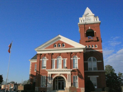
Jackson dates to 1826, and 2 of its places are on the National Register
More historic than 49% of U.S. towns · #110 of 263 in Georgia. What drives it
Most of Jackson was built recently: 3% of its homes predate 1940 and the median home dates from 1987. Its Register listings are the J. R. Carmichael House and the Butts County Courthouse. Below: 6 old photos and papers, maps from 1895 on, and the census since 1880.
Founding year: Wikidata. First post office: 1826.The full story ↓
History grade
What drives Jackson’s History grade
On its age, its old homes and the National Register, Jackson is more historic than 49% of U.S. towns, #110 of 263 in Georgia. Its age holds the grade up; its share of homes from before 1940 pulls it down.
B−
HistoryA character grade: shown, never part of Jackson’s overall grade.
Georgia towns list more on the Register than most of the country (a typical Georgia town has 10.0 per 10,000 residents, the U.S. 2.4), so Jackson’s 3.5 sits near the middle of its state (41% of Georgia towns have fewer) while its 2 listings outnumber those of 60% of U.S. towns.
How sure. Graded on any two of the three inputs instead, the letter would range from C to B+. The pre-1940 share is a Census survey estimate (±3.0 points). Two sources give 1826.
Founding year: Wikidata (other dates in Quick answers). Homes: Census ACS 2020–24. National Register: National Park Service, May 2026 list; each listing counted once (boundary changes and added documentation belong to their listing), and a historic district counts its contributing buildings. How TownRatings grades history →
What stands out about Jackson’s past
Read from the archive, the National Register and the record. The page puts what stands out first.
Lost post offices, places now gone and burying grounds
Jackson’s post office has been open since 1827. Two other post offices opened and closed inside today’s town.
Butts
1826–1827
Jackson
1827–today
Butts
1856–1859
18201920today
Gone or out of use
Church of GodchurchJackson AcademyschoolJackson Female AcademyschoolJackson Public SchoolschoolPepperton Schoolschool
1cemetery inside Jackson
Jackson City
US Post Offices dataset (Blevins & Helbock, CC0). Places and cemeteries from the USGS Geographic Names Information System (2021).
Every building
Jackson, building by building, 1895–1913
Fire insurance maps drew every building, what it was made of and what it was used for, so insurers could price the risk of fire. Pick a year, then a sheet.
Founded in 1826, Jackson began as a 303-acre (1.23 km2) plot purchased for the purpose of starting the town. The plot was divided into squares and each square into lots. The first buyer of a lot in the new town was John D. Swift of Newton County, Georgia. During the Civil War, much of Jackson was razed by the army of General William T. Sherman during his March to the Sea. After the war, Jackson, like much of the South, struggled economically for decades. Jackson remained little more than a small village until the arrival of the railroads in the latter half of the 19th century. On May 5, 1882, the first train arrived in Jackson, heralding a new era in the transportation of people and goods.
Passages that mention Jackson, cut from the printed page as they were published.
The early history of Jackson county, Georgia. "The writings of the late G.J.N. Wilson, embracing some of the early history of Jackson county". The first settlers, 17841914 · page 31Read the page →
Read the text
Sixteen years passed without any further change. In 1837 an additional part of Franklin was added to Jackson; and in 1850 a few hundred acres of Jackson were cut off to Clarke. In 1852 the line of Jackson was so changed as to include the residence of William Sanders in Madison. In 1856 the residence of Jesse Lord was transferred from Jackson to Banks, and the lands of David Smith in Gwinnett were added to Jackson. The plantation of George W. Hudson was taken from Jackson and added to
Text read by machine from the scan; it may contain errors.
The early history of Jackson county, Georgia. "The writings of the late G.J.N. Wilson, embracing some of the early history of Jackson county". The first settlers, 17841914 · page 25Read the page →
Read the text
Ten years passed away before Jackson was again called on for a division of her patrimony, by its citizens living east of Big Sandy creek. By taking a large part from Jackson, and smaller portions from Oglethorpe, Clarke, Franklin and Elbert Counties, Madison County was formed by an Act approved December 5th, 1811, and by "beginning on the Clarke County line on the ridge between Bushy and Beaverdam creek ; thence a direct line to where the Jackson County line crosses Little Sandy creek ; thence
Text read by machine from the scan; it may contain errors.
Scans and text from the Internet Archive. Books published in 1930 or earlier, which are in the public domain.
By decade
Jackson, decade by decade
One decade in the archive so far: the 1900s. Scroll each row; tap a photo for its story.
Nothing in the archives for these yearsWeddings on Main Street, storms, parades, school pictures, the old store. If it’s in your family album, it belongs here.
In 1826, according to Wikidata. Jackson’s post office opened in 1826, and the census of 1880 counted 212 people here.
How does Jackson rank for history?
Jackson is more historic than 49% of U.S. towns, #110 of 263 in Georgia. The History grade combines the town’s founding era, the share of homes built before 1940 and its National Register listings. It’s a character grade, so it isn’t part of the overall grade. How it works.
What is on the National Register in Jackson?
Two places: the J. R. Carmichael House (listed 1977) and the Butts County Courthouse (1980).
How old are the homes in Jackson?
3% of Jackson’s homes were built before 1940 (Census estimate, ±3.0 points), against a typical 3.8% for a Georgia town; the median home was built in 1987.
Founding dates: Wikidata, Wikipedia, the U.S. post office records of Blevins & Helbock (CC0) and the Census. Homes by year built: Census ACS 2020–24. National Register of Historic Places: National Park Service (list of May 22, 2026). Old photos, postcards and papers: Wikimedia Commons, the Library of Congress and other public archives, credited on each item’s page. Maps: U.S. Geological Survey historical topographic maps (via Esri) and Sanborn fire-insurance maps (Library of Congress). History text and census tables: Wikipedia (CC BY-SA 4.0). Places that used to be: USGS Geographic Names Information System (2021).
From Wikimedia Commons (5), the Library of Congress (6), the National Register of Historic Places (2), Wikipedia, Wikidata and Wikipedia for famous people, U.S. Geological Survey historical maps, U.S. Census counts (via Wikipedia), the US Post Offices dataset (Blevins & Helbock), the USGS Geographic Names Information System, Sanborn fire insurance maps (Library of Congress) and old county and town histories (Internet Archive). Archive images are copied here with their credits and licenses, shown on each photo’s page. Refreshed monthly.


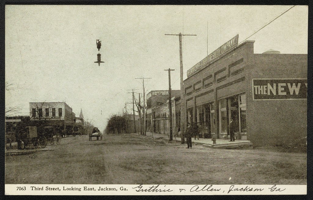


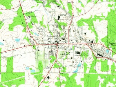


 1908
 1908
 1908
 1908
 1908
 2009
 2009
 2009
 2009
 2005