
In Saint-Mammès, Jonor is the place to visit
Around Saint-Mammès, the places to visit include 7 attractions, 5 châteaux and 4 museums. Mapped in Saint-Mammès is one place to visit, and within 5 km of its centre another 22. For a longer trip, Château de Fontainebleau lies 8.6 km away.
Saint-Mammès’ big names
Beyond Jonor, there are 2 châteaux, a museum and a fort.
 MuseumMusée de l'atelier Rosa Bonheur2.5 km northwest, in Thomery
 ChâteauChâteau de Moret1.9 km south, in Moret-Loing-et-OrvanneFortFortPorte de Paris1.5 km south, in Moret-Loing-et-OrvanneGardenGardenChemin des Longs Sillons3 km northwest, in Thomery
 ChâteauChâteau de Graville2.1 km northeast, in Vernou-la-Celle-sur-Seine
Best known first: by how many Wikipedia and sister-site articles cover each place (Wikidata’s count). It isn’t a ranking of how good they are.
Where they are
Close by, the 22 mostly lie to the south.
The first 20 on the list, numbered as below. The shape is the commune of Saint-Mammès; the orange dot is its centre. © OpenStreetMap contributors · commune boundary: IGN
The mix
The two biggest groups: châteaux or heritage sites (8) and other sights (7).
Dark: in Saint-Mammès. Light: in the communes within 5 km of its centre.
Every place to visit in and near Saint-Mammès
In town there is one, and the list adds 22 more within 5 km of its centre.
Château de Moret
Castle in Moret-sur-Loing in the Seine-et-Marne département of France.
Les Renardières
Research center for Électricité de France, located in Écuelles (Seine-et-Marne), France.
 10
The one place in Saint-Mammès, then those within 5 km of its centre.
The history of Saint-Mammès → · Parks and trails in Saint-Mammès →
Further away
Château de Fontainebleau, at 8.6 km, heads the 12.
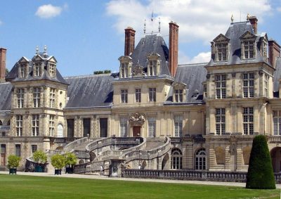 ChâteauChâteau de Fontainebleau8.6 km west, in FontainebleauAttractionAttractionChâteau de Vaux-le-Vicomte21 km north, in Maincy
 MuseumChâteau de Nemours16 km southwest, in Nemours
 CathedralCathédrale de la Résurrection d'Évry39 km northwest, in Évry-CourcouronnesChâteauChâteauChâteau de Saint-Ange de Villecerf8.2 km southeast, in VillecerfChâteauChâteauChâteau de Courances26 km west, in CourancesChâteauChâteauChâteau de Blandy-les-Tours20 km north, in BlandyCathedralCathedralCathédrale Saint-Spire de Corbeil-Essonnes35 km northwest, in Corbeil-Essonnes
 ChâteauChâteau de Bourron10 km southwest, in Bourron-Marlotte
 MuseumMusée départemental de Préhistoire d'Île-de-France16 km southwest, in NemoursAbbeyAbbeyAbbaye Royale de Ferrières33 km south, in Ferrières-en-GâtinaisChâteauChâteauChâteau de Vallery24 km southeast, in Vallery
Places within 40 km of Saint-Mammès with an article in both French and English Wikipedia, nearest first.
Seeing Saint-Mammès: your questions
What is there to see in Saint-Mammès?
The one place mapped in Saint-Mammès is Jonor. We list 1 place in town. Another 22 are within 5 km of the centre.
Are there museums in or near Saint-Mammès?
6 museums and galleries in town or within 5 km, including Musée de l'atelier Rosa Bonheur, Salle Hippolyte Bayard, Musée Municipal and Musée du vélo.
What well-known places are within a day out of Saint-Mammès?
The nearest with articles in both French and English Wikipedia: Château de Fontainebleau (8.6 km), Château de Vaux-le-Vicomte (21 km), Château de Nemours (16 km), Cathédrale de la Résurrection d'Évry (39 km).
How is this list made?
From OpenStreetMap and Wikidata: named museums, galleries, châteaux, abbeys, gardens, zoos, theme parks and other visitor attractions whose mapped point lies inside the commune of Saint-Mammès, then those in the communes within 5 km of its centre, and well-known places within 40 km. Houses, ruins and gardens need a sign they’re open to visitors; places marked private, closed or disused are left out. The historic-monument link is the Culture ministry’s Mérimée record. A place that isn’t mapped isn’t listed, so this isn’t everything there is to see.
Sources: OpenStreetMap (© OpenStreetMap contributors, ODbL), Wikidata (CC0: descriptions, websites, Wikipedia articles), the Culture ministry’s Mérimée database (Licence Ouverte 2.0), IGN commune boundaries. Distances are from the commune’s centre point.
Photos from Wikimedia Commons, each under its own licence (our copy, resized).
Photo credits (9)
- Musée de l'atelier Rosa Bonheur: Architect : unknown Photography : Teofilo, CC BY-SA 2.0, Wikimedia Commons
- Château de Moret: Reinhardhauke, CC BY-SA 3.0, Wikimedia Commons
- Château de Graville: Thor19, CC BY-SA 3.0, Wikimedia Commons
- Château de By: Architect : unknown Photography : Teofilo, CC BY-SA 2.0, Wikimedia Commons
- Château de Fontainebleau: user:Carolus, CC BY 2.5, Wikimedia Commons
- Château de Nemours: Pline, CC BY-SA 3.0, Wikimedia Commons
- Cathédrale de la Résurrection d'Évry: Pino Musi, CC BY-SA 4.0, Wikimedia Commons
- Château de Bourron: vincent6464, CC BY 3.0, Wikimedia Commons
- Musée départemental de Préhistoire d'Île-de-France: Serendipita77, CC BY-SA 3.0, Wikimedia Commons
Contains public sector information under the Licence Ouverte / Open Licence 2.0 (Etalab): INSEE, DGFiP, the Interior Ministry’s statistics service (SSMSI), the Ministry of Education (DEPP), the Health Ministry’s statistics service (DREES) and the Housing Ministry (Carte des loyers). Commune boundaries: IGN Admin Express.