
The one place to visit in Pézènes-les-Mines is Dolmen des Roudanergues
One place to visit is mapped in Pézènes-les-Mines, and 2 more within 5 km of its centre. On the list: an archaeological site, an attraction and a château, among others. A drive of 16 km brings you to Cathédrale Saint-Fulcran de Lodève.
The headline places in Pézènes-les-Mines
After Dolmen des Roudanergues come an attraction and a château.
Best known first: by how many Wikipedia and sister-site articles cover each place (Wikidata’s count). It isn’t a ranking of how good they are.
Where each one is
Le Castelas (ruines du château de Malavieille) marks the outer edge, 4.1 km away.
The first 20 on the list, numbered as below. The shape is the commune of Pézènes-les-Mines; the orange dot is its centre. © OpenStreetMap contributors · commune boundary: IGN
The kinds on offer
The biggest group is châteaux or heritage sites, with 2 of the 3.
Dark: in Pézènes-les-Mines. Light: in the communes within 5 km of its centre.
Everything to see
The town has one; within 5 km of its centre, the list finds 2 more.
The one place in Pézènes-les-Mines, then those within 5 km of its centre.
The history of Pézènes-les-Mines → · Parks and trails in Pézènes-les-Mines →
A little further out
Out of town, Cathédrale Saint-Fulcran de Lodève (16 km) leads 12 names to know.
 AttractionCathédrale Saint-Étienne d'Agde37 km southeast, in AgdeAttractionAttractionPont du Diable28 km northeast, in Aniane
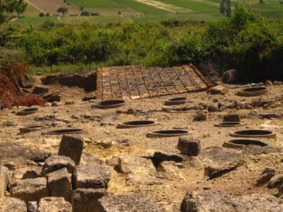 AttractionOppidum d'Ensérune34 km south, in Nissan-lez-EnseruneAttractionAttractionPrieuré Saint-Michel de Grandmont18 km northeast, in Saint-PrivatChâteauChâteauChâteau de Roquessels5.8 km south, in RoquesselsMuseumMuseumNoilly Prat36 km southeast, in MarseillanAttractionAttractionÉcluses de Fonseranes30 km south, in BéziersAbbeyAbbeyAbbaye Royale d'Aniane29 km east, in AnianeAttractionAttractionPont du Diable10 km west, in Villemagne-l'Argentière
Places within 40 km of Pézènes-les-Mines with an article in both French and English Wikipedia, nearest first.
Visiting Pézènes-les-Mines: the answers
What is there to see in Pézènes-les-Mines?
The one place mapped in Pézènes-les-Mines is Dolmen des Roudanergues. We list 1 place in town. Another 2 are within 5 km of the centre.
Are there museums in or near Pézènes-les-Mines?
No museum or gallery is mapped in Pézènes-les-Mines or within 5 km.
What well-known places are within a day out of Pézènes-les-Mines?
The nearest with articles in both French and English Wikipedia: Cathédrale Saint-Fulcran de Lodève (16 km), Cathédrale Saint-Nazaire-et-Saint-Celse de Béziers (29 km), Abbaye de Gellone (29 km), Cathédrale Saint-Étienne d'Agde (37 km).
How is this list made?
From OpenStreetMap and Wikidata: named museums, galleries, châteaux, abbeys, gardens, zoos, theme parks and other visitor attractions whose mapped point lies inside the commune of Pézènes-les-Mines, then those in the communes within 5 km of its centre, and well-known places within 40 km. Houses, ruins and gardens need a sign they’re open to visitors; places marked private, closed or disused are left out. The historic-monument link is the Culture ministry’s Mérimée record. A place that isn’t mapped isn’t listed, so this isn’t everything there is to see.
Sources: OpenStreetMap (© OpenStreetMap contributors, ODbL), Wikidata (CC0: descriptions, websites, Wikipedia articles), the Culture ministry’s Mérimée database (Licence Ouverte 2.0), IGN commune boundaries. Distances are from the commune’s centre point.
Photos from Wikimedia Commons, each under its own licence (our copy, resized).
Photo credits (2)
- Cathédrale Saint-Étienne d'Agde: Vpe, Public domain, Wikimedia Commons
- Oppidum d'Ensérune: classe unique St-Sulpice-des-Rivoires Isère - FRANCE, CC BY-SA 3.0, Wikimedia Commons
Contains public sector information under the Licence Ouverte / Open Licence 2.0 (Etalab): INSEE, DGFiP, the Interior Ministry’s statistics service (SSMSI), the Ministry of Education (DEPP), the Health Ministry’s statistics service (DREES) and the Housing Ministry (Carte des loyers). Commune boundaries: IGN Admin Express.