
Visit Château de Montferrier-sur-Lez in Montferrier-sur-Lez
Montferrier-sur-Lez’s list takes in 25 attractions, 4 châteaux and 3 museums. The commune itself has one place on our list; 37 others are within 5 km of its centre. France lists one of the town’s sites as a historic monument. Drive 6.4 km to reach Musée Fabre.
Leading places in Montferrier-sur-Lez
After Château de Montferrier-sur-Lez come 2 châteaux, a zoo and an archaeological site.
 ZooParc zoologique de Montpellier3.2 km southeast, in Montpellier
 ChâteauChâteau d'Ô4 km south, in MontpellierChâteauChâteauChâteau de Bocaud4.5 km east, in JacouArchaeological siteArchaeological siteStatue-menhir des Vidals3.2 km southeast, in MontpellierMuseumMuseumAccueil3.3 km southeast, in Montpellier
Best known first: by how many Wikipedia and sister-site articles cover each place (Wikidata’s count). It isn’t a ranking of how good they are.
Finding your way
On the map, most of the 37 sit to the southeast.
The first 20 on the list, numbered as below. The shape is the commune of Montferrier-sur-Lez; the orange dot is its centre. © OpenStreetMap contributors · commune boundary: IGN
Kinds of place
Other sights are the biggest group (25), then museums or galleries (6).
Dark: in Montferrier-sur-Lez. Light: in the communes within 5 km of its centre.
Everything to see
The one inside Montferrier-sur-Lez comes first, then 37 more within 5 km of its centre.
The one place in Montferrier-sur-Lez, then those within 5 km of its centre.
The history of Montferrier-sur-Lez → · Parks and trails in Montferrier-sur-Lez →
Beyond the town
Start with Musée Fabre, 6.4 km off, the best known of 12.
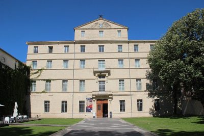 Art galleryMusée Fabre6.4 km south, in MontpellierCathedralCathedralCathédrale Saint-Pierre de Montpellier6.1 km south, in MontpellierFortFortArc de triomphe de Montpellier6.3 km south, in MontpellierChâteauChâteauMontdardier36 km northwest, in Montdardier
 GardenJardin des plantes de Montpellier5.9 km south, in Montpellier
 MuseumLattara12 km south, in Lattes
 ChâteauCitadelle de Montpellier6.6 km south, in MontpellierAbbeyAbbeyAbbaye de Gellone26 km west, in Saint-Guilhem-le-Désert
 ChâteauChâteau de Flaugergues8.1 km southeast, in MontpellierAttractionAttractionPont du Diable24 km west, in Aniane
 Archaeological sitePont Ambroix24 km east, in Gallargues-le-MontueuxChâteauChâteauChâteau de la Mogère9.2 km southeast, in Montpellier
Places within 40 km of Montferrier-sur-Lez with an article in both French and English Wikipedia, nearest first.
Know before you go to Montferrier-sur-Lez
What is there to see in Montferrier-sur-Lez?
The one place mapped in Montferrier-sur-Lez is Château de Montferrier-sur-Lez. We list 1 place in town. Another 37 are within 5 km of the centre.
Are there museums in or near Montferrier-sur-Lez?
6 museums and galleries in town or within 5 km, including Accueil, Musée de la Résistance et de la Déportation, Bâtiment M - Musée des moulages Empereur Antonin and Galerie 473.
Which places in Montferrier-sur-Lez are listed historic monuments?
One place on this page in Montferrier-sur-Lez is a listed or registered historic monument (Mérimée): Château de Montferrier-sur-Lez.
What well-known places are within a day out of Montferrier-sur-Lez?
The nearest with articles in both French and English Wikipedia: Musée Fabre (6.4 km), Cathédrale Saint-Pierre de Montpellier (6.1 km), Arc de triomphe de Montpellier (6.3 km), Montdardier (36 km).
How is this list made?
From OpenStreetMap and Wikidata: named museums, galleries, châteaux, abbeys, gardens, zoos, theme parks and other visitor attractions whose mapped point lies inside the commune of Montferrier-sur-Lez, then those in the communes within 5 km of its centre, and well-known places within 40 km. Houses, ruins and gardens need a sign they’re open to visitors; places marked private, closed or disused are left out. The historic-monument link is the Culture ministry’s Mérimée record. A place that isn’t mapped isn’t listed, so this isn’t everything there is to see.
Sources: OpenStreetMap (© OpenStreetMap contributors, ODbL), Wikidata (CC0: descriptions, websites, Wikipedia articles), the Culture ministry’s Mérimée database (Licence Ouverte 2.0), IGN commune boundaries. Distances are from the commune’s centre point.
Photos from Wikimedia Commons, each under its own licence (our copy, resized).
Photo credits (8)
- Parc zoologique de Montpellier: yves Tennevin, CC BY 2.0, Wikimedia Commons
- Château d'Ô: Vpe, CC BY-SA 3.0, Wikimedia Commons
- Musée Fabre: Björn S., CC BY-SA 3.0, Wikimedia Commons
- Jardin des plantes de Montpellier: Alexander Baranov from Montpellier, France, CC BY 2.0, Wikimedia Commons
- Lattara: Arnaud Fafournoux, CC BY-SA 3.0, Wikimedia Commons
- Citadelle de Montpellier: Photographié et édité par User:Sebjarod (floutage des plaques d'immatriculation), décembre 2004., Public domain, Wikimedia Commons
- Château de Flaugergues: Vpe, CC BY-SA 3.0, Wikimedia Commons
- Pont Ambroix: Xabi Rome-Hérault, CC BY 3.0, Wikimedia Commons
Contains public sector information under the Licence Ouverte / Open Licence 2.0 (Etalab): INSEE, DGFiP, the Interior Ministry’s statistics service (SSMSI), the Ministry of Education (DEPP), the Health Ministry’s statistics service (DREES) and the Housing Ministry (Carte des loyers). Commune boundaries: IGN Admin Express.