
Menhir de la Croix Fry: Manigod’s one place to visit
We list one place to visit in Manigod and 3 within 5 km of its centre. On the list: 2 attractions, a château and a museum, among others. The best-known trip out is to Beaufort, 22 km away.
Highlights of Manigod
The rest of the best known are an attraction, a château and a museum.
Best known first: by how many Wikipedia and sister-site articles cover each place (Wikidata’s count). It isn’t a ranking of how good they are.
The map view
Head to the west for most of the 3 on the list.
The first 20 on the list, numbered as below. The shape is the commune of Manigod; the orange dot is its centre. © OpenStreetMap contributors · commune boundary: IGN
Kinds of place
It comes down to 2 attractions, a château and a museum.
Dark: in Manigod. Light: in the communes within 5 km of its centre.
Every place to visit
The town has one; within 5 km of its centre, the list finds 3 more.
The one place in Manigod, then those within 5 km of its centre.
Within a day
Allow a day for Beaufort, 22 km away, the pick of 12.
 MuseumTramway du Mont-Blanc26 km east, in Saint-Gervais-les-BainsCathedralCathedralCathédrale Saint-Pierre d'Annecy20 km west, in AnnecyAttractionAttractionLe Brévent37 km east, in Chamonix-Mont-Blanc
 ChâteauChâteau de Thorens17 km northwest, in Fillière
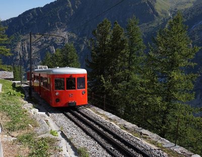 MuseumChemin de fer du Montenvers39 km east, in Chamonix-Mont-BlancChâteauChâteauChâteau de Chevron21 km south, in MercuryAbbeyAbbeyAbbaye d'Entremont11 km north, in Glières-Val-de-BorneChâteauChâteauChâteau de Sales17 km northwest, in Fillière
Places within 40 km of Manigod with an article in both French and English Wikipedia, nearest first.
Manigod, answered
What is there to see in Manigod?
The one place mapped in Manigod is Menhir de la Croix Fry. We list 1 place in town. Another 3 are within 5 km of the centre.
Are there museums in or near Manigod?
One, in town or within 5 km: Musée des Vallées de Thônes.
What well-known places are within a day out of Manigod?
The nearest with articles in both French and English Wikipedia: Beaufort (22 km), Aiguille du Midi (40 km), Château de Menthon-Saint-Bernard (13 km), Château d'Annecy (20 km).
How is this list made?
From OpenStreetMap and Wikidata: named museums, galleries, châteaux, abbeys, gardens, zoos, theme parks and other visitor attractions whose mapped point lies inside the commune of Manigod, then those in the communes within 5 km of its centre, and well-known places within 40 km. Houses, ruins and gardens need a sign they’re open to visitors; places marked private, closed or disused are left out. The historic-monument link is the Culture ministry’s Mérimée record. A place that isn’t mapped isn’t listed, so this isn’t everything there is to see.
Sources: OpenStreetMap (© OpenStreetMap contributors, ODbL), Wikidata (CC0: descriptions, websites, Wikipedia articles), the Culture ministry’s Mérimée database (Licence Ouverte 2.0), IGN commune boundaries. Distances are from the commune’s centre point.
Photos from Wikimedia Commons, each under its own licence (our copy, resized).
Photo credits (3)
- Tramway du Mont-Blanc: Florian Pépellin, CC BY-SA 4.0, Wikimedia Commons
- Château de Thorens: The original uploader was Seraphin74 at French Wikipedia ., CC BY-SA 2.0, Wikimedia Commons
- Chemin de fer du Montenvers: Tiia Monto, CC BY-SA 3.0, Wikimedia Commons
Contains public sector information under the Licence Ouverte / Open Licence 2.0 (Etalab): INSEE, DGFiP, the Interior Ministry’s statistics service (SSMSI), the Ministry of Education (DEPP), the Health Ministry’s statistics service (DREES) and the Housing Ministry (Carte des loyers). Commune boundaries: IGN Admin Express.