Hôtel de ville de Saint-Côme-d'Olt
Medieval castle in Saint-Côme-d'Olt in the Aveyron département of France.
Each edition grades its towns against each other only.

Among the places to visit in and near Saint-Côme-d'Olt are 4 museums, 3 châteaux and 3 attractions. One place to visit is mapped in Saint-Côme-d'Olt, with 10 more within 5 km of its centre. In town, one site is a listed historic monument. Drive 26 km to reach Cathédrale Notre-Dame de Rodez.
Then come 3 museums, a château and a fort, behind Hôtel de ville de Saint-Côme-d'Olt.
 ChâteauChâteau de Calmont d'Olt4.6 km west, in EspalionFortFortEnceinte de Flaujac2.1 km northwest, in Espalion
 MuseumAncienne église Saint-Jean-Baptiste d'Espalion3.9 km west, in Espalion
 MuseumMusée du Scaphandre3.8 km west, in Espalion
 MuseumMusée du Rouergue4 km west, in Espalion
Best known first: by how many Wikipedia and sister-site articles cover each place (Wikidata’s count). It isn’t a ranking of how good they are.
To the west is where most of the 10 lie.
The first 20 on the list, numbered as below. The shape is the commune of Saint-Côme-d'Olt; the orange dot is its centre. © OpenStreetMap contributors · commune boundary: IGN
4 châteaux or heritage sites and 4 museums or galleries top the count.
Dark: in Saint-Côme-d'Olt. Light: in the communes within 5 km of its centre.
It starts in town with one place and goes on to 10 within 5 km of its centre.
Medieval castle in Saint-Côme-d'Olt in the Aveyron département of France.
Former church located in Aveyron, in France.
Chapel located in Aveyron, in France.
The one place in Saint-Côme-d'Olt, then those within 5 km of its centre.
The history of Saint-Côme-d'Olt → · Parks and trails in Saint-Côme-d'Olt →
The standout of the 12 is Cathédrale Notre-Dame de Rodez, 26 km from town.
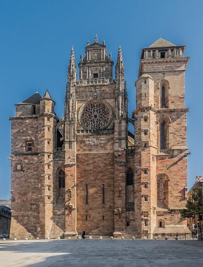 AttractionCathédrale Notre-Dame de Rodez26 km southwest, in RodezMonastery or conventMonastery or conventAbbatiale Sainte-Foy de Conques34 km west, in Conques-en-RouergueGardenGardenJardin botanique d'Aubrac12 km northeast, in Saint-Chély-d'AubracChâteauChâteauChâteau du Bousquet15 km north, in Montpeyroux
 MuseumMusée des beaux-arts Denys-Puech26 km southwest, in RodezZooZooMicropolis37 km southeast, in Saint-LéonsChâteauChâteauChâteau de Sévérac30 km southeast, in Sévérac d'AveyronChâteauChâteauChâteau de Vieillevie34 km northwest, in VieillevieAbbeyAbbeyAbbaye Notre-Dame-de-l'Assomption de Montsalvy32 km northwest, in MontsalvyChâteauChâteauChâteau de Vézins-de-Lévézou29 km southeast, in Vézins-de-LévézouChâteauChâteauChâteau de Couffour39 km northeast, in Chaudes-AiguesChâteauChâteauChâteau de Pruines24 km west, in Pruines
Places within 40 km of Saint-Côme-d'Olt with an article in both French and English Wikipedia, nearest first.
The one place mapped in Saint-Côme-d'Olt is Hôtel de ville de Saint-Côme-d'Olt. We list 1 place in town. Another 10 are within 5 km of the centre.
4 museums and galleries in town or within 5 km, including Ancienne église Saint-Jean-Baptiste d'Espalion, Musée du Scaphandre, Musée du Rouergue and Musée Joseph-Vaylet.
One place on this page in Saint-Côme-d'Olt is a listed or registered historic monument (Mérimée): Hôtel de ville de Saint-Côme-d'Olt.
The nearest with articles in both French and English Wikipedia: Cathédrale Notre-Dame de Rodez (26 km), Abbatiale Sainte-Foy de Conques (34 km), Jardin botanique d'Aubrac (12 km), Château du Bousquet (15 km).
From OpenStreetMap and Wikidata: named museums, galleries, châteaux, abbeys, gardens, zoos, theme parks and other visitor attractions whose mapped point lies inside the commune of Saint-Côme-d'Olt, then those in the communes within 5 km of its centre, and well-known places within 40 km. Houses, ruins and gardens need a sign they’re open to visitors; places marked private, closed or disused are left out. The historic-monument link is the Culture ministry’s Mérimée record. A place that isn’t mapped isn’t listed, so this isn’t everything there is to see.
Sources: OpenStreetMap (© OpenStreetMap contributors, ODbL), Wikidata (CC0: descriptions, websites, Wikipedia articles), the Culture ministry’s Mérimée database (Licence Ouverte 2.0), IGN commune boundaries. Distances are from the commune’s centre point.
Photos from Wikimedia Commons, each under its own licence (our copy, resized).
Contains public sector information under the Licence Ouverte / Open Licence 2.0 (Etalab): INSEE, DGFiP, the Interior Ministry’s statistics service (SSMSI), the Ministry of Education (DEPP), the Health Ministry’s statistics service (DREES) and the Housing Ministry (Carte des loyers). Commune boundaries: IGN Admin Express.