Fort de Saint-Cyr
Montigny-le-Bretonneux counts Fort de Saint-Cyr among its places to visit. Its neighbours on our list number 17 within 5 km. It was listed in 1992 as a classé historic monument.
Fort in Montigny-le-Bretonneux
One of the best-known places to visit in France
#1,261 of the 37,318 museums, châteaux, gardens and other attractions we list in France, by how widely it is covered (6 Wikipedia and sister-site articles). About ↓
In Montigny-le-Bretonneux
Fort de Saint-Cyr is in the commune of Montigny-le-Bretonneux, with 17 more places to visit within 5 km. Towns near it ↓
Classé historic monument
Protected as a historic monument since 1992; built in the 19th century (Mérimée record PA00087791). About ↓
Written from OpenStreetMap, Wikidata, the Culture ministry’s Mérimée database and Météo-France 1991–2020 normals.
Month by month
The warmest afternoons in Montigny-le-Bretonneux run May to September, at 19–25°C.
Fort de Saint-Cyr
Articles on it exist in 6 languages. The first to add nearby is Château de Versailles, at 6.7 km.
- Type
- Fort
- Protection
- Classé historic monument · 1992
- Built
- 19th century
- Covered in
- 6 Wikipedia and sister-site articles
- Commune
- Montigny-le-Bretonneux, Yvelines
Mapping Fort de Saint-Cyr
The map puts Fort de Saint-Cyr in orange and numbers its neighbours as in the list.
© OpenStreetMap contributors · The dashed line is the commune of Montigny-le-Bretonneux. · commune boundary: IGN
Nearby towns
By population, Trappes leads the 8 with 34,689. Nearest first, every town here counts it among its places to visit.
- 1Montigny-le-Bretonneux
- 2Bois-d'Arcy
- 3Fontenay-le-Fleury
- 4Saint-Cyr-l'École
- 5Guyancourt
- 6Trappes
- 7Voisins-le-Bretonneux
- 8Villepreux
Montigny-le-Bretonneux
Bois-d'Arcy
Fontenay-le-Fleury
Saint-Cyr-l'École
Compare the 8 towns
| Town | Where Fort de Saint-Cyr is | People |
|---|---|---|
| Montigny-le-Bretonneux | It’s in this commune | 32,465 |
| Bois-d'Arcy | 1.2 km northwest of it | 16,586 |
| Fontenay-le-Fleury | 2.4 km northeast of it | 13,680 |
| Saint-Cyr-l'École | 2.7 km northeast of it | 21,268 |
| Guyancourt | 3.4 km southeast of it | 29,778 |
| Trappes | 3.4 km southwest of it | 34,689 |
| Voisins-le-Bretonneux | 4 km south of it | 10,624 |
| Villepreux | 4.5 km northwest of it | 11,931 |
Also within reach
383 more lie within 15 km, 5 attractions, 2 châteaux and a garden among them.
 AttractionChâteau de Versailles6.7 km east, in Versailles2
 AttractionPetit Trianon6.1 km northeast, in Versailles3
 AttractionGrand Trianon6 km northeast, in Versailles4AttractionAttractionAbbaye de Port-Royal-des-Champs à Magny-les-Hameaux5.6 km south, in Magny-les-Hameaux5ChâteauChâteauChâteau de Saint-Germain-en-Laye13 km north, in Saint-Germain-en-Laye6
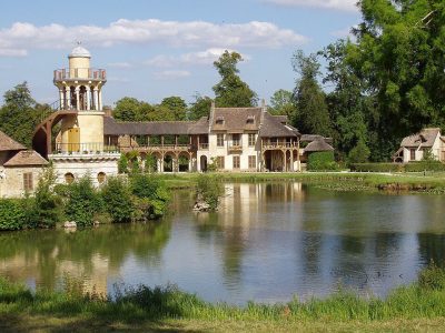 AttractionHameau de la Reine6.7 km northeast, in Versailles7
 GardenJardin de Versailles5.9 km east, in Versailles8ChâteauChâteauChâteau de Malmaison13 km northeast, in Rueil-Malmaison
Within 15 km, close and well known first. Numbers match the map.
Fort de Saint-Cyr: what to know
Where is Fort de Saint-Cyr?
Fort de Saint-Cyr is in Montigny-le-Bretonneux, in Yvelines (Île-de-France).
What is Fort de Saint-Cyr?
Fort.
Is Fort de Saint-Cyr a historic monument?
Yes: Classé historic monument, since 1992, Mérimée record PA00087791.
How well known is Fort de Saint-Cyr?
Fort de Saint-Cyr has 6 Wikipedia and sister-site articles in different languages: #1,261 of the 37,318 French places we list.
When is the best time to visit Fort de Saint-Cyr?
May to September are the warmest months in Montigny-le-Bretonneux, with afternoon highs of 19–25°C (Météo-France 1991–2020 normals).
What else is there to see near Fort de Saint-Cyr?
Within 15 km: Château de Versailles (6.7 km), Petit Trianon (6.1 km), Grand Trianon (6 km) and Abbaye de Port-Royal-des-Champs à Magny-les-Hameaux (5.6 km).
Sources: OpenStreetMap (© OpenStreetMap contributors, ODbL), Wikidata (CC0: what it is, its articles, how widely it is covered), the Culture ministry’s Mérimée database (Licence Ouverte 2.0), IGN commune boundaries, Météo-France 1991–2020 normals (Licence Ouverte 2.0).
Photos from Wikimedia Commons, each under its own licence (our copy, resized).
Photo credits (5)
- Château de Versailles: ToucanWings, CC BY-SA 3.0, Wikimedia Commons
- Petit Trianon: KimonBerlin, CC BY-SA 2.0, Wikimedia Commons
- Grand Trianon: Lionel Allorge, CC BY-SA 3.0, Wikimedia Commons
- Hameau de la Reine: Daderot, CC BY-SA 3.0, Wikimedia Commons
- Jardin de Versailles: Anonymous Unknown author, Public domain, Wikimedia Commons
Contains public sector information under the Licence Ouverte / Open Licence 2.0 (Etalab): INSEE, DGFiP, the Interior Ministry’s statistics service (SSMSI), the Ministry of Education (DEPP), the Health Ministry’s statistics service (DREES) and the Housing Ministry (Carte des loyers). Commune boundaries: IGN Admin Express.