Château Rivet
Among the sights of Les Ponts-de-Cé is Château Rivet. Within 5 km there are 51 more places to visit. It was listed in 1964 as a registered historic monument (inscrit, in part).
Château in Les Ponts-de-Cé
In Les Ponts-de-Cé
Château Rivet is in the commune of Les Ponts-de-Cé, with 51 more places to visit within 5 km. Towns near it ↓
Registered historic monument (inscrit, in part)
Protected as a historic monument since 1964; built in the 15th and 16th centuries (Mérimée record PA00109236). About ↓
Written from OpenStreetMap, Wikidata, the Culture ministry’s Mérimée database and Météo-France 1991–2020 normals.
Month by month
Afternoons in Les Ponts-de-Cé reach 17–26°C from May to October.
Château Rivet
Around it, Château d'Angers (4.9 km) comes first on our list.
- Type
- Château
- Protection
- Registered historic monument (inscrit, in part) · 1964
- Built
- 15th and 16th centuries
- Commune
- Les Ponts-de-Cé, Maine-et-Loire
The way to Château Rivet
Orange shows Château Rivet; numbers mark the places near it.
© OpenStreetMap contributors · The dashed line is the commune of Les Ponts-de-Cé. · commune boundary: IGN
Nearby towns
The biggest base of the 8 is Angers (159,022 people). Start with its own town; the others follow by distance.
- 1Les Ponts-de-Cé
- 2Trélazé
- 3Saint-Barthélemy-d'Anjou
- 4Sainte-Gemmes-sur-Loire
- 5Angers
- 6Mûrs-Erigné
- 7Les Garennes sur Loire
- 8Bouchemaine
Les Ponts-de-Cé
Trélazé
Saint-Barthélemy-d'Anjou
Sainte-Gemmes-sur-Loire
Compare the 8 towns
| Town | Where Château Rivet is | People |
|---|---|---|
| Les Ponts-de-Cé | It’s in this commune | 13,149 |
| Trélazé | 2.7 km northeast of it | 16,333 |
| Saint-Barthélemy-d'Anjou | 3.8 km northeast of it | 9,720 |
| Sainte-Gemmes-sur-Loire | 3.9 km west of it | 3,685 |
| Angers | 4.4 km northwest of it | 159,022 |
| Mûrs-Erigné | 4.7 km south of it | 6,408 |
| Les Garennes sur Loire | 5.2 km southeast of it | 4,663 |
| Bouchemaine | 7.4 km west of it | 6,580 |
Beyond Château Rivet
Choose from 168 places within 15 km, such as 2 châteaux, 2 museums and 2 gardens.
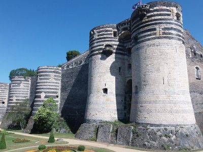 AttractionChâteau d'Angers4.9 km northwest, in Angers2
 CathedralCathédrale Saint-Maurice d'Angers4.7 km northwest, in Angers3
 ChâteauChâteau de Brissac11 km southeast, in Brissac Loire Aubance4
 MuseumMusée des Beaux-Arts d'Angers4.5 km northwest, in Angers5GardenGardenJardin des plantes d'Angers4.6 km northwest, in Angers6ChâteauChâteauChâteau de Pignerolle4.8 km northeast, in Saint-Barthélemy-d'Anjou7GardenGardenArboretum Gaston-Allard2.5 km northwest, in Angers8
 MuseumMuseum d'histoire naturelle d'Angers4.6 km northwest, in Angers
Within 15 km, close and well known first. Numbers match the map.
Your questions on Château Rivet
Where is Château Rivet?
Château Rivet is in Les Ponts-de-Cé, in Maine-et-Loire (Pays de la Loire).
What is Château Rivet?
Château.
Is Château Rivet a historic monument?
Yes: Registered historic monument (inscrit, in part), since 1964, Mérimée record PA00109236.
When is the best time to visit Château Rivet?
May to October are the warmest months in Les Ponts-de-Cé, with afternoon highs of 17–26°C (Météo-France 1991–2020 normals).
What else is there to see near Château Rivet?
Within 15 km: Château d'Angers (4.9 km), Cathédrale Saint-Maurice d'Angers (4.7 km), Château de Brissac (11 km) and Musée des Beaux-Arts d'Angers (4.5 km).
Sources: OpenStreetMap (© OpenStreetMap contributors, ODbL), Wikidata (CC0: what it is, its articles, how widely it is covered), the Culture ministry’s Mérimée database (Licence Ouverte 2.0), IGN commune boundaries, Météo-France 1991–2020 normals (Licence Ouverte 2.0).
Photos from Wikimedia Commons, each under its own licence (our copy, resized).
Photo credits (5)
- Château d'Angers: Nataloche, CC BY-SA 4.0, Wikimedia Commons
- Cathédrale Saint-Maurice d'Angers: Denis Pithon, CC BY-SA 3.0, Wikimedia Commons
- Château de Brissac: JackyM59, CC BY-SA 4.0, Wikimedia Commons
- Musée des Beaux-Arts d'Angers: Selbymay, CC BY-SA 3.0, Wikimedia Commons
- Museum d'histoire naturelle d'Angers: Okapie49, CC BY-SA 4.0, Wikimedia Commons
Contains public sector information under the Licence Ouverte / Open Licence 2.0 (Etalab): INSEE, DGFiP, the Interior Ministry’s statistics service (SSMSI), the Ministry of Education (DEPP), the Health Ministry’s statistics service (DREES) and the Housing Ministry (Carte des loyers). Commune boundaries: IGN Admin Express.