Arboretum Gaston-Allard
In Angers, Arboretum Gaston-Allard is a garden. 63 more places to visit are within 5 km. The first to add nearby is Château d'Angers, at 2.5 km.
Garden in Angers
One of the best-known places to visit in France
#2,141 of the 37,318 museums, châteaux, gardens and other attractions we list in France, by how widely it is covered (4 Wikipedia and sister-site articles). About ↓
In Angers
Arboretum Gaston-Allard is in the commune of Angers, with 63 more places to visit within 5 km. Towns near it ↓
Written from OpenStreetMap, Wikidata and Météo-France 1991–2020 normals.
The best months to visit
For warmth, aim for May to October (17–26°C highs in Angers).
Arboretum Gaston-Allard
There are Wikipedia articles on it in 4 languages.
- Type
- Garden
- Covered in
- 4 Wikipedia and sister-site articles
- Commune
- Angers, Maine-et-Loire
Where to find Arboretum Gaston-Allard
Orange is Arboretum Gaston-Allard; numbered in green, the places near it.
© OpenStreetMap contributors · The dashed line is the commune of Angers. · commune boundary: IGN
Towns that list Arboretum Gaston-Allard
Home to 159,022 people, Angers is the largest of these 8. Pick a base: each town is a page of its own, with what else there is to see.
- 1Angers
- 2Les Ponts-de-Cé
- 3Sainte-Gemmes-sur-Loire
- 4Saint-Barthélemy-d'Anjou
- 5Trélazé
- 6Bouchemaine
- 7Mûrs-Erigné
- 8Avrillé
Angers
Les Ponts-de-Cé
Sainte-Gemmes-sur-Loire
Saint-Barthélemy-d'Anjou
Compare the 8 towns
| Town | Where Arboretum Gaston-Allard is | People |
|---|---|---|
| Angers | It’s in this commune | 159,022 |
| Les Ponts-de-Cé | 2.6 km southeast of it | 13,149 |
| Sainte-Gemmes-sur-Loire | 3.3 km southwest of it | 3,685 |
| Saint-Barthélemy-d'Anjou | 4.1 km northeast of it | 9,720 |
| Trélazé | 4.3 km east of it | 16,333 |
| Bouchemaine | 5.6 km west of it | 6,580 |
| Mûrs-Erigné | 6 km south of it | 6,408 |
| Avrillé | 6.7 km northwest of it | 15,251 |
What else is near Arboretum Gaston-Allard
2 museums, an attraction and a cathedral are among the 174 within 15 km.
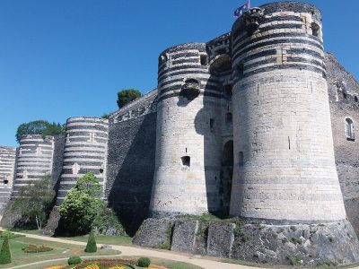 AttractionChâteau d'Angers2.5 km northwest, in Angers2
 CathedralCathédrale Saint-Maurice d'Angers2.4 km northwest, in Angers3
 ChâteauChâteau de Brissac13 km southeast, in Brissac Loire Aubance4
 MuseumMusée des Beaux-Arts d'Angers2.2 km northwest, in Angers5GardenGardenJardin des plantes d'Angers2.7 km north, in Angers6AbbeyAbbeyAbbaye Saint-Aubin d'Angers2.1 km northwest, in Angers7
 MuseumMuseum d'histoire naturelle d'Angers2.5 km north, in Angers8Monastery or conventMonastery or conventAbbaye Saint-Nicolas d'Angers3.7 km northwest, in Angers
Within 15 km, close and well known first. Numbers match the map.
What people ask about Arboretum Gaston-Allard
Where is Arboretum Gaston-Allard?
Arboretum Gaston-Allard is in Angers, in Maine-et-Loire (Pays de la Loire).
What is Arboretum Gaston-Allard?
Garden in France.
How well known is Arboretum Gaston-Allard?
Arboretum Gaston-Allard has 4 Wikipedia and sister-site articles in different languages: #2,141 of the 37,318 French places we list.
When is the best time to visit Arboretum Gaston-Allard?
May to October are the warmest months in Angers, with afternoon highs of 17–26°C (Météo-France 1991–2020 normals).
What else is there to see near Arboretum Gaston-Allard?
Within 15 km: Château d'Angers (2.5 km), Cathédrale Saint-Maurice d'Angers (2.4 km), Château de Brissac (13 km) and Musée des Beaux-Arts d'Angers (2.2 km).
Sources: OpenStreetMap (© OpenStreetMap contributors, ODbL), Wikidata (CC0: what it is, its articles, how widely it is covered), the Culture ministry’s Mérimée database (Licence Ouverte 2.0), IGN commune boundaries, Météo-France 1991–2020 normals (Licence Ouverte 2.0).
Photos from Wikimedia Commons, each under its own licence (our copy, resized).
Photo credits (5)
- Château d'Angers: Nataloche, CC BY-SA 4.0, Wikimedia Commons
- Cathédrale Saint-Maurice d'Angers: Denis Pithon, CC BY-SA 3.0, Wikimedia Commons
- Château de Brissac: JackyM59, CC BY-SA 4.0, Wikimedia Commons
- Musée des Beaux-Arts d'Angers: Selbymay, CC BY-SA 3.0, Wikimedia Commons
- Museum d'histoire naturelle d'Angers: Okapie49, CC BY-SA 4.0, Wikimedia Commons
Contains public sector information under the Licence Ouverte / Open Licence 2.0 (Etalab): INSEE, DGFiP, the Interior Ministry’s statistics service (SSMSI), the Ministry of Education (DEPP), the Health Ministry’s statistics service (DREES) and the Housing Ministry (Carte des loyers). Commune boundaries: IGN Admin Express.