Crestone’s post office opened in 1880, and 1 of its places is on the National Register
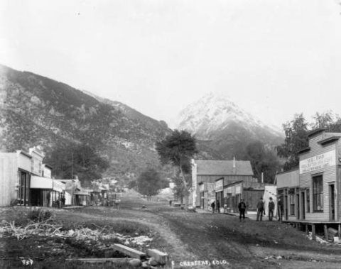
Most of Crestone was built recently: 0.0% of its homes predate 1940 and the median home dates from 1989. Its Register listing is the Crestone School. Below: 2 old photos and papers, maps from 1982 on, and the census since 1910.
The Crestone post office opened in 1880, the earliest record of the town by name. Another post office, Cristonie (1872), opened inside today’s town and later closed.
First census: 231 in 19102020 census: 141146 years
Founding year: the first Crestone post office (Blevins & Helbock, CC0).The full story ↓
What stands out about Crestone’s past
Read from the archive, the National Register and the record. The page puts what stands out first.
The first settlement in the Crestone area occurred after the American Civil War with the granting of the Luis Maria Baca Grant No. 4 in 1860 to the heirs of the original Baca Grant at Las Vegas, New Mexico. Title to the grant at Las Vegas was clouded by a second grant of the same land to the residents of Las Vegas, the Bacas having abandoned their grant after the deaths of the founder to a Mexican soldier in 1827 and of his oldest son at the hands of the Navajo in 1835. The Baca heirs were offered alternative lands from the public lands of the United States. The square tract selected is 12.5 miles (20.1 km) on a side south of Saguache County Road T south of Crestone. The Bacas deeded the land to their attorney, but it soon passed by tax sale to a third party. The ranch headquarters were on Crestone Creek to the southwest of Crestone. The Baca Grant was one of the first large tracts of l…
Nothing in the archives for these yearsWeddings on Main Street, storms, parades, school pictures, the old store. If it’s in your family album, it belongs here.
Founding dates: Wikidata, Wikipedia, the U.S. post office records of Blevins & Helbock (CC0) and the Census. Homes by year built: Census ACS 2020–24. National Register of Historic Places: National Park Service (list of May 22, 2026). Old photos, postcards and papers: Wikimedia Commons, the Library of Congress and other public archives, credited on each item’s page. Maps: U.S. Geological Survey historical topographic maps (via Esri) and Sanborn fire-insurance maps (Library of Congress). History text and census tables: Wikipedia (CC BY-SA 4.0). Places that used to be: USGS Geographic Names Information System (2021). How TownRatings grades history →
From Wikimedia Commons (5), Wikidata (1), the National Register of Historic Places (1), Wikipedia, U.S. Geological Survey historical maps, U.S. Census counts (via Wikipedia), the US Post Offices dataset (Blevins & Helbock) and the USGS Geographic Names Information System. Archive images are copied here with their credits and licenses, shown on each photo’s page. Refreshed monthly.




 2003
 2003
 2003

