Boulder dates to 1858, and 22 of its places are on the National Register
More historic than 58% of U.S. towns · #26 of 159 in Colorado. What drives it
Most of Boulder was built recently: 8% of its homes predate 1940 and the median home dates from 1977. 22 places in town are on the National Register, among them 2 National Historic Landmarks and five historic districts with 226 buildings between them. Below: 5 old photos and papers, maps from 1883 on, and the census since 1870.
Founding year: Wikidata; Wikipedia’s history section gives the same year. First post office: 1859.The full story ↓
History grade
What drives Boulder’s History grade
On its age, its old homes and the National Register, Boulder is more historic than 58% of U.S. towns, #26 of 159 in Colorado. Its National Register listings hold the grade up; its age pulls it down.
B
HistoryA character grade: shown, never part of Boulder’s overall grade.
Among the 400 U.S. cities of 100,000 or more, Boulder ranks #218 on History.
Few Colorado towns list much on the Register (a typical Colorado town has 1.1 per 10,000 residents, the U.S. 2.4), so Boulder’s 22.7 sits above most of its state (80% of Colorado towns have fewer) while its 242 historic buildings outnumber those of 94% of U.S. towns.
How sure. Graded on any two of the three inputs instead, the letter would range from C to B+. The pre-1940 share (±1.2 points) is firm at this size. Two sources give 1858.
Founding year: Wikidata (other dates in Quick answers). Homes: Census ACS 2020–24. National Register: National Park Service, May 2026 list; each listing counted once (boundary changes and added documentation belong to their listing), and a historic district counts its contributing buildings. How TownRatings grades history →
What stands out about Boulder’s past
Read from the archive, the National Register and the record. The page puts what stands out first.
National Park Service, National Register of Historic Places. Photos from Wikimedia Commons, credited on each place’s page.
Every building
Boulder, building by building, 1883–1922
Fire insurance maps drew every building, what it was made of and what it was used for, so insurers could price the risk of fire. Pick a year, then a sheet.
Archaeological evidence shows that Boulder Valley has been continuously inhabited by Native American tribes for over 13,000 years, beginning in the late Pleistocene era. Between 9500 BC and 1550 AD, indigenous peoples moved seasonally between the mountains and plains, taking shelter in winter along the Front Range trough where Boulder now lies. By the 1500s, the Ute people held primary occupation of Boulder Valley. In the early 1800s, the Arapaho migrated to the region. Additional Native American nations with historical ties to the broader Front Range include the Apache, Arapaho, Cheyenne, Comanche, Kiowa, Pawnee, Shoshone, Sioux, and Ute peoples. In the 1800s, European Americans settled in the area.
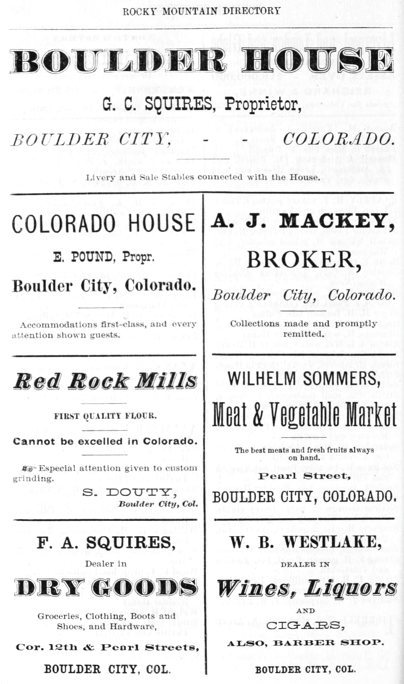
Passages that mention Boulder, cut from the printed page as they were published.
History of Clear Creek and Boulder valleys, Colorado1880 · page 404Read the page →
Read the text
The town of Boulder was incorporated the 4th of November, 1871, and the 18th of the following month voted $10,000 in bonds for the purpose of building the bridges for the railroad in question from Erie to Boulder. Avoidance of the payment of these bonds was afterward sought, on the ground of the failure of the railroad company to comply with their part of the
Text read by machine from the scan; it may contain errors.
History of Clear Creek and Boulder valleys, Colorado1880 · page 606Read the page →
Read the text
war, then resided in Atchison Co., .Mo., from 1844 to 1858. In November, 1858, he emigrated to Colorado, and was engaged in mining at Gold Hill, Boulder Co., until the fall of 1859, then returned East, and removed his family to Colorado, in the spring of 1860, residing in Boulder one year, occupying his attention in mining pursuits, then pre-empted 160 acres of
Text read by machine from the scan; it may contain errors.
Scans and text from the Internet Archive. Books published in 1930 or earlier, which are in the public domain.
Timeline
Boulder, 1858 to 2024
Woven from the archive, old maps, post office records, the National Register and the people born here.
Nothing in the archives for these yearsWeddings on Main Street, storms, parades, school pictures, the old store. If it’s in your family album, it belongs here.
Lost post offices, old corners, places now gone and burying grounds
Boulder’s post office has been open since 1859. Another post office, Valmont, opened and closed inside today’s town.
Boulder
1859–today
Valmont
1865–1901
18501940today
Hamlets and corners on the map
Ara
Gone or out of use
Arapahoe PitmineBarron MinemineBase Line SchoolschoolBelmont MinemineBlue Ribbon MinemineBoulder County HospitalhospitalBoulder Pit Number 485mineBrannan Pit Number 14mineBuckskin Joe Number One MinemineCarfield MinemineColorado Miracle MinemineCopeland MinemineDegge Clark MinemineDoolittle MinemineEast Boston MinemineElla C MinemineEssco MinemineFlatiron Sand and Gravel Pitmine
2cemeteries and burying grounds inside Boulder
ColumbiaGreen Mountain
US Post Offices dataset (Blevins & Helbock, CC0). Places and cemeteries from the USGS Geographic Names Information System (2021).
Help out
Finish Boulder’s story
Most archives stop around 1920. The photos from after that are in family albums, not libraries.
Decades since 1900 with photos
00s10s20s30s40s50s60s70s80s90s
0 of 10 decades. The empty ones are waiting for someone’s album.
In 1858, according to Wikidata and Wikipedia’s history of the town. Boulder’s post office opened in 1859, and the census of 1870 counted 343 people here.
How does Boulder rank for history?
Boulder is more historic than 58% of U.S. towns, #26 of 159 in Colorado. The History grade combines the town’s founding era, the share of homes built before 1940 and its National Register listings. It’s a character grade, so it isn’t part of the overall grade. How it works.
What is on the National Register in Boulder?
22 listings, 2 of them National Historic Landmarks: 15 buildings, among them the Chautauqua Auditorium (listed 1974, the first), 5 historic districts with 226 contributing buildings, 1 site, and 1 structure. 242 historic buildings in all.
How old are the homes in Boulder?
8% of Boulder’s homes were built before 1940 (Census estimate, ±1.2 points), against a typical 2.5% for a Colorado town; the median home was built in 1977.
Founding dates: Wikidata, Wikipedia, the U.S. post office records of Blevins & Helbock (CC0) and the Census. Homes by year built: Census ACS 2020–24. National Register of Historic Places: National Park Service (list of May 22, 2026). Old photos, postcards and papers: Wikimedia Commons, the Library of Congress and other public archives, credited on each item’s page. Maps: U.S. Geological Survey historical topographic maps (via Esri) and Sanborn fire-insurance maps (Library of Congress). History text and census tables: Wikipedia (CC BY-SA 4.0). Places that used to be: USGS Geographic Names Information System (2021).
From Wikimedia Commons (4), the Library of Congress (1), Wikidata (1), the National Register of Historic Places (22), Wikipedia, Wikidata and Wikipedia for famous people, U.S. Geological Survey historical maps, U.S. Census counts (via Wikipedia), the US Post Offices dataset (Blevins & Helbock), the USGS Geographic Names Information System, Sanborn fire insurance maps (Library of Congress) and old county and town histories (Internet Archive). Archive images are copied here with their credits and licenses, shown on each photo’s page. Refreshed monthly.


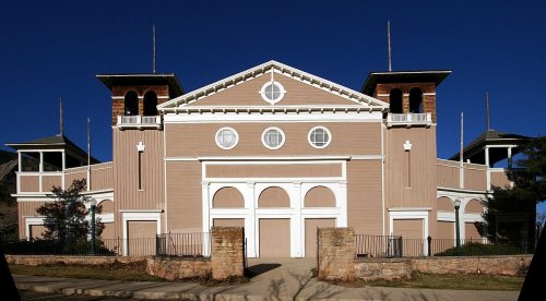 ★ Landmark


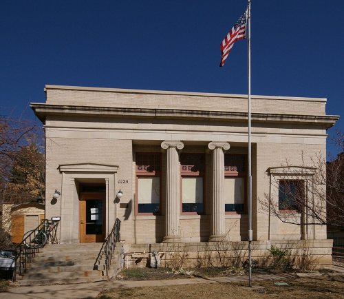




 1871
 1873