Antonito’s post office opened in 1881, and 30% of its homes were built before 1940
5 places in town are on the National Register, among them a historic district with 15 buildings. Below: 1 old photo or paper, maps from 1890 on, and the census since 1890.
Peaked at 1,255 in 1950; 647 people lived here in 2020.
14 censuses, 1890–2020.
U.S. Census Bureau decennial counts, from the census table on Antonito’s Wikipedia page.
Every building
Antonito, building by building, 1890–1914
Fire insurance maps drew every building, what it was made of and what it was used for, so insurers could price the risk of fire. Pick a year, then a sheet.
Antonito began life as a sheep herding camp known as San Antonio Junction, referring to its proximity to the Conejos and San Antonio rivers. When the Denver & Rio Grande Railroad built its line south from Alamosa, the town was renamed Antonito and became an important town on the railroad line. The San Antonio, Colorado, post office moved north to Antonito on January 24, 1881, and the Town of Antonito was incorporated on December 29, 1889. There are currently no major industries located in Antonito, but the historic Cumbres & Toltec Scenic Railroad has one terminus in Antonito and the other in Chama, New Mexico. The C&TS also has maintenance facilities and rail yard in the town. The Colorado Pacific Rio Grande Railroad continues to operate the rail line from Antonito to Alamosa.
Nothing in the archives for these yearsWeddings on Main Street, storms, parades, school pictures, the old store. If it’s in your family album, it belongs here.
The Antonito post office opened in 1881, the earliest record of the town by name (U.S. post office records).
What is on the National Register in Antonito?
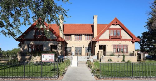
5 listings: 4 buildings, among them the Warshauer Mansion (listed 1974, the first), 1 historic district, the Denver & Rio Grande Railroad San Juan Extension, with 15 contributing buildings, and 1 structure. 18 historic buildings in all.
Founding dates: Wikidata, Wikipedia, the U.S. post office records of Blevins & Helbock (CC0) and the Census. Homes by year built: Census ACS 2020–24. National Register of Historic Places: National Park Service (list of May 22, 2026). Old photos, postcards and papers: Wikimedia Commons, the Library of Congress and other public archives, credited on each item’s page. Maps: U.S. Geological Survey historical topographic maps (via Esri) and Sanborn fire-insurance maps (Library of Congress). History text and census tables: Wikipedia (CC BY-SA 4.0). Places that used to be: USGS Geographic Names Information System (2021). How TownRatings grades history →
From Wikimedia Commons (8), Wikidata (4), the National Register of Historic Places (6), Wikipedia, Wikidata and Wikipedia for famous people, U.S. Geological Survey historical maps, U.S. Census counts (via Wikipedia), the US Post Offices dataset (Blevins & Helbock), the USGS Geographic Names Information System and Sanborn fire insurance maps (Library of Congress). Archive images are copied here with their credits and licenses, shown on each photo’s page. Refreshed monthly.


 2024
 2016
 2015
 2014
 2012
 2007
 2005