
Sainte-Émélie-de-l'ÉnergieQuebec
Between 2016 and 2021, its population grew by 11%. It is a town of 1,856 residents in Quebec.
Is Sainte-Émélie-de-l'Énergie a good place to live?
Sainte-Émélie-de-l'Énergie’s best grade is for hazard risk (B+). Jobs and pay trail most towns (D−). At $180,000, the median home value in 2021 came to 3.1 times local household income. Elsewhere it is close to typical: B for safety and B for health.
Figures: home values and income: Statistics Canada, Census 2021. Sainte-Émélie-de-l'Énergie is graded subject by subject, but Canadian towns need 2,500 residents for an overall grade.
This town's rent is the 2021 census rent scaled to 2025 by its province's ratio of surveyed to census rents: no rental survey covers it, so its Cost Grade is less sure. Safety is the Sûreté du Québec unit's figure for the whole MRC. No School Grade: this province doesn't publish comparable results school by school. Health is graded on the health region's survey figures and life expectancy, with the distance to hospital giving the town its own spread.
What makes Sainte-Émélie-de-l'Énergie stand out
The 3 things Sainte-Émélie-de-l'Énergie does most differently from other towns.
How Sainte-Émélie-de-l'Énergie grades
Each subject compares Sainte-Émélie-de-l'Énergie with Canadian towns of 2,500 or more, ordered by how far it is from the middle. Towns in other countries are graded separately.
Sainte-Émélie-de-l'Énergie is graded subject by subject, but Canadian towns need 2,500 residents for an overall grade.
How TownRatings grades Canadian towns →
The data
Data highlights are ordered by what stands out in Sainte-Émélie-de-l'Énergie.
Trips to work from Sainte-Émélie-de-l'Énergie take longer than from Quebec’s towns or Canadian towns: 33 min on average
91% of commuters drove, in line with Quebec’s towns (90%) and Canadian towns (89%).
How working residents got to work · census 2021
| Census 2021 | Sainte-Émélie-de-l'Énergie | Quebec | Canada |
|---|---|---|---|
| Average trip | 33 min | 27 min | 26 min |
| Car or van | 91% | 90% | 89% |
Statistics Canada, Census 2021 (labour and commuting) · The 2021 census was taken in May 2021, during COVID-19 restrictions: more people than usual worked from home or were off work.
A flood study covers Sainte-Émélie-de-l'Énergie: 1 on the national inventory, the newest from Gouvernement du Québec
Measured across the Lanaudiere health region: radon tests
Wildfire is rare near Sainte-Émélie-de-l'Énergie: 0.1% of the land within 25 km has burned since 1986, a burn rate of 0.002% a year. In Health Canada’s survey, just 3.9% of homes tested in the area exceeded 200 Bq/m³ (6.6% typical).
Radon tests above the guideline · share of tested homes, 200 Bq/m³
| Hazards | Sainte-Émélie-de-l'Énergie | Quebec | Canada |
|---|---|---|---|
| Radon tests above the guideline | 3.9% | 8.2% | 6.6% |
| Earthquake loss per $1,000 of buildings a year | $0.048 | $0.14 | $0.030 |
NRCan seismic risk model and burned areas, Health Canada radon survey, the Flood Hazard Map Inventory
Sainte-Émélie-de-l'Énergie skews older, with 27% of residents 65 or over, more than in both Quebec’s towns and Canadian towns
13% are under 15, below both Quebec’s towns (17%) and Canadian towns (16%). Both official languages: a third of residents, below Quebec’s towns (44%) but above Canadian towns (7.5%).
Ages · Share of residents in each age group, Census 2021
Schooling · Highest qualification, residents 15 and over
Women and men · all residents
Women make up 47.1% of Sainte-Émélie-de-l'Énergie
By the 2021 count the town had 820 women and 920 men, while Canada has 50.9% women.
| Sainte-Émélie-de-l'Énergie | Quebec | Canada | |
|---|---|---|---|
| Under 15 | 13% | 17% | 16% |
| 15 to 64 | 60% | 62% | 64% |
| 65+ | 27% | 20% | 19% |
| No certificate, diploma or degree | 23% | 19% | 16% |
| Postsecondary qualification | 55% | 59% | 56% |
Statistics Canada, Census 2021; Quebec and Canada: medians of towns of 2,500+
Sainte-Émélie-de-l'Énergie is wetter than four in five Canadian towns: 1,109 mm of rain and snow a year
Snow totals 202 cm over the year, lower than Quebec’s towns (217 cm) yet higher than Canadian towns (141 cm). For the wettest month, look to August: 114 mm on average. Most of the snow comes in December, about 49 cm. Sainte-Émélie-de-l'Énergie sees July afternoons of 26.6°C on average.
Average high by season · ECCC normals, 1991–2020
| Normals, 1991–2020 | Sainte-Émélie-de-l'Énergie | Quebec | Canada |
|---|---|---|---|
| Precipitation a year | 1,109 mm | 1,041 mm | 883 mm |
| Snowfall a year | 202 cm | 217 cm | 141 cm |
| July afternoon high | 26.6°C | 26.5°C | 25.5°C |
| January night low | −16.0°C | −14.7°C | −13.5°C |
Environment and Climate Change Canada, Canadian Climate Normals 1991–2020 (L'Assomption)
The Sentier National passes Sainte-Émélie-de-l'Énergie
The protected share of the 10 km around the town is 6.3%, above Quebec’s towns (4.9%) and Canadian towns (2.3%) alike. Within 5 km are 2 beaches; Plage Municipale Sainte-Émélie-de-l'Énergie is the nearest. Also worth knowing: the nearest provincial park, Mont-Tremblant National Park (Québec), is 6.9 km away. La Mauricie National Park is the closest national park, 56 km from town.
Protected land · of the land within 10 km
| Outdoors | Sainte-Émélie-de-l'Énergie | Quebec | Canada |
|---|---|---|---|
| Public protected areas within 10 km | 17 | 10 | 4 |
| Protected land within 10 km | 6.3% | 4.9% | 2.3% |
Canadian Protected and Conserved Areas Database (CPCAD), OpenStreetMap routes and beaches
A hospital trip from Sainte-Émélie-de-l'Énergie means 34 km on average, in a straight line
In the health survey, 56% of adults in the region rated their health very good or excellent, close to Quebec’s towns (56%) and above Canadian towns (52%). For 2022/2024, the region’s figure is 82.0 years at birth, 83.7 for women and 80.3 for men. Pharmacies are closer at hand, 2.6 km away on average and 0.7 of them within 3 km of a typical home. Behind health survey and life expectancy sits data gathered across the Région de Lanaudière, with Sainte-Émélie-de-l'Énergie one part of it.
Very good or excellent health · adults, age-standardised
| Health | Sainte-Émélie-de-l'Énergie | Quebec | Canada |
|---|---|---|---|
| Chronic conditions (average share) | 15% | 15% | 17% |
| Smokers | 14% | 12% | 12% |
| Very good or excellent health | 56% | 56% | 52% |
| Life expectancy at birth | 82.0 | 82.5 | 81.5 |
Statistics Canada, Canadian Community Health Survey 2023/2024 and life expectancy 2022/2024; Open Database of Healthcare Facilities
Sainte-Émélie-de-l'Énergie gets a B for safety
Where it is policed, thefts, break-ins and damage came to 14.7 per 1,000 a year, below Quebec’s towns (16.6) and Canadian towns (31.2) alike. Violence across its police area runs at 10.8 per 1,000 residents a year.
Year by year · Crime Severity Index for each year
| 2023–2025 | Sainte-Émélie-de-l'Énergie | Quebec | Canada |
|---|---|---|---|
| Property crime per 1,000 | 14.7 | 16.6 | 31.2 |
| Violent crime | 10.8 | 12.4 | 12 |
Statistics Canada, Uniform Crime Reporting Survey, 2023–2025 average · Not measured by town: Crime Severity Index, Violent Crime Severity Index, violent crime and property crime per 1,000 (Matawinie MRC)
Sainte-Émélie-de-l'Énergie in November: highs near 5°C, lows near −3°C
Snowfall in a normal November: 12 cm. December follows at −2°C by day and −10°C by night. In November, the normal is 90 mm of rain and snow. The year peaks in July (27°C) and bottoms out in January (−16°C).
Normal highs, the months ahead · ECCC normals, 1991–2020
| Season | High | Low | Rain and snow |
|---|---|---|---|
| Winter | −4°C | −14°C | 227 mm |
| Spring | 11°C | 0°C | 265 mm |
| Summer | 25°C | 14°C | 322 mm |
| Autumn | 13°C | 3°C | 295 mm |
ECCC normals, 1991–2020 (L'Assomption); the forecast is on the Weather page
270 residents per council seat in Sainte-Émélie-de-l'Énergie, a lower ratio than two in three Quebec municipalities
The mayor of Sainte-Émélie-de-l'Énergie is Martin Héroux, who sits with 6 councillors.
Wikidata, MAMH, MMAH, Statistics Canada
Sainte-Émélie-de-l'Énergie has one public library, Bibliothèque De Sainte-Émelie-De-L'Énergie
It sits 2 km from the centre of Sainte-Émélie-de-l'Énergie.
Provincial library statistics, OpenStreetMap, the CRA and Statistics Canada
Sainte-Émélie-de-l'Énergie is a town of owners: 84% of households own their home, above Quebec’s towns and Canadian towns
Shelter took 30% or more of income for 15% of households, higher than Quebec’s towns (13%) yet lower than Canadian towns (18%).
What homes were worth · The median owner’s estimate at the 2021 census
| Census 2021 | Sainte-Émélie-de-l'Énergie | Quebec | Canada |
|---|---|---|---|
| Households owning their home | 84% | 70% | 74% |
| Median home value, 2021 | $180,000 | $300,000 | $406,000 |
| Households spending 30%+ on shelter | 15% | 13% | 18% |
| Rent as a share of income | 18% | 18% | 20% |
Statistics Canada, Census 2021; CMHC Rental Market Survey via Statistics Canada · The 2021 census asked owners what their home was worth; those values, and 2020 incomes, are what this compares.
Sainte-Émélie-de-l'Énergie’s teenagers travel 18 km to the nearest high school
| School | Level | Students | System |
|---|---|---|---|
| École primaire de l'Ami-SoleilIn Sainte-Émélie-de-l'ÉnergieElementary | Elementary | – | French public |
| Schools within 3 km | Sainte-Émélie-de-l'Énergie | Quebec | Canada |
|---|---|---|---|
| Nearest secondary school | 18 km | 1.2 km | 1.2 km |
Provincial school lists and results, 2025-26 · Towns in Quebec aren’t in the schools rankings: the ministry publishes its success rates by school service centre, not school by school.
St Charles Borromeo Cathedral and 4 more within 40 km
Nothing to visit is mapped within 5 km of Sainte-Émélie-de-l'Énergie; these are the best known within 40 km.
 CathedralSt Charles Borromeo Cathedral35 km southeast
 MuseumCanadiana Village26 km south
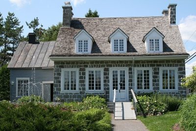 GardenMaison Antoine-Lacombe31 km southeast
 MuseumMusée d'art de Joliette35 km southeastSki hillSki hillSki Montcalm34 km south
Photos: each place’s Wikidata image, from Wikimedia Commons under the licence below (our copy, resized).
Photo credits (4)
- St Charles Borromeo Cathedral: Fralambert, CC BY-SA 4.0, Wikimedia Commons
- Canadiana Village: Conrad Poirier, Public domain, Wikimedia Commons
- Maison Antoine-Lacombe: Dreamdan, CC BY-SA 3.0, Wikimedia Commons
- Musée d'art de Joliette: Jaboileaumiss, CC BY-SA 4.0, Wikimedia Commons
Everything we know about Sainte-Émélie-de-l'Énergie
Famous people from around Sainte-Émélie-de-l'Énergie
No notable person born in Sainte-Émélie-de-l'Énergie is on our list; these were born in the towns around it.


Photo credits
Raymond Gravel: Louperivois, CC BY-SA 3.0 · Marcel Masse: Photographe de la Ville de Saint-Dié-des-Vosges, dans le cadre de sa mission ; scan par Ji-Elle, CC BY-SA 4.0 · Caroline Proulx: TVA Nouvelles, CC BY 3.0 · Guy Chevrette: Bouchecl, CC BY-SA 3.0
Sainte-Émélie-de-l'Énergie’s neighbours
The nearest places of 1,000 or more. Statistics Canada
| Town | People | km | Overall | Cost | Safety | Health |
|---|---|---|---|---|---|---|
| Sainte-Émélie-de-l'Énergie | 1,856 | — | — | B− | B | B |
| Saint-Damien | 2,569 | 7.4 | C+ | B+ | B | B |
| Saint-Jean-de-Matha | 5,415 | 9.7 | C− | C | B | B |
| Saint-Côme | 2,810 | 12 | C | B | B | B |
| Sainte-Béatrix | 2,388 | 14 | — | C+ | B | B |
| Saint-Alphonse-Rodriguez | 3,639 | 17 | D | C | B | B |
| Saint-Gabriel | 3,091 | 19 | C | D | B | B |
People: Statistics Canada, Census 2021. Distances: centre to centre.
Questions about Sainte-Émélie-de-l'Énergie
Do people in Sainte-Émélie-de-l'Énergie speak French?
It is a French-speaking town: 67.2% know French alone, and 33% can talk in English too, against 8% for the median of Canadian towns.
Has Sainte-Émélie-de-l'Énergie grown?
Between the 2016 and 2021 censuses it went from 1,567 to 1,741 residents (up 11.1%; Canadian towns’ median: 4.1%), and Statistics Canada now estimates 1,856.
What kind of homes are in Sainte-Émélie-de-l'Énergie?
Single-detached houses make up 91% of the homes here, where Canadian towns sit at 64%; 0% are in high-rise apartments. 35% of households are one person, and the average is 2.
How old are the people of Sainte-Émélie-de-l'Énergie?
The median resident is 54 years old, against 45.2 for the median of Canadian towns. 13% are under 15 and 27% are 65 or over.
About Sainte-Émélie-de-l'Énergie
Town in Quebec
Every figure TownRatings gives for Sainte-Émélie-de-l'Énergie covers the municipality as Statistics Canada maps it, one census subdivision in Quebec.
Statistics Canada: population estimates 2025 (17-10-0155), Census of Population 2021, 2021 census boundaries.
- Population
- 1,856 (people, 2025 estimate)
- Province or territory
- Quebec
- Census division
- Matawinie
- Census subdivision
- 2462070
Sources: Statistics Canada, Census of Population 2021 · population estimates 2025 (17-10-0155) and 2021 census boundaries · Uniform Crime Reporting Survey 2023–25 (35-10-0026, 35-10-0183 to 35-10-0190) · CMHC rents as published by Statistics Canada (34-10-0133) · grades by TownRatings. Under the Statistics Canada Open Licence.
Adapted from Statistics Canada (Census of Population 2021, population estimates 2025, 2021 census boundaries) under the Statistics Canada Open Licence; this does not constitute an endorsement by Statistics Canada. Neighbourhood names in some cities © OpenStreetMap contributors (ODbL).