 Photo: Gilles Douaire · CC BY-SA 2.0
Around Saint-Édouard, 69 historic places within 25 km
More of Saint-Édouard’s homes are old than in most towns: 31% before 1961, against 18%. Look 9.3 km away, to Saint-Jacques-le-Mineur, for the nearest place of the highest designation. Records name 2 people born in Saint-Édouard before 1914; the first is Eugène Lafontaine. Wikidata dates the municipality to July 1, 1855, which may be its founding, its incorporation or a later merger.
Saint-Édouard before 1950
From before 1950 comes one old photograph of the town. Tap the picture to enlarge it.
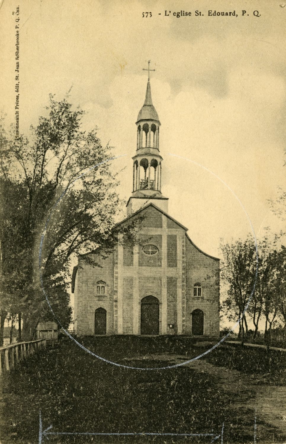 c. 1910
Public domain or CC0, made before 1950, from Wikimedia Commons; old views of places can be drawings, prints or maps of their time. Each credit opens the image’s page.
Saint-Édouard’s area holds 39 top-tier places within 25 km
By designation: 26 places classified by Québec, 17 municipal citations and 11 Recognized Federal Heritage Buildings. The earliest date is Fort Laprairie’s, 1687, 22 km away. Nearest comes Maison Nathaniel-Douglas, 6.1 km off, in Saint-Cyprien-de-Napierville.
The 12 nearest, within 25 km
| Maison Nathaniel-DouglasCited heritage site (Québec) · 6.1 km away, in Saint-Cyprien-de-Napierville |
| Cimetière DouglassCited heritage site (Québec) · 6.2 km away, in Saint-Cyprien-de-Napierville |
| Palais de justice de NapiervilleClassified heritage building (Québec) · 1834 · 9.4 km away, in Napierville |
| Chapelle-reposoir de Saint-Jacques-le-MineurClassified heritage building (Québec) · 1889 · 10 km away, in Saint-Jacques-le-Mineur |
| Église de Saint-MathieuMunicipal citation (Québec) · 1921–1922 · 10 km away, in Saint-Mathieu |
| Calvaire du cordonClassified heritage building (Québec) · 1838 · 12 km away, in Saint-Rémi |
| Maison RoyClassified heritage building (Québec) · 1835–1837 · 14 km away, in Saint-Blaise-sur-Richelieu |
| Maison du Domaine-LakefieldClassified heritage building (Québec) · 1850–1900 · 15 km away, in Saint-Blaise-sur-Richelieu |
| Ferme Joseph-RoyClassified heritage building (Québec) · 1805 · 15 km away, in Saint-Jean-sur-Richelieu |
| École de fabrique de Sainte-Marguerite-de-BlairfindieClassified heritage building (Québec) · 1831 · 17 km away, in Saint-Jean-sur-Richelieu |
| Presbytère de Sainte-Marguerite-de-BlairfindieClassified heritage building (Québec) · 1821 · 17 km away, in Saint-Jean-sur-Richelieu |
| Église Sainte-Marguerite-de-BlairfindieClassified heritage building (Québec) · 1800–1801 · 17 km away, in Saint-Jean-sur-Richelieu |
Most of what stands within 25 km of Saint-Édouard dates from the years before Confederation
Reaching 25 km out from Saint-Édouard: the historic places by their first construction date on record.
Within 25 km, building dates exist for 61 places. 48 go back before 1867. The oldest is Fort Laprairie in La Prairie, from 1687.
31% of Saint-Édouard’s homes were built before 1961
New building in Saint-Édouard runs at the usual pace: 3.9% of homes from 2016–21, the typical town 4.1%. Saint-Édouard built little from 1981 to 2000: 16% of its homes, where most towns have 23%. 18% of Saint-Édouard’s homes date from 2001 to 2015, well above the typical 15%.
2021 Census, private dwellings by period of construction (Statistics Canada); the typical town is the middle Canadian town of 2,500 or more.
Saint-Édouard and its neighbours
| Town | People | Places | Highest | Oldest |
|---|---|---|---|---|
| Saint-Édouard | 1,438 | 0 | 0 | — |
| Saint-Michel | 3,672 | 0 | 0 | — |
| Saint-Patrice-de-Sherrington | 1,996 | 0 | 0 | — |
| Saint-Jacques-le-Mineur | 1,907 | 1 | 1 | 1889 |
| Saint-Rémi | 9,557 | 1 | 1 | 1838 |
| Saint-Cyprien-de-Napierville | 1,786 | 2 | 0 | — |
| Napierville | 4,187 | 1 | 1 | 1834 |
Saint-Édouard in brief
Saint-Édouard’s homes from before 1961 come to 31%, against 18% in the typical town. The rest is about typical: its past has lives on the record such as Eugène Lafontaine (1857) and Irénée Vautrin (1888).
What this data can and can’t tell you
- Protection. In Québec, a classement or a municipal citation under the Loi sur le patrimoine culturel protects the building in law; a federal designation recognises significance and binds only federal owners.
- Québec’s register. In Québec the ministry of culture publishes its register openly: provincial classements, declared sites and the municipalities’ citations all appear, with their descriptions.
- The grade. There is no history grade: the page sets out the record and compares it with other towns.
- The federal register. Federal places come from Parks Canada’s directory, which counts National Historic Sites, federal heritage buildings, stations and lighthouses; their statements are the register’s own.
- People and events. Persons of national historic significance come with no location; a town gets one only by birthplace (name and both life years agreeing) or by one of its own places that bears the name and whose record tells the story. Events, which can’t be tied, are left out.
- The tiers. Tiers follow the designation: national recognition and classement first, other federal designations next, provincial and local listings last.
Questions about Saint-Édouard’s history
How many historic places does Saint-Édouard have on the registers?
Saint-Édouard has none of its own yet. Maison Nathaniel-Douglas, in Saint-Cyprien-de-Napierville, is the nearest, 6.1 km away.
When did Saint-Édouard become a municipality?
Wikidata gives July 1, 1855 for Saint-Édouard, which may mark incorporation or an amalgamation rather than a founding.
How old are the homes in Saint-Édouard?
31% of its homes were built before 1961, against 18% in the typical Canadian town.
Contains information licensed under the Open Government Licence – Canada (Parks Canada).
Sources: Parks Canada, Directory of Federal Heritage Designations · Canadian Register of Historic Places (federal extract) · Wikidata (CC0) for map points, other names and articles · Statistics Canada, 2021 Census (homes by period of construction). Under the Statistics Canada Open Licence.
Adapted from Statistics Canada (Census of Population 2021, population estimates 2025, 2021 census boundaries) under the Statistics Canada Open Licence; this does not constitute an endorsement by Statistics Canada. Neighbourhood names in some cities © OpenStreetMap contributors (ODbL).