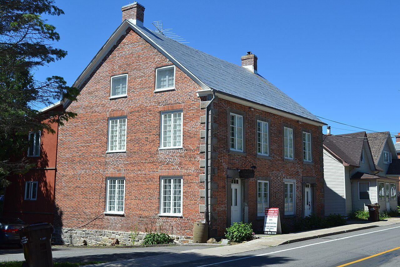
Maison Barclay · Photo: Cantons-de-l'Est · CC BY-SA 4.0
5historic places on the registers
History of Saint-André-d'Argenteuil · Canada’s heritage registers
Saint-André-d'Argenteuil has 5 historic places on the registers, 3 in the top tier
On the list: 2 Recognized Federal Heritage Buildings. Per resident Saint-André-d'Argenteuil outdoes 99% of Canadian towns, with 15 for every 10,000 people. Before 1961: 36% of the homes, where most towns have 18%. Go back to 1800 and you reach Maison Barclay, the oldest of them.
Saint-André-d'Argenteuil’s landmarks in 4 photos, with 2 old views
Photos show 4 of the places Saint-André-d'Argenteuil’s registers name; the others show their record instead. Two worth a look first: Maison Barclay and Carillon Barracks.
Photos from Wikimedia Commons, each credited to its photographer with its licence; names open the place’s page. Tap a photo to step through them full screen.
Through time
Saint-André-d'Argenteuil from 1850 to 1899
2 old photographs of the town, from oldest to latest. Swipe along the strip; each picture opens at full size.
18501875190019251950Before ConfederationConfederation to 1900Boom yearsThe wars and betweenAfter the war
Public domain or CC0, made before 1950, from Wikimedia Commons; old views of places can be drawings, prints or maps of their time. Each credit opens the image’s page.
How it began
Saint-André-d'Argenteuil’s early dates, from 1999
The municipality succeeded Carillon, Saint-André-Est and Saint-André-d'Argenteuil in 1999. Wikidata holds December 29, 1999 as the start of the municipality of Saint-André-d'Argenteuil, a date that can just as well be an incorporation. The name Saint-André-Carillon lasted until 2000, when Saint-André-d'Argenteuil took another.
Every place on the registers inside the town, by its designation.
Highest designationsOther federal designations
Each dot is a place: point at it for the name, tap it for its page.
The 5, by tier
3 Highest designations2 Other federal designations
Federal designations come from Parks Canada; Québec’s own register adds what the province has classified and what the municipality has cited.
Points from Wikidata (Parks Canada’s files carry none) and from Québec’s register, as mapped there.
Highest designations
3 places in Saint-André-d'Argenteuil with the highest designation
Designations came from 1960 to 1985. Here that means 2 places classified by Québec and a National Historic Site. National Historic Sites and Classified Federal Heritage Buildings, Canada’s highest federal recognition. Each one opens its own page.
Federal heritage in Saint-André-d'Argenteuil: 2 more places
Recognized Federal Heritage Buildings, heritage railway stations and lighthouses. They include Collector's House and Superintendent's Residence. Each one opens its own page.
60% of Saint-André-d'Argenteuil’s historic places are houses
The first by rank are Carillon Barracks and Maison Barclay.
Houses3
Forts and military buildings1
Churches and religious buildings1
Kinds read from each place’s name and the functions its register gives; a building keeps the kind it was built as.
Just outside
Just outside Saint-André-d'Argenteuil
Places the registers give to the town from within 5 km of its edge, nearest first.
Just outside Saint-André-d'Argenteuil: 1
Carillon CanalNational Historic Site · 100 m outside the town
Homes by age
36% of Saint-André-d'Argenteuil’s homes were built before 1961
More than half of Saint-André-d'Argenteuil’s housing predates 1981. From 2016 to 2021 Saint-André-d'Argenteuil added 3.9% of its homes, close to the typical town’s 4.1%. In Saint-André-d'Argenteuil, 25% of homes date from 1961 to 1980, much as in most towns (27%).
36%
Before 1961
25%
1961–80
20%
1981–2000
15%
2001–15
3.9%
2016–21
Saint-André-d'ArgenteuilTypical town
2021 Census, private dwellings by period of construction (Statistics Canada); the typical town is the middle Canadian town of 2,500 or more.
Born here
John Abbott and 3 others: Saint-André-d'Argenteuil’s people of the past
Nathanael Burwash reached 79, the longest life here, ending in 1918. The federal list of national historic persons names John Abbott. At the other end is Maude Abbott, from 1868. John Abbott comes first, born in 1821.
John Abbott
Nathanael Burwash
François-Xavier Brunet
Maude Abbott
1800182518501875190019251950
John Abbott1821–1893 · Designated nationally in 1938 · 3rd Prime Minister of Canada
Maude Abbott1868–1940 · Canadian physician
François-Xavier Brunet1868–1922 · Catholic bishop
NB
Nathanael Burwash1839–1918 · Canadian minister and theologian
Everyone born in Saint-André-d'Argenteuil → Born before 1914. Birthplaces from Wikidata, each checked against Wikipedia; national historic persons from Parks Canada’s Directory of Federal Heritage Designations, matched by name and life years.
Towns its size
Saint-André-d'Argenteuil has the 2nd most of 16 towns its size
Towns of 3,300 to 3,300 residents, by places on the registers.
Older stock first: 36% of homes in Saint-André-d'Argenteuil were standing by 1961, against 18% in the typical town. There are 5 historic places in all, 3 with the highest designation. Only one of the 16 towns nearest its size has more historic places. John Abbott (1821), Maude Abbott (1868) and François-Xavier Brunet (1868) lead its people of the past. The rest is about typical: most dated places belong to the years before Confederation; and the designations ran from 1960 to 1990.
How to read these numbers
What this data can and can’t tell you
•
The grade. History is described, not graded, for every Canadian town.
•
Protection. Here the register is also the protection: classement and citation under Québec’s cultural heritage law control changes, while federal recognition does not.
•
The tiers. Three tiers: the top for National Historic Sites, classified federal buildings and Québec’s classements, a second for the other federal designations, a third for provincial and municipal listings.
•
Map points. Where a federal place sits on the map is Wikidata’s placing; the directory itself has no coordinates.
•
People and events. The open directory puts its national historic persons nowhere, so a town shows one only on firm ground: a birth there, matched by name and life years, or a historic place there named for the person whose record says so. Events are left out.
•
Québec’s register. Québec’s Répertoire du patrimoine culturel records the province’s classements and declarations and every municipal citation, each with a description and a point.
•
The federal register. Parks Canada’s Directory of Federal Heritage Designations lists every National Historic Site, federal heritage building, heritage railway station and lighthouse; the Canadian Register of Historic Places adds their statements in English and French.
Questions about Saint-André-d'Argenteuil’s history
How old are the homes in Saint-André-d'Argenteuil?
36% of its homes were built before 1961, against 18% in the typical Canadian town.
Which places in Saint-André-d'Argenteuil have the highest designation?
Carillon Barracks, Maison Barclay and Église Christ Church de Saint-André-d'Argenteuil.
What is the oldest building in Saint-André-d'Argenteuil?
By its record, Maison Barclay, from 1800 (Classified heritage building (Québec)).
Contains information licensed under the Open Government Licence – Canada (Parks Canada). Québec register data: Ministère de la Culture et des Communications du Québec, CC BY 4.0.
Sources: Parks Canada, Directory of Federal Heritage Designations · Canadian Register of Historic Places (federal extract) · Répertoire du patrimoine culturel du Québec (MCC, Données Québec) · Wikidata (CC0) for map points, other names and articles · Statistics Canada, 2021 Census (homes by period of construction). Under the Statistics Canada Open Licence.


 1850
 c. 1899
 Top
 Top
 Top
 Fed


