 Photo: Quintin Soloviev · CC BY 4.0
Within 50 km of Pessamit, 13 places are on the heritage registers
2 old photographs show Pessamit between 1920 and 1942. Look 44 km away, to Baie-Comeau, for the nearest place of the highest designation.
Pessamit through the years, 1920–1942
On one line by date: 2 old photographs of the town. Tap any picture to see it full screen.
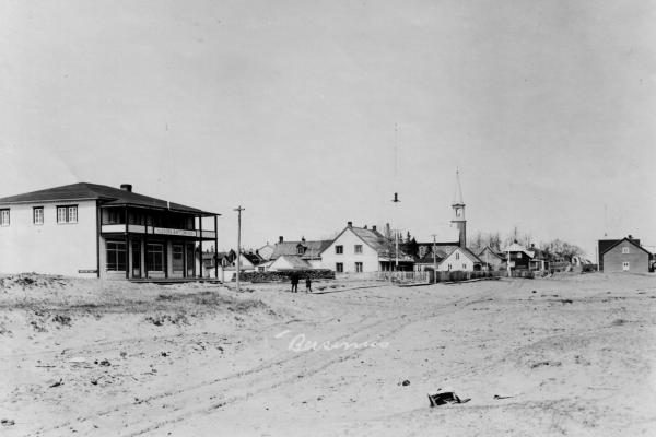 c. 1920
 1942
Public domain or CC0, made before 1950, from Wikimedia Commons; old views of places can be drawings, prints or maps of their time. Each credit opens the image’s page.
13 designated places lie within 50 km of Pessamit
They belong to 5 towns, chiefly Sainte-Luce, Mont-Joli and Rimouski. The first one out is Arboriduc de Forestville, 38 km away in Forestville. For the highest designations, the nearest of 5 is Site patrimonial des Tours-de-Guet-de-Sainte-Flavie, 48 km away.
The 12 nearest, within 50 km
| Arboriduc de ForestvilleMunicipal citation (Québec) · 1942–1943 · 38 km away, in Forestville |
| La Petite Anglicane de ForestvilleMunicipal citation (Québec) · 1948 · 38 km away, in Forestville |
| Site patrimonial des Tours-de-Guet-de-Sainte-FlavieClassified heritage site (Québec) · 1940–1942 · 48 km away, in Sainte-Luce |
| Church of St AmeliaClassified heritage building (Québec) · 1939–1940 · 48 km away, in Baie-Comeau |
| West WatchtowerMunicipal citation (Québec) · 1940–1942 · 48 km away, in Sainte-Luce |
| Site de l'église et du cimetière de Sainte-LuceCited heritage site (Québec) · 48 km away, in Sainte-Luce |
| Sainte-Luce ChurchClassified heritage building (Québec) · 1838–1840 · 48 km away, in Sainte-Luce |
| Site du patrimoine Flavie-DrapeauCited heritage site (Québec) · 48 km away, in Mont-Joli |
| Ancien presbytère de Sainte-FlavieMunicipal citation (Québec) · 1853 · 48 km away, in Mont-Joli |
| East watchtowerMunicipal citation (Québec) · 1940–1942 · 49 km away, in Mont-Joli |
| Fog Alarm BuildingRecognized Federal Heritage Building · 1903–1904 · 49 km away, in Rimouski |
| Light TowerClassified Federal Heritage Building · 1909–1910 · 49 km away, in Rimouski |
The places within 50 km of Pessamit lean to the wars and the Depression
The nearest historic places to Pessamit, out to 50 km, by the first construction date on each record.
Within 50 km, 11 records give a date. 3 go back before 1867. Sainte-Luce Church, in Sainte-Luce, goes back furthest, to 1838.
Few of Pessamit’s homes are older than 1961: 10%, against 18%
Half of the homes standing in Pessamit today were built before 2001. New building is strong in Pessamit: 7.3% of homes date from 2016–21, where most towns have 4.1%. The busiest building years in Pessamit were from 1981 to 2000, which account for 35% of today’s homes.
2021 Census, private dwellings by period of construction (Statistics Canada); the typical town is the middle Canadian town of 2,500 or more.
Pessamit in brief
The census dates only 10% of its homes before 1961, against 18% in the typical town. Everything else is close to the norm: like most towns its size, it has no historic place.
What this data can and can’t tell you
- People and events. National historic persons carry no place in the open file. They appear on a town’s page when born there (same name, same birth and death years) or when a historic place inside it carries their name and its record names them with their dates; national historic events don’t appear.
- The tiers. Three tiers: the top for National Historic Sites, classified federal buildings and Québec’s classements, a second for the other federal designations, a third for provincial and municipal listings.
- The grade. History is described, not graded, for every Canadian town.
- Protection. Here the register is also the protection: classement and citation under Québec’s cultural heritage law control changes, while federal recognition does not.
- The federal register. The federal list is complete and open: Parks Canada’s directory for the designations, the Canadian Register of Historic Places for what each one is and why it matters.
- Québec’s register. Québec is the one province whose register is open: classements, declarations and municipal citations, described by the ministry in French.
Questions about Pessamit’s history
How many historic places does Pessamit have on the registers?
The registers have nothing inside Pessamit; Arboriduc de Forestville, in Forestville, is 38 km away.
How old are the homes in Pessamit?
10% of its homes were built before 1961, against 18% in the typical Canadian town.
Contains information licensed under the Open Government Licence – Canada (Parks Canada).
Sources: Parks Canada, Directory of Federal Heritage Designations · Canadian Register of Historic Places (federal extract) · Wikidata (CC0) for map points, other names and articles · Statistics Canada, 2021 Census (homes by period of construction). Under the Statistics Canada Open Licence.
Adapted from Statistics Canada (Census of Population 2021, population estimates 2025, 2021 census boundaries) under the Statistics Canada Open Licence; this does not constitute an endorsement by Statistics Canada. Neighbourhood names in some cities © OpenStreetMap contributors (ODbL).