
South Eglinton-DavisvilleToronto
It is one of the 158 neighbourhoods that make up Toronto. 23,380 residents make their home in this neighbourhood in Toronto.
Is South Eglinton-Davisville a good place to live?
The everyday basics are strong; the price of a home is the catch. On schools it is strong (A+). What counts against it is cost of living (D−). Overall, that makes an A, good for #67 of 858 in Ontario. Nationally, it does better than 86% of Canadian towns.
Rents here are the metro area's average, shared by every town and neighbourhood in it. Safety uses the city's Crime Severity Index, scaled by this neighbourhood's own violent and property crime rates. Health is graded on the health region's survey figures and life expectancy, with the distance to hospital giving the town its own spread.
What makes South Eglinton-Davisville stand out
The 3 things South Eglinton-Davisville does most differently from other towns.
How South Eglinton-Davisville grades
Each subject compares South Eglinton-Davisville with Canadian towns of 2,500 or more, ordered by how far it is from the middle. Towns in other countries are graded separately.
How TownRatings grades Canadian towns →
Avant Garde and 63 more in and around South Eglinton-Davisville
The best-known places to visit in and around South Eglinton-Davisville come first; the full list is on the Attractions page.
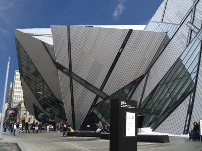 Big drawMuseumRoyal Ontario Museum3.2 km outside town, to the south · 281.4M visitors a year (2025)
 Big drawArt galleryArt Gallery of Ontario4.8 km outside town, to the south · 873K visitors a year (2016)
 Historic houseCasa Loma2.3 km outside town, to the south
 MuseumBata Shoe Museum3.3 km outside town, to the south
 CathedralSt. Michael's Cathedral4.9 km outside town, to the southeast
Photos: each place’s Wikidata image, from Wikimedia Commons under the licence below (our copy, resized).
Photo credits (5)
- Royal Ontario Museum: Staka, CC BY-SA 4.0, Wikimedia Commons
- Art Gallery of Ontario: Owen Byrne from Ottawa, Canada, CC BY 2.0, Wikimedia Commons
- Casa Loma: Evelyncyuzu, CC BY-SA 4.0, Wikimedia Commons
- Bata Shoe Museum: Gisling, CC BY-SA 3.0, Wikimedia Commons
- St. Michael's Cathedral: Oleg Yunakov, CC BY-SA 4.0, Wikimedia Commons
The data
Data highlights are ordered by what stands out in South Eglinton-Davisville.
Renting in South Eglinton-Davisville eats 31% of household income, more than in Ontario’s towns or Canadian towns
The median home value was $750,000, above both Ontario’s towns ($695,000) and Canadian towns ($406,000). Shelter took 30% or more of income for just over two in five households, above both Ontario’s towns (22%) and Canadian towns (18%).
What homes were worth · The median owner’s estimate at the 2021 census
| Census 2021 | South Eglinton-Davisville | Ontario | Canada |
|---|---|---|---|
| Households spending 30%+ on shelter | 42% | 22% | 18% |
| Rent as a share of income | 31% | 22% | 20% |
| Median home value, 2021 | $750,000 | $695,000 | $406,000 |
Statistics Canada, Census 2021; CMHC Rental Market Survey via Statistics Canada · These are 2021 census values, as owners judged them, set against household income in 2020. · Rent as a share of income and monthly rent for a two-bedroom: the Toronto metro area
South Eglinton-Davisville has 18 of its 40 tested schools in the top fifth in Ontario
Catholic schools are fewer here, 7 of 43, where in Ontario they are 34%. Northern Secondary School is the biggest, at 2,075 students. The schools around it answer to 2 boards, below both Ontario’s towns (4) and Canadian towns (3). No French-language school is among them; in Ontario, 10% of schools are.
| School | Level | Students | System |
|---|---|---|---|
| Northlea Elementary and Middle School Top fifth in OntarioLargest elementary schoolElementary · Grades JK–8 | Elementary · Grades JK–8 | 745 | English public |
| Northern Secondary School Second fifth in OntarioLargest secondary schoolSecondary · Grades 9–12 | Secondary · Grades 9–12 | 2,075 | English public |
| Cottingham Junior Public School Top fifth in OntarioResults in the top fifth in OntarioElementary · Grades JK–6 | Elementary · Grades JK–6 | 140 | English public |
Schools by system · Schools within 3 km
| Schools within 3 km | South Eglinton-Davisville | Ontario | Canada |
|---|---|---|---|
| School boards | 2 | 4 | 3 |
Provincial school lists and results, 2024-25
South Eglinton-Davisville’s grade for safety: an A
The Crime Severity Index, Violent Crime Severity Index, violent crime and property crime per 1,000 numbers here cover the Toronto service area
For violence alone, its police area’s index was 93, above both Ontario’s towns (76) and Canadian towns (86). Where it is policed, thefts, break-ins and damage came to 34.4 per 1,000 a year, higher than both Ontario’s towns (30.5) and Canadian towns (31.2).
Year by year · Crime Severity Index for each year
| 2023–2025 | South Eglinton-Davisville | Ontario | Canada |
|---|---|---|---|
| Violent Crime Severity Index | 93 | 76 | 86 |
| Property crime per 1,000 | 34.4 | 30.5 | 31.2 |
Statistics Canada, Uniform Crime Reporting Survey, 2023–2025 average
Few places match South Eglinton-Davisville for health: it beats 90% of Canadian towns
Area-wide: health survey and life expectancy, counted over the City of Toronto Health Unit
The survey finds 50% of adults in very good or excellent health, close to Ontario’s towns (51%) and below Canadian towns (52%). The region’s 2022/2024 life expectancy is 84.7, with women at 87.2 and men at 82.0. At 9.2%, the share of adults who smoke sits under the 11% for Ontario. Closer to home, a hospital is just 1.0 km from the average resident of South Eglinton-Davisville, nearer than the usual 3.7 km.
Very good or excellent health · adults, age-standardised
| Health | South Eglinton-Davisville | Ontario | Canada |
|---|---|---|---|
| Life expectancy at birth | 84.7 | 82.8 | 81.5 |
| Smokers | 9.2% | 10% | 12% |
| Chronic conditions (average share) | 16% | 17% | 17% |
| Very good or excellent health | 50% | 51% | 52% |
Statistics Canada, Canadian Community Health Survey 2023/2024 and life expectancy 2022/2024; Open Database of Healthcare Facilities
A quiet place for hazards: low wildfire, little earthquake risk, and 2.7% of tested homes over the radon guideline in South Eglinton-Davisville’s area
Seismic risk in South Eglinton-Davisville sits near the middle: $0.043 of expected damage per $1,000 of buildings a year, the typical town $0.030. No flood study for South Eglinton-Davisville is on the national inventory. For earthquake risk, the only official count covers all of the city of Toronto, South Eglinton-Davisville included.
Radon tests above the guideline · share of tested homes, 200 Bq/m³
| Hazards | South Eglinton-Davisville | Ontario | Canada |
|---|---|---|---|
| Radon tests above the guideline | 2.7% | 4% | 6.6% |
| Earthquake loss per $1,000 of buildings a year | $0.043 | $0.043 | $0.030 |
NRCan seismic risk model and burned areas, Health Canada radon survey, the Flood Hazard Map Inventory
Trips to work from South Eglinton-Davisville take longer than from Ontario’s towns or Canadian towns: 33 min on average
How working residents got to work · census 2021
| Census 2021 | South Eglinton-Davisville | Ontario | Canada |
|---|---|---|---|
| Average trip | 33 min | 29 min | 26 min |
Statistics Canada, Census 2021 (labour and commuting) · These are May 2021 figures, gathered while COVID-19 kept many people home or out of work.
Frost comes to South Eglinton-Davisville less often than to 89% of Canadian towns
The frost-free season runs from 11 April to 6 November, 208 days. Winter lows average −6.7°C in January, above both Ontario’s towns (−9.1°C) and Canadian towns (−13.5°C). Most of the snow comes in January, about 40 cm. June is the wettest month, with 82 mm of rain and snow on average.
Average high by season · ECCC normals, 1991–2020
| Normals, 1991–2020 | South Eglinton-Davisville | Ontario | Canada |
|---|---|---|---|
| Days with frost a year | 101 | 139 | 159 |
| January night low | −6.7°C | −9.1°C | −13.5°C |
| July afternoon high | 27.0°C | 26.7°C | 25.5°C |
| Precipitation a year | 823 mm | 902 mm | 883 mm |
Environment and Climate Change Canada, Canadian Climate Normals 1991–2020 (Toronto (City))
Children make up only 9.4% of South Eglinton-Davisville, fewer than in Ontario’s towns and Canadian towns
People 65 and over make up 16% of the town, below both Ontario’s towns (19%) and Canadian towns (19%). Visible minorities make up 46% of the population, higher than both Ontario’s towns (26%) and Canadian towns (15%).
Ages · Share of residents in each age group, Census 2021
Schooling · Highest qualification, residents 15 and over
Women and men · all residents
54.0% of South Eglinton-Davisville’s residents are women
The 2021 census counted 12,610 women and 10,760 men here, where women make up 50.9% of Canada.
| South Eglinton-Davisville | Ontario | Canada | |
|---|---|---|---|
| Under 15 | 9.4% | 15% | 16% |
| 15 to 64 | 75% | 65% | 64% |
| 65+ | 16% | 19% | 19% |
| No certificate, diploma or degree | 4.4% | 15% | 16% |
| Postsecondary qualification | 82% | 56% | 56% |
Statistics Canada, Census 2021; Ontario and Canada: medians of towns of 2,500+
South Eglinton-Davisville in November: highs near 8°C, lows near 2°C
The forecast on the Weather page is ECCC’s for Toronto. A normal December brings highs of 3°C, lows of −3°C. Snowfall in a normal November: 12 cm. Precipitation in November averages 71 mm.
Normal highs, the months ahead · ECCC normals, 1991–2020
| Season | High | Low | Rain and snow |
|---|---|---|---|
| Winter | 1°C | −5°C | 176 mm |
| Spring | 12°C | 4°C | 207 mm |
| Summer | 26°C | 17°C | 230 mm |
| Autumn | 15°C | 8°C | 209 mm |
ECCC normals, 1991–2020 (Toronto (City)); the forecast is on the Weather page
No public library stands in South Eglinton-Davisville: the closest, Toronto Public Library - Mount Pleasant, is 0.5 km away
Toronto public library serves the whole of Toronto, so the library figures on this page are the city’s: 3,110,984 people, South Eglinton-Davisville among them.
Provincial library statistics, OpenStreetMap, the CRA and Statistics Canada
A national park 20 km from South Eglinton-Davisville: Rouge National Urban Park
Biggest among them: E.T. Seton Park, 130 ha, 2.9 km off. A provincial park, Bronte Creek Provincial Park, lies 43 km away. Walkers have 2 mapped routes close by, starting with the Central Ravines, Belt Line & Gardens Discovery Walk and Northern Ravines & Gardens Discovery Walk. One unnamed beach is mapped within 5 km.
Protected land · of the land within 10 km
| Outdoors | South Eglinton-Davisville | Ontario | Canada |
|---|---|---|---|
| Protected land within 10 km | 2.7% | 2.3% | 2.3% |
| Public protected areas within 10 km | 5 | 4 | 4 |
Canadian Protected and Conserved Areas Database (CPCAD), OpenStreetMap routes and beaches
Everything we know about South Eglinton-Davisville
South Eglinton-Davisville’s neighbours
The nearest places of 1,000 or more. Statistics Canada
| Town | People | km | Overall | Cost | Safety | Health |
|---|---|---|---|---|---|---|
| South Eglinton-Davisville | 23,380 | — | A | D− | A | A |
| Yonge-Eglinton | 12,424 | 0.7 | A− | D− | B− | A |
| North Toronto | 16,007 | 0.9 | A− | D− | A− | A |
| Mount Pleasant East | 16,373 | 0.9 | A | D | A | A |
| Yonge-St.Clair | 13,177 | 1.5 | A | D− | A | A |
| Lawrence Park South | 15,018 | 1.7 | A | C+ | B+ | A |
| Forest Hill South | 11,059 | 2.1 | A− | D | B− | A |
People: Statistics Canada, Census 2021. Distances: centre to centre.
Questions about South Eglinton-Davisville
Is South Eglinton-Davisville a young town or an old one?
At 37, its median age compares with 45.2 across Canadian towns. Children make up 9% of the population and seniors 16%.
About South Eglinton-Davisville
Neighbourhood in Toronto
The edges of South Eglinton-Davisville follow census dissemination areas, which TownRatings groups into Toronto’s neighbourhoods; the name comes from the city’s map or OpenStreetMap.
Statistics Canada: population estimates 2025 (17-10-0155), Census of Population 2021, 2021 census boundaries.
- Population
- 23,380 (people, 2021 estimate)
- Province or territory
- Ontario
- City
- Toronto
- Census subdivision
- 3520005
Sources: Statistics Canada, Census of Population 2021 · population estimates 2025 (17-10-0155) and 2021 census boundaries · Uniform Crime Reporting Survey 2023–25 (35-10-0026, 35-10-0183 to 35-10-0190) · CMHC rents as published by Statistics Canada (34-10-0133) · grades by TownRatings. Under the Statistics Canada Open Licence.
Adapted from Statistics Canada (Census of Population 2021, population estimates 2025, 2021 census boundaries) under the Statistics Canada Open Licence; this does not constitute an endorsement by Statistics Canada. Neighbourhood names in some cities © OpenStreetMap contributors (ODbL).