 Top
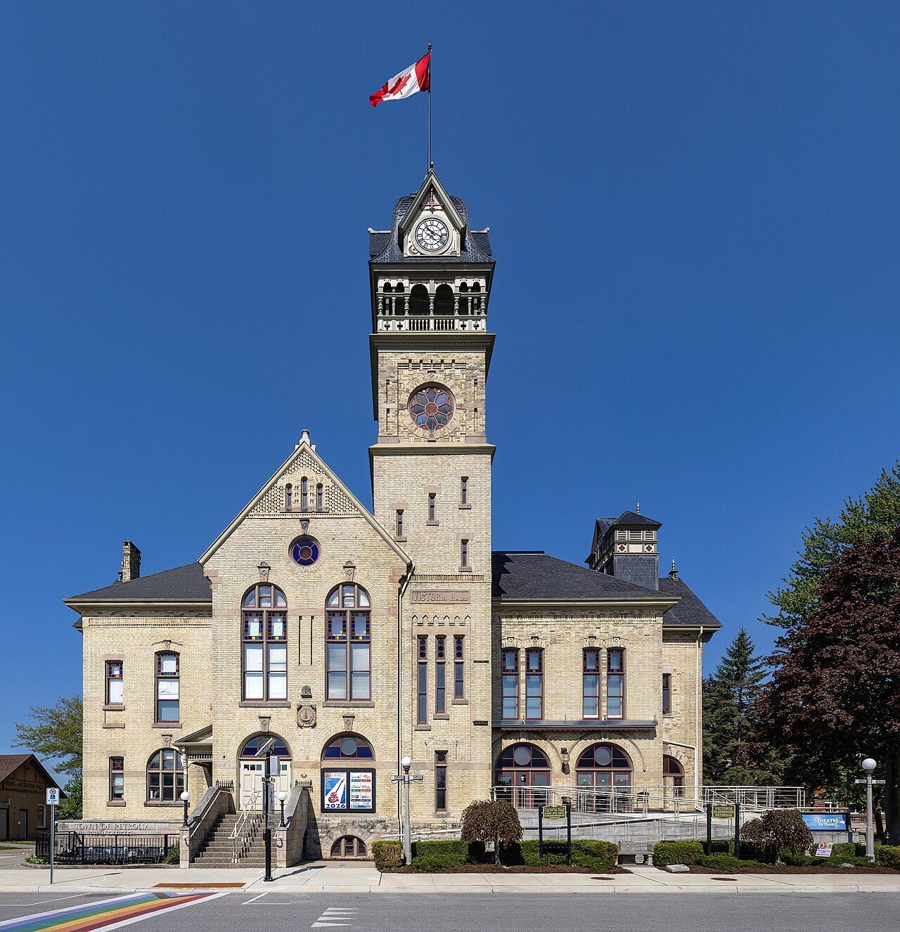
National Historic Site · 1887–1890Victoria Hall / Petrolia Town Hall411 Greenfield StreetPhoto: Chris Woodrich · CC BY-SA 4.0 · Commons file
 Photo: P199 · CC BY-SA 3.0
1historic place on the registers
History of Petrolia · Canada’s heritage registers
Petrolia’s 1 historic place is a top designation
Older housing stands out in Petrolia: 33% of homes predate 1961, where the typical town has 18%. Victoria Hall / Petrolia Town Hall, from 1887, is the town’s national historic site. As a municipality it dates, by Wikidata, from 1866, a date that can mark incorporation or a merger as well as a founding. For every 10,000 residents Petrolia has 1.6, ahead of 83% of Canadian towns.
Historic places
1
1.6 per 10,000 residents
Highest designations
1
National Historic Sites and Classified Federal Heritage Buildings
Oldest building
1887
the first construction date on its record
Homes built before 1961
33%
typical town: 18%
In pictures
A look at historic Petrolia
One place in Petrolia is on the registers, and this is it: Victoria Hall / Petrolia Town Hall.
Photos from Wikimedia Commons, each credited to its photographer with its licence; names open the place’s page. Tap a photo to step through them full screen.
Through time
Looking back at Petrolia
The oldest view of one of its historic places, made before 1950. Open it full screen with a tap.
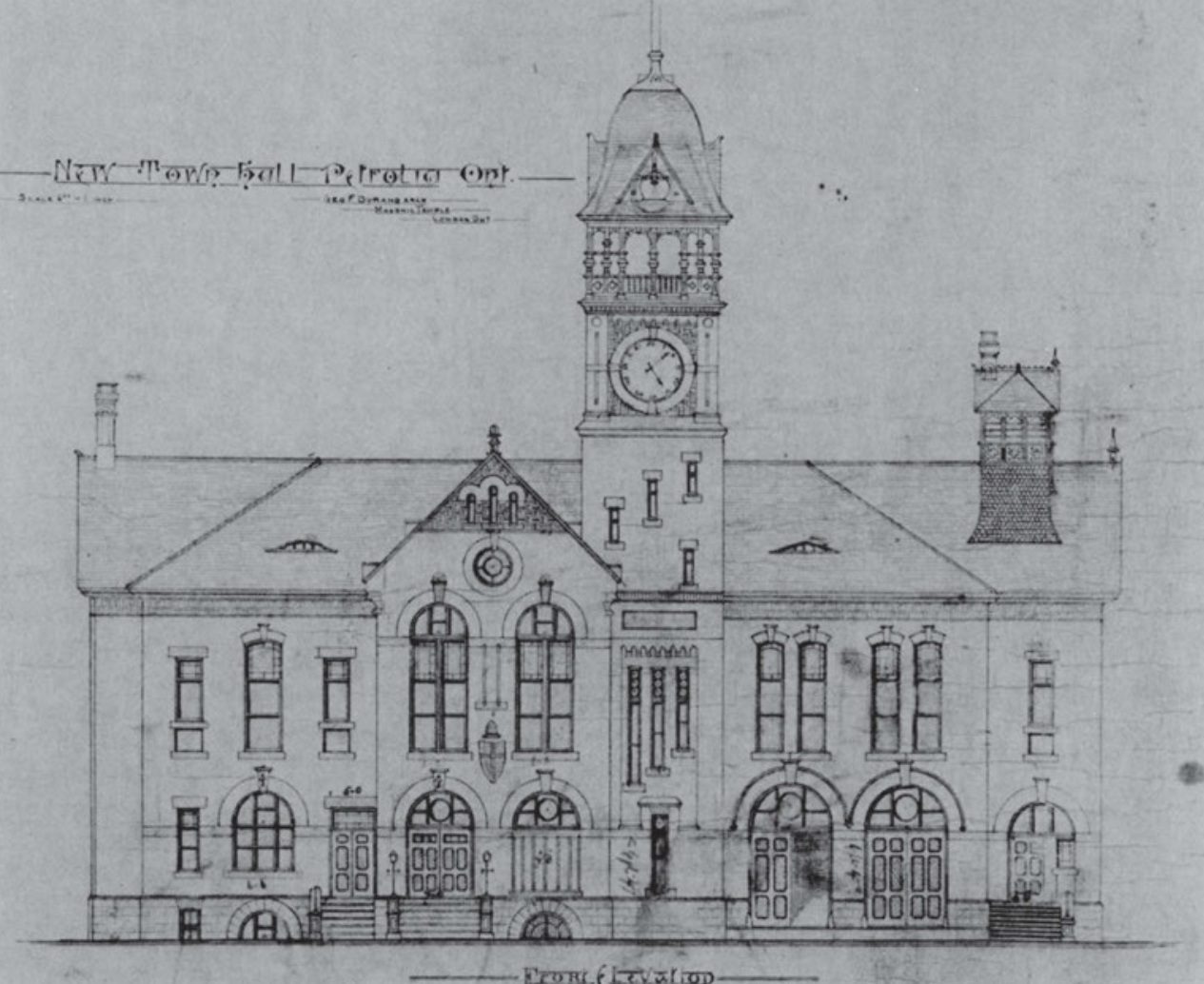 c. 1887
Public domain or CC0, made before 1950, from Wikimedia Commons; old views of places can be drawings, prints or maps of their time. Each credit opens the image’s page.
The map
Where Petrolia’s history is
Every place on the registers inside the town, by its designation.
Highest designations
Hover a dot for its name; tap one to open its page.
The 1, by tier
1 Highest designations
Parks Canada’s Directory of Federal Heritage Designations lists the places the Government of Canada has recognized; outside Québec, provincial and municipal listings come only through Wikidata, and only those with an encyclopedia article get a page.
Points from Wikidata (Parks Canada’s files carry none) and from Québec’s register, as mapped there.
Highest designations
One place in Petrolia with the highest designation
National Historic Sites and Classified Federal Heritage Buildings, Canada’s highest federal recognition. Each one opens its own page.
Around the town
The registers find 7 places within 50 km of Petrolia
Their towns number 6: Walpole Island 46, Enniskillen and Sarnia first. The nearest is First Commercial Oil Field, 11 km away in Enniskillen. By age, Fairfield on the Thames leads, from 1792, at 38 km.
The 7 nearest, within 50 km
| First Commercial Oil FieldNational Historic Site · 1858–1859 · 11 km away, in Enniskillen |
| VIA Rail Station, Sarnia, OntarioHeritage Railway Station · 1891–1892 · 21 km away, in Sarnia |
| Fairfield on the ThamesNational Historic Site · 1792–1793 · 38 km away, in Chatham |
| Walpole Island Upper A34 LighthouseHeritage Lighthouse · 1929 · 41 km away, in Walpole Island 46 |
| Battle HillNational Historic Site · 1814 · 42 km away, in Glencoe |
| Walpole Island Lower A32 LighthouseHeritage Lighthouse · 1931 · 42 km away, in Walpole Island 46 |
| ParkhillNational Historic Site · 48 km away, in Parkhill |
Homes by age
A growing town: 6.5% of Petrolia’s homes went up from 2016 to 2021, against 4.1%
18% of Petrolia’s homes were built from 2001 to 2015, more than the typical town’s 15%. Half of the homes standing in Petrolia today were built before 1981. Building from 1961 to 1980 gave Petrolia 22% of its homes, near the usual 27%.
33%
Before 1961
22%
1961–80
20%
1981–2000
18%
2001–15
6.5%
2016–21
PetroliaTypical town
2021 Census, private dwellings by period of construction (Statistics Canada); the typical town is the middle Canadian town of 2,500 or more.
Towns its size
Petrolia has the 1st most of 16 towns its size
Towns of 6,400 to 6,500 residents, by places on the registers.
Petrolia1
The typical town its size has 0. 14 of them have none.
Neighbours
Petrolia and its neighbours
| Town | People | Places | Highest | Oldest |
|---|---|---|---|---|
| Petrolia | 6,422 | 1 | 1 | 1887 |
| Enniskillen | 3,174 | 0 | 0 | — |
| Plympton-Wyoming | 9,548 | 0 | 0 | — |
In brief
Petrolia in brief
Housing in Petrolia includes 33% built before 1961, against 18% in the typical town. There are 1 historic place in all, one with the highest designation; Victoria Hall / Petrolia Town Hall heads them. No town its size has more historic places: it leads the 16 nearest in population. Beyond that, its past has lives on the record such as Donald Ferguson Brown (1903) and Charles Oliver Fairbank (1904); and its designation dates from 1975.
How to read these numbers
What this data can and can’t tell you
- The grade. History is described, not graded, for every Canadian town.
- The tiers. Three tiers: the top for National Historic Sites, classified federal buildings and Québec’s classements, a second for the other federal designations, a third for provincial and municipal listings.
- Protection. Federal recognition isn’t a planning control: buildings the federal government owns follow its heritage policy, while others are protected only by a provincial or municipal designation.
- The federal register. The federal list is complete and open: Parks Canada’s directory for the designations, the Canadian Register of Historic Places for what each one is and why it matters.
- Provincial and municipal lists. Provincial and municipal listings here come from Wikidata alone, since the provinces’ own registers can’t be reused; a listing needs an encyclopedia article to get a page.
- Map points. Parks Canada publishes no coordinates, so federal places are pinned where Wikidata puts them.
- People and events. National historic persons carry no place in the open file. They appear on a town’s page when born there (same name, same birth and death years) or when a historic place inside it carries their name and its record names them with their dates; national historic events don’t appear.
Questions about Petrolia’s history
How old are the homes in Petrolia?
33% of its homes were built before 1961, against 18% in the typical Canadian town.
Which places in Petrolia have the highest designation?
Just one: Victoria Hall / Petrolia Town Hall.
What is the oldest building in Petrolia?
Victoria Hall / Petrolia Town Hall — its record dates it to 1887 (National Historic Site).
Why might a heritage building in Petrolia be missing here?
Provincial and municipal registers outside Québec aren’t open data. Wikidata knows 3 more listings in Petrolia, but without an open description or an encyclopedia article they get no page.
Contains information licensed under the Open Government Licence – Canada (Parks Canada).
Sources: Parks Canada, Directory of Federal Heritage Designations · Canadian Register of Historic Places (federal extract) · Wikidata (CC0) for map points, other names and articles · Statistics Canada, 2021 Census (homes by period of construction). Under the Statistics Canada Open Licence.
Adapted from Statistics Canada (Census of Population 2021, population estimates 2025, 2021 census boundaries) under the Statistics Canada Open Licence; this does not constitute an endorsement by Statistics Canada. Neighbourhood names in some cities © OpenStreetMap contributors (ODbL).