Attractions in Riverside Park - Mooneys Bay St. Elias Antiochian Orthodox Cathedral is Riverside Park - Mooneys Bay’s place to visit Of the 41 places to visit in and around Riverside Park - Mooneys Bay, 28 are museums or galleries. The neighbourhood outline itself has one place on our list; 40 others are within 5 km of its edge. One of them is cared for by Parks Canada. If you have a day, head to National Gallery of Canada, 7 km away.
Photo: Carleton University, Harleyd613 (CC BY-SA 4.0) In Riverside Park - Mooneys Bay
1
inside the neighbourhood outline
Within 5 km
40
of the town’s edge
Museums & galleries
28
in or near town
Forts & historic sites
8
in or near town
Cared for
1
by Parks Canada
Best known
Must-know places in Riverside Park - Mooneys Bay Each has a page of its own: what it is, who runs it, the weather month by month and what else is near it.
1 2 3 4 5 6 7 8 9 10 11 12 13 14 15 16 17 18 19 20 The dashed line is Riverside Park - Mooneys Bay’s neighbourhood outline; orange marks its middle (where most people live). Numbers match the list below. © OpenStreetMap contributors · Statistics Canada 2021 outline
By kind
What sort of places Museums & galleries 20 museums · 8 art galleries 0 in town · 28 nearby
Forts & historic sites 4 historic sites · 2 cathedrals · 2 national historic sites 1 in town · 7 nearby
Gardens & estates 1 garden 0 in town · 1 nearby
Nature & national parks 1 waterfall · 1 viewpoint 0 in town · 2 nearby
Zoos, theme parks & days out 1 zoo · 1 water park 0 in town · 2 nearby
Green: inside Riverside Park - Mooneys Bay. Grey: within 5 km of its edge.
Run by Parks Canada: Commissariat Building.
Every place All the places to visit One in town leads, with 40 more within 5 km of its edge after it.
All 41 Museums & galleries 28 Forts & historic sites 8 Gardens & estates 1 Nature & national parks 2 Zoos, theme parks & days out 2
Cathedral 1 Cathedral · in town Church in Ontario, Canada.
2 Museum · 600 m outside town, to the northwest University in Ottawa, Ontario, Canada.
3 Museum · 3.3 km outside town, to the north Natural history museum in Ottawa, Canada.
Run by Government of Canada · Open Mon–Wed, Fri–Sun 09:00–18:00 · Thu 09:00–20:00 4 Museum · 4.4 km outside town, to the northwest National museum in Ontario, Canada.
5 Museum · 4.5 km outside town, to the northwest Museum in Ottawa, Ontario.
Open Every day 10:00–17:00 6 Zoo · 1.3 km outside town, to the northwest Agricultural museum in Ottawa, Ontario, Canada.
Open Every day 09:00–17:00 7 Waterfall · 100 m outside town, to the west Artificial Waterfalls in Ottawa, Ontario.
8 Viewpoint · 4.7 km outside town, to the northwest Waterfalls on the Ottawa River.
9 Garden · 2 km outside town, to the northwest Park in Ottawa, Ontario, Canada.
Run by National Capital Commission 10 Cathedral · 4.2 km outside town, to the northwest Anglican cathedral in Ottawa, Ontario, Canada.
11 Art gallery · 4.8 km outside town, to the north Art museum in Ottawa, Ontario, Canada.
Open Sun, Tue 10:00–18:00 · Wed–Sat 10:00–21:00 12 Art gallery · 4.6 km outside town, to the northwest In Ottawa, Ontario.
13 Museum · 4.9 km outside town, to the northwest Run by Parks Canada 14 National historic site · 2 km outside town, to the northwest Museum 15 Museum · 4.4 km outside town, to the northwest War art collection of the Canadian War Museum.
Run by Canadian War Museum 16 National historic site · 4.8 km outside town, to the northwest Museum 17 Museum · 1.5 km outside town, to the north Art gallery 18 Art gallery · 2.9 km outside town, to the northwest Open Tue–Sat 13:00–17:00 Museum 19 Museum · 4.2 km outside town, to the southwest Art gallery 20 Art gallery · 3.6 km outside town, to the northwest Museum Museum · 4.4 km outside town, to the northwest Open Every day 09:30–16:30 Museum Museum · 4.6 km outside town, to the north Open Mon–Fri 10:00–16:00 Museum Museum · 4.1 km outside town, to the northwest Museum Museum · 1.4 km outside town, to the north Art gallery Art gallery · 5 km outside town, to the north Art gallery Art gallery · 4.3 km outside town, to the northwest Museum Museum · 4.3 km outside town, to the north Museum Museum · 1.3 km outside town, to the northwest Museum Museum · 3.7 km outside town, to the north Art gallery Art gallery · 4.6 km outside town, to the northwest Museum Museum · 4.4 km outside town, to the northwest Water park Water park · 3.3 km outside town, to the northwest Museum Museum · 2.4 km outside town, to the northwest Historic site Historic site · 400 m outside town, to the northwest Historic site Historic site · 4.7 km outside town, to the north Historic site Historic site · 3.4 km outside town, to the northwest Museum Museum · 3.7 km outside town, to the north Historic site Historic site · 200 m outside town, to the west Art gallery Art gallery · 2.3 km outside town, to the northwest Museum Museum · 5 km outside town, to the northeast Museum Museum · 3.1 km outside town, to the west The one inside Riverside Park - Mooneys Bay comes first, then the places within 5 km, close and well known first. Provincial and city parks are on the Outdoors page instead.
Historic places in Riverside Park - Mooneys Bay → · Parks, footpaths and green space in Riverside Park - Mooneys Bay →
Big names nearby
Beyond Riverside Park - Mooneys Bay Places well known beyond Riverside Park - Mooneys Bay (Wikipedia articles in several languages, published visitor counts, or a Parks Canada property), close and famous first. Distances are straight lines from the middle of the town.
Seeing Riverside Park - Mooneys Bay: your questions Does Riverside Park - Mooneys Bay have a museum? In or within 5 km of Riverside Park - Mooneys Bay: Canadian Museum of Nature, Canadian War Museum and Bank of Canada Museum.
Is there a Parks Canada property near Riverside Park - Mooneys Bay? Yes: within 5 km of Riverside Park - Mooneys Bay, the places run by Parks Canada are named in the By kind chart.
What are the best-known days out near Riverside Park - Mooneys Bay? For a day out within 40 km: Canadian Museum of History (7.2 km), Canada Science and Technology Museum (6.6 km), Canadian Children's Museum (7.1 km), Notre-Dame Roman Catholic Basilica (7 km).
How is this list made? Museums and galleries, national historic sites and forts, lighthouses, gardens, national parks, waterfalls, ski hills, zoos and theme parks: OpenStreetMap, Wikidata, ODCAF and the heritage registers each add some, merged into one list. A historic building is kept only with a sign of visitors (opening hours, a fee, a website, a heritage operator, a Wikipedia article), never hotels, restaurants or tour firms. The town’s 2021 outline, plus 5 km around it, decides what is listed here.
Places to visit: Canada publishes no open tourism list, so this one is assembled from OpenStreetMap (© OpenStreetMap contributors, ODbL), Wikidata (CC0), Statistics Canada’s ODCAF museums and galleries (2020, Open Government Licence – Canada), the federal and Québec heritage registers and CPCAD’s national parks, and it reflects what mappers and editors have recorded. Forts, houses, lighthouses and churches count only with a sign that visitors are welcome. Places sit in each town’s 2021 census outline; visitor counts are Wikidata’s latest, with their year.
Photos: each place’s Wikidata image, from Wikimedia Commons under the licence below (our copy, resized).
Photo credits (25) Carleton University: Harleyd613, CC BY-SA 4.0 , Wikimedia Commons Canadian Museum of Nature: RealGrouchy, Public domain , Wikimedia Commons Canadian War Museum: Balcer~commonswiki, CC BY 2.5 , Wikimedia Commons Bank of Canada Museum: Bank of Canada - Banque du Canada from Canada, CC BY 2.0 , Wikimedia Commons Canada Agriculture and Food Museum: P199, Public domain , Wikimedia Commons Hog's Back Falls: D. Gordon E. Robertson, CC BY-SA 3.0 , Wikimedia Commons Chaudière Falls: Charles John Colville of Culross, 1818-1903, Public domain , Wikimedia Commons Commissioners Park: P199, CC BY-SA 3.0 , Wikimedia Commons Christ Church Cathedral: Misterpartel, Public domain , Wikimedia Commons Ottawa Art Gallery: Jeangagnon, CC BY-SA 4.0 , Wikimedia Commons Portrait Gallery of Canada: The original uploader was SimonP at English Wikipedia ., CC BY-SA 3.0 , Wikimedia Commons Commissariat Building: D. Gordon E. Robertson, CC BY-SA 3.0 , Wikimedia Commons Dominion Observatory: Lezumbalaberenjena, Public domain , Wikimedia Commons Parliament Hill, Centre Block: Arctic.gnome, CC BY 2.5 , Wikimedia Commons National Gallery of Canada: Wladyslaw [Disk.], CC BY-SA 3.0 , Wikimedia Commons Canadian Museum of History: Wojciech Dittwald, CC BY-SA 3.0 , Wikimedia Commons Canada Science and Technology Museum: Ajadams94, CC BY-SA 4.0 , Wikimedia Commons Canadian Children's Museum: Wojciech Dittwald, CC BY-SA 3.0 , Wikimedia Commons Notre-Dame Roman Catholic Basilica: Daryl Mitchell from Saskatoon, Canada, CC BY-SA 2.0 , Wikimedia Commons Rideau Hall and Landscaped Grounds: Peregrine981, Public domain , Wikimedia Commons Canada Aviation and Space Museum: Ahunt at English Wikipedia, Public domain , Wikimedia Commons Rideau Falls: The original uploader was SimonP at English Wikipedia ., CC BY-SA 3.0 , Wikimedia Commons St Joseph Cathedral: Dmitri Lytov, CC BY-SA 3.0 , Wikimedia Commons Humanics Sanctuary and Sculpture Park: Dmitri Lytov, CC BY-SA 4.0 , Wikimedia Commons Jacques Cartier Park: Jeangagnon, CC BY-SA 4.0 , Wikimedia Commons Adapted from Statistics Canada (Census of Population 2021, population estimates 2025, 2021 census boundaries) under the Statistics Canada Open Licence; this does not constitute an endorsement by Statistics Canada. Neighbourhood names in some cities © OpenStreetMap contributors (ODbL).

 MuseumCarleton University600 m outside town, to the northwest
 MuseumCanadian Museum of Nature3.3 km outside town, to the north
 MuseumCanadian War Museum4.4 km outside town, to the northwest
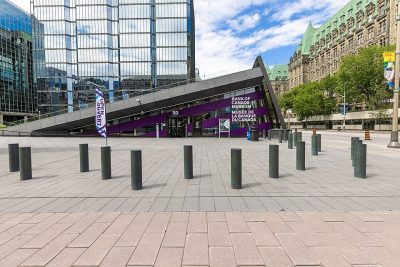 MuseumBank of Canada Museum4.5 km outside town, to the northwest
 ZooCanada Agriculture and Food Museum1.3 km outside town, to the northwest
 Art galleryNational Gallery of Canada7 km northwest · 237K visitors a year (2014)
 Big drawMuseumCanadian Museum of History7.2 km northwest · 1.3M visitors a year
 MuseumCanada Science and Technology Museum6.6 km northeast · 348K visitors a year
 Big drawMuseumCanadian Children's Museum7.1 km northwest · 500K visitors a year
 ChurchNotre-Dame Roman Catholic Basilica7 km north
 CastleRideau Hall and Landscaped Grounds8.6 km north
 MuseumCanada Aviation and Space Museum11 km north
 WaterfallRideau Falls8.3 km north
 CathedralSt Joseph Cathedral8.5 km northwestGardenGardenMajor's Hill Park6.7 km northwest
 MuseumHumanics Sanctuary and Sculpture Park30 km northeast
 GardenJacques Cartier Park8.1 km northwest
 7
 8
 9
 10
 11
 12
 13
 14
 16