Doon Heritage Village
History and living history museum in Ontario, Canada.
Each edition grades its towns against each other only.

Visitors to Pioneer Park can choose from 4 museums, 2 water parks and a ski hill. Look within 5 km of its edge for the 8 places to visit; none is inside Pioneer Park’s neighbourhood outline. Of these, one is looked after by Parks Canada. On foot, 2 are within 1 km of the centre. Make a day of it at Fashion History Museum, 12 km away.
 MuseumDoon Heritage Village100 m outside town, to the north · 80K visitors a year
 Ski hillChicopee Ski Club3.8 km outside town, to the north
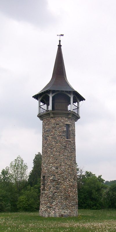 National historic site · Parks CanadaWaterloo Pioneer Memorial Tower600 m outside town, to the northeast
 MuseumHomer Watson House100 m outside town, to the eastMuseumMuseumKen Seiling Waterloo Region Museum100 m outside town, to the northWater parkWater parkRBJ Schlegel Splashpad3.2 km outside town, to the southwest
Each has a page of its own: what it is, who runs it, the weather month by month and what else is near it.
The map stretches to Splash Pad, 4.7 km away.
The dashed line is Pioneer Park’s neighbourhood outline; orange marks its middle (where most people live). Numbers match the list below. © OpenStreetMap contributors · Statistics Canada 2021 outline
Museums or galleries number 4, zoos, ski hills, theme parks or other days out 3.
Green: inside Pioneer Park. Grey: within 5 km of its edge.
Run by Parks Canada: Waterloo Pioneer Memorial Tower.
Close and well known first. Provincial and city parks are on the Outdoors page instead.
Historic places in Pioneer Park → · Parks, footpaths and green space in Pioneer Park →
 MuseumFashion History Museum12 km northeast
 MuseumTHEMUSEUM7.5 km northwest
 ZooAfrican Lion Safari23 km eastWaterfallWaterfallDarnley Cascade38 km eastWaterfallWaterfallBetzner Falls39 km eastWaterfallWaterfallWeir's Falls39 km eastWaterfallWaterfallMineral Springs Falls39 km eastWaterfallWaterfallGreensville Falls40 km eastWaterfallWaterfallProgreston Falls40 km east
 Abbey or prioryHoly Transfiguration Monastery (Milton, Ontario)40 km east
 MuseumJoseph Schneider Haus7.3 km northwest
 MuseumWoodside8.4 km northwest
Places well known beyond Pioneer Park (Wikipedia articles in several languages, published visitor counts, or a Parks Canada property), close and famous first. Distances are straight lines from the middle of the town.
None inside Pioneer Park; the closest, within 5 km, are Chicopee Ski Club, Homer Watson House and Ken Seiling Waterloo Region Museum.
Yes, Steckle Heritage Homestead, all in Pioneer Park or within 5 km.
Yes: places in or within 5 km of Pioneer Park are in the care of Parks Canada; the chart above names them.
Within 40 km: THEMUSEUM (7.5 km), African Lion Safari (23 km), Darnley Cascade (38 km), Betzner Falls (39 km).
Museums, galleries, national historic sites, forts, lighthouses, gardens, national parks, waterfalls, ski hills, zoos and theme parks from OpenStreetMap, Wikidata, ODCAF and the heritage registers are merged into one list. A historic building needs a sign it welcomes visitors (opening hours, a fee, a website, a heritage operator or a Wikipedia article); hotels, restaurants and tour operators are left out. Each place is put in the town’s 2021 outline or within 5 km of its edge.
Places to visit: Canada publishes no open tourism list, so this one is assembled from OpenStreetMap (© OpenStreetMap contributors, ODbL), Wikidata (CC0), Statistics Canada’s ODCAF museums and galleries (2020, Open Government Licence – Canada), the federal and Québec heritage registers and CPCAD’s national parks, and it reflects what mappers and editors have recorded. Forts, houses, lighthouses and churches count only with a sign that visitors are welcome. Places sit in each town’s 2021 census outline; visitor counts are Wikidata’s latest, with their year.
Photos: each place’s Wikidata image, from Wikimedia Commons under the licence below (our copy, resized).
Adapted from Statistics Canada (Census of Population 2021, population estimates 2025, 2021 census boundaries) under the Statistics Canada Open Licence; this does not constitute an endorsement by Statistics Canada. Neighbourhood names in some cities © OpenStreetMap contributors (ODbL).