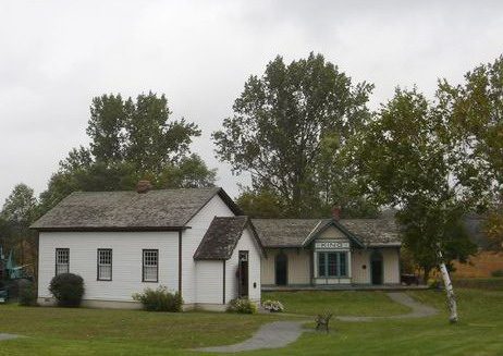
King Township Museum
King Township Museum is a municipal museum. It stands inside King’s municipal boundary. There are 11 more places to see within 15 km, beginning with Leviathan (8.9 km).
Museum in King
Inside King
King Township Museum sits inside King’s municipal boundary. Towns near it ↓
Drawn from OpenStreetMap, Wikidata, ODCAF and the heritage registers, with Statistics Canada’s 2021 outlines and ECCC’s 1991–2020 normals.
The climate through the year
Expect highs of 19–27°C in King from May to September.
King Township Museum
Readers can find it on Wikipedia in 3 languages.
- Type
- Museum
- Wikipedias
- Covered in 3 languages
- Town
- in King
Visit details
Mapping King Township Museum
Use the numbers to match each place near King Township Museum with the list.
© OpenStreetMap contributors · The dashed line is King’s municipal boundary. · Statistics Canada 2021 outline
Where to base yourself
With 29,077 people, King is the largest of the 8. From nearest to farthest, these towns all list it.
King
Hope
Purpleville
Peace Village
Compare the 8 towns
| Town | Where King Township Museum is | People | Places to visit |
|---|---|---|---|
| King | It’s in town | 29,077 | 5 |
| Hope | 1.7 km southeast of it | 6,997 | 55 |
| Purpleville | 2.2 km south of it | 19,918 | 56 |
| Peace Village | 4.6 km south of it | 14,598 | 55 |
| Teston | 6.5 km southeast of it | 7,437 | 52 |
| Upper Thornhill Estates | 8.5 km southeast of it | 10,435 | 16 |
| Maple | 8.8 km southeast of it | 20,122 | 53 |
| Carrville Corners | 9.5 km southeast of it | 13,004 | 56 |
More to see nearby
 AttractionLeviathan8.9 km away2AttractionAttractionRiptide9.1 km away3AttractionAttractionSpeed City Raceway9 km away4AttractionAttractionDrop Tower9.1 km away5AttractionAttractionSpinovator9.1 km away6AttractionAttractionSnoopy's Space Race9.1 km away7AttractionAttractionWilde Knight Mares9.1 km away8AttractionAttractionSwan Lake9.1 km away
Within 15 km, close and well known first. Numbers match the map.
King Township Museum, answered
Where is King Township Museum?
King Township Museum is in King, Ontario, inside the town’s municipal boundary.
What is King Township Museum?
Municipal museum in Ontario, Canada.
How well known is King Township Museum?
Wikipedia coverage puts King Township Museum at #577 among Canadian places.
When is the best time to visit King Township Museum?
For warmth, aim for May to September: highs of 19–27°C in King (ECCC 1991–2020 normals).
Sources: © OpenStreetMap contributors (ODbL), Wikidata (CC0), Statistics Canada’s ODCAF (Open Government Licence – Canada), the federal and Québec heritage registers, Statistics Canada 2021 census boundaries, ECCC 1991–2020 climate normals (Open Government Licence – Canada).
Photos: each place’s Wikidata image, from Wikimedia Commons under the licence below (our copy, resized).
Photo credits (2)
- King Township Museum: Andrea Kollo, uploading as Kingtourism at en.wikipedia, Public domain, Wikimedia Commons
- Leviathan: Chris!!!!!, CC BY 2.0, Wikimedia Commons
Adapted from Statistics Canada (Census of Population 2021, population estimates 2025, 2021 census boundaries) under the Statistics Canada Open Licence; this does not constitute an endorsement by Statistics Canada. Neighbourhood names in some cities © OpenStreetMap contributors (ODbL).