 Fed
Heritage Railway Station · 1938–1940Canadian National Railways Station, Casselman, Ontario66 St. JosephPhoto: bibliocom · CC BY-SA 3.0 · Commons file
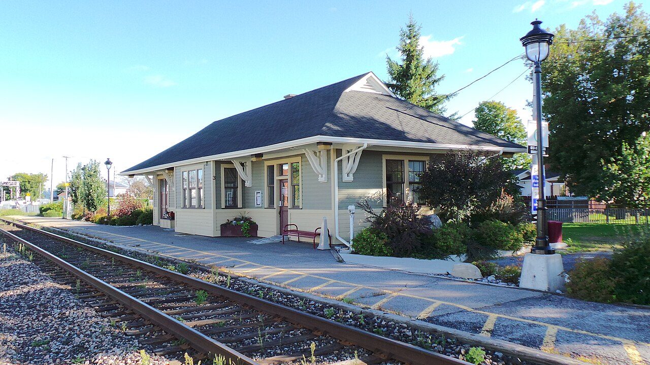 Canadian National Railways Station, Casselman, Ontario · Photo: bibliocom · CC BY-SA 3.0
1historic place on the registers
History of Casselman · Canada’s heritage registers
Casselman’s past, on the record: 1 historic place
Casselman’s entry is Canadian National Railways Station, Casselman, Ontario (1938), a heritage railway station. The municipality’s date on Wikidata is 1844: a founding, an incorporation or an amalgamation, the record doesn’t say which. Scaled to its population, Casselman’s 2.2 per 10,000 residents beats 87% of Canadian towns.
Historic places
1
2.2 per 10,000 residents
Highest designations
0
National Historic Sites and Classified Federal Heritage Buildings
Other federal designations
1
Recognized buildings, railway stations, lighthouses
Oldest building
1938
the first construction date on its record
Homes built before 1961
14%
typical town: 18%
The map
Where Casselman’s history is
Every place on the registers inside the town, by its designation.
Other federal designations
Hover a dot for its name; tap one to open its page.
The 1, by tier
1 Other federal designations
Parks Canada’s Directory of Federal Heritage Designations lists the places the Government of Canada has recognized; outside Québec, provincial and municipal listings come only through Wikidata, and only those with an encyclopedia article get a page.
Points from Wikidata (Parks Canada’s files carry none) and from Québec’s register, as mapped there.
Other federal designations
One other place Canada recognizes in Casselman
Recognized Federal Heritage Buildings, heritage railway stations and lighthouses. Each one opens its own page.
Around the town
The highest designation, 51 times, within 50 km of Casselman
117 places lie within 50 km. Nearest comes Croix de chemin à Plaisance, 33 km off, in Plaisance. They belong to 24 towns, chiefly Centretown, Lowertown West and Papineauville.
The 12 nearest, within 50 km
| Croix de chemin à PlaisanceMunicipal citation (Québec) · 33 km away, in Plaisance |
| Cimetière de PlaisanceCited heritage site (Québec) · 33 km away, in Plaisance |
| Church of the Purest Heart of Mary, PlaisanceMunicipal citation (Québec) · 1901 · 33 km away, in Plaisance |
| Presbytère du Coeur-Très-Pur-de-MarieMunicipal citation (Québec) · 1901 · 33 km away, in Plaisance |
| Croix de chemin de la côte Saint-FrançoisMunicipal citation (Québec) · 1940 · 33 km away, in Plaisance |
| Croix de chemin de la Côte-Saint-CharlesMunicipal citation (Québec) · 34 km away, in Papineauville |
| Site patrimonial du parc Henri-BourassaCited heritage site (Québec) · 35 km away, in Papineauville |
| Ancien presbytère de Sainte-AngéliqueMunicipal citation (Québec) · 1882 · 35 km away, in Papineauville |
| Church of St Angela, PapineauvilleMunicipal citation (Québec) · 1902–1903 · 35 km away, in Papineauville |
| Maison du bedeauMunicipal citation (Québec) · 1862 · 35 km away, in Papineauville |
| Couvent de PapineauvilleMunicipal citation (Québec) · 1907–1908 · 35 km away, in Papineauville |
| Plaque souvenir d'Henri BourassaMunicipal citation (Québec) · 35 km away, in Papineauville |
Homes by age
10% of Casselman’s homes are from 2016 to 2021 (4.1% is typical)
Only 14% of Casselman’s homes predate 1961, against 18% in the typical town. Casselman’s largest group of homes, 35%, went up from 1981 to 2000. Few of Casselman’s homes date from 1961 to 1980: 15%, the norm 27%.
14%
Before 1961
15%
1961–80
35%
1981–2000
26%
2001–15
10%
2016–21
CasselmanTypical town
2021 Census, private dwellings by period of construction (Statistics Canada); the typical town is the middle Canadian town of 2,500 or more.
Towns its size
Casselman has the 2nd most of 16 towns its size
Towns of 4,500 to 4,600 residents, by places on the registers.
Casselman1
Only Melville has more. The typical town its size has 0. 12 of them have nothing on the registers.
Neighbours
Casselman and its neighbours
| Town | People | Places | Highest | Oldest |
|---|---|---|---|---|
| Casselman | 4,535 | 1 | 0 | 1938 |
| Limoges | 15,122 | 0 | 0 | — |
| North Stormont | 7,946 | 0 | 0 | — |
| Embrun | 23,655 | 0 | 0 | — |
In brief
Casselman in brief
The registers count 1 historic place in Casselman. Of the 16 towns closest in size, just one has more historic places. Before 1961: just 14% of its homes, against 18% in the typical town. For the rest, its one place was designated in 1994.
How to read these numbers
What this data can and can’t tell you
- People and events. Parks Canada’s open file gives its national historic persons no place. A town’s page names one only when the person was born there (matched by name and both life years) or one of its own historic places carries the name and its record speaks of them; national historic events stay off.
- Provincial and municipal lists. Outside Québec, provinces’ and municipalities’ heritage registers aren’t open data; their places are known only through Wikidata items with a register number, and only those with an encyclopedia article get a page.
- Map points. Federal places get their map points from Wikidata, since Parks Canada’s files carry none; they are as mapped there.
- The federal register. Every federal designation is in Parks Canada’s directory, and the Canadian Register of Historic Places gives most of them a bilingual statement of significance.
- Protection. Federal recognition isn’t a planning control: buildings the federal government owns follow its heritage policy, while others are protected only by a provincial or municipal designation.
- The grade. This page gives no grade; history doesn’t count toward a Canadian town’s letter.
- The tiers. The highest designations are National Historic Sites, Classified Federal Heritage Buildings and Québec’s classements; then come the other federal designations; then provincial and local listings.
Questions about Casselman’s history
How many historic places does Casselman have on the registers?
The registers list 1 historic place inside Casselman.
What is the oldest building in Casselman?
Canadian National Railways Station, Casselman, Ontario (Heritage Railway Station): the first construction date on its record is 1938.
How old are the homes in Casselman?
Before 1961: 14% of its homes; the typical town has 18%.
Contains information licensed under the Open Government Licence – Canada (Parks Canada).
Sources: Parks Canada, Directory of Federal Heritage Designations · Canadian Register of Historic Places (federal extract) · Wikidata (CC0) for map points, other names and articles · Statistics Canada, 2021 Census (homes by period of construction). Under the Statistics Canada Open Licence.
Adapted from Statistics Canada (Census of Population 2021, population estimates 2025, 2021 census boundaries) under the Statistics Canada Open Licence; this does not constitute an endorsement by Statistics Canada. Neighbourhood names in some cities © OpenStreetMap contributors (ODbL).