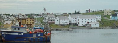
 Photo: United Kingdom Hydrographic Office · Public domain
Out and about near Trinity Bay North
One place to visit we list is in Trinity Bay North or within 5 km of its edge: Port Union Museum. Ryan Premises, 15 km away, is the best-known day out.
Starting nearby
Distances on the map
3 places are numbered, in the order below.
The middle of Trinity Bay North is the orange dot. © OpenStreetMap contributors · Statistics Canada 2021 outline
Sorted by kind
Green: inside Trinity Bay North. Grey: the rest, within 40 km.
In Trinity Bay North first, then nearby
In town there is one, and the list adds 2 more within 40 km.
What is in or close to Trinity Bay North comes first, then the best known within 40 km, close and well known first. Provincial and city parks are on the Outdoors page instead.
Historic places in Trinity Bay North → · Parks, footpaths and green space in Trinity Bay North →
Big names within reach
From 2 places within 40 km, these are the best known.
 2Museum · Parks CanadaRyan Premises15 km northwest
 3National historic site · Parks CanadaRyan Residence15 km northwest
The best known within 40 km, the closest and best known first.
The nearest town with more to see: Bonavista →
Know before you go to Trinity Bay North
Is there a Parks Canada property near Trinity Bay North?
None within 5 km; the nearest, run by Parks Canada, is the one named above, 15 km northwest.
What are the best-known days out near Trinity Bay North?
For a day out within 40 km: Ryan Residence (15 km).
How is this list made?
Places come from four open sources (OpenStreetMap, Wikidata, Statistics Canada’s ODCAF, the federal and Québec heritage registers), each site once. A building counts as a place to visit only with opening hours, a fee, a website, a heritage operator or a Wikipedia article; hotels, restaurants and tour firms are dropped. The town’s 2021 outline and 5 km around it set the reach.
Places to visit: Canada publishes no open tourism list, so this one is assembled from OpenStreetMap (© OpenStreetMap contributors, ODbL), Wikidata (CC0), Statistics Canada’s ODCAF museums and galleries (2020, Open Government Licence – Canada), the federal and Québec heritage registers and CPCAD’s national parks, and it reflects what mappers and editors have recorded. Forts, houses, lighthouses and churches count only with a sign that visitors are welcome. Places sit in each town’s 2021 census outline; visitor counts are Wikidata’s latest, with their year.
Photos: each place’s Wikidata image, from Wikimedia Commons under the licence below (our copy, resized).
Photo credits (2)
- Ryan Premises: Silverchemist, CC BY 3.0, Wikimedia Commons
- Ryan Residence: Lukester878, CC BY-SA 3.0, Wikimedia Commons
Adapted from Statistics Canada (Census of Population 2021, population estimates 2025, 2021 census boundaries) under the Statistics Canada Open Licence; this does not constitute an endorsement by Statistics Canada. Neighbourhood names in some cities © OpenStreetMap contributors (ODbL).