
Grants Old Mill tops the list of what to see in Wolseley
Of the 70 places to visit in and around Wolseley, 50 are museums or galleries. Mapped inside Wolseley’s neighbourhood outline are 2 places to visit, and within 5 km of its edge another 68. Manitoba Children's Museum draws about 135K visitors a year. Day-trippers head 11 km out to Prairie Dog Central Railway.
The names to know in Wolseley
 MuseumCanadian Museum for Human Rights2.2 km outside town, to the east
 Art galleryWinnipeg Art Gallery800 m outside town, to the northeastMuseumMuseumManitoba Children's Museum2.3 km outside town, to the east · 135K visitors a year
 CathedralSaint Boniface Cathedral2.8 km outside town, to the east
Each has a page of its own: what it is, who runs it, the weather month by month and what else is near it.
The map view
The list reaches out to Fort Garry Horse Museum & Archives, 5.7 km away.
The dashed line is Wolseley’s neighbourhood outline; orange marks its middle (where most people live). Numbers match the list below. © OpenStreetMap contributors · Statistics Canada 2021 outline
What there is to see
Green: inside Wolseley. Grey: within 5 km of its edge.
The complete list
Saint Boniface Cathedral
Church building in Manitoba, Canada.
 7
St. Mary's Cathedral, Winnipeg
Catholic cathedral in Winnipeg, Manitoba, Canada.
Manitoba Museum
Provincial human and natural history museum in Manitoba, Canada.
 9
Ukrainian Cultural and Educational Centre
Museum, gallery and library dedicated to Ukrainian culture in Vinnipeg, Manitoba, Canada.
 11
 12
 13
Cathedral of Sts. Vladimir and Olga
Ukrainian Catholic cathedral in Winnipeg, Manitoba, Canada.
 14
Grey Nuns' Convent
History museum in Winnipeg (Manitoba, Canada) housed in the former Grey Nuns Convent.
 15
 16
Royal Aviation Museum of Western Canada
Aviation museum in Winnipeg, Manitoba.
 17
 18
 19
Ross House Museum
Historic house museum in Manitoba, Canada.
 20

Cathedral of St. John
Church in Manitoba, Canada.

Manitoba Electrical Museum
Electrical museum in Winnipeg, Manitoba.

St. Vital Historical Society
Museum in Manitoba, Canada..
Manitoba Crafts Museum and Library
Handcrafts museum in Winnipeg, Manitoba, Canada.

Air Force Heritage Museum and Air Park
Air Force museum in St. James (Winnipeg), Manitoba.
The Queen's Own Cameron Highlanders of Canada Museum
Queen's Own Cameron Highlanders of Canada military museum in Manitoba, Canada..

Fort Garry Horse Museum & Archives
Regimental museum in Manitoba, Canada.


The 2 inside Wolseley come first, best known first; then the places within 5 km, close and well known first. Provincial and city parks are on the Outdoors page instead.
Historic places in Wolseley → · Parks, footpaths and green space in Wolseley →
Trips out
 Museum · Parks CanadaRiel House7.3 km south
 MuseumMarine Museum of Manitoba37 km northeast
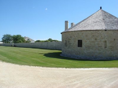 Museum · Parks CanadaLower Fort Garry31 km northeast
 MuseumSt. Andrew's Rectory25 km northeast
Places well known beyond Wolseley (Wikipedia articles in several languages, published visitor counts, or a Parks Canada property), close and famous first. Distances are straight lines from the middle of the town.
What people ask about Wolseley
What are the main attractions in Wolseley?
The place to visit inside Wolseley’s neighbourhood outline is St. James-Assiniboia Museum.
Does Wolseley have a museum?
Look at Winnipeg Art Gallery, Manitoba Museum and Ukrainian Cultural and Educational Centre, in Wolseley or within 5 km.
Is there a Parks Canada property near Wolseley?
None within 5 km. The nearest well-known one on our list is Riel House (Parks Canada), 7.3 km south.
What are the best-known days out near Wolseley?
For a day out within 40 km: Marine Museum of Manitoba (37 km), Lower Fort Garry (31 km), St. Andrew's Rectory (25 km).
How is this list made?
Museums, galleries, national historic sites, forts, lighthouses, gardens, national parks, waterfalls, ski hills, zoos and theme parks from OpenStreetMap, Wikidata, ODCAF and the heritage registers are merged into one list. A historic building needs a sign it welcomes visitors (opening hours, a fee, a website, a heritage operator or a Wikipedia article); hotels, restaurants and tour operators are left out. Each place is put in the town’s 2021 outline or within 5 km of its edge.
Places to visit: Canada publishes no open tourism list, so this one is assembled from OpenStreetMap (© OpenStreetMap contributors, ODbL), Wikidata (CC0), Statistics Canada’s ODCAF museums and galleries (2020, Open Government Licence – Canada), the federal and Québec heritage registers and CPCAD’s national parks, and it reflects what mappers and editors have recorded. Forts, houses, lighthouses and churches count only with a sign that visitors are welcome. Places sit in each town’s 2021 census outline; visitor counts are Wikidata’s latest, with their year.
Photos: each place’s Wikidata image, from Wikimedia Commons under the licence below (our copy, resized).
Photo credits (26)
- Canadian Museum for Human Rights: Ethan Sahagun, CC BY 4.0, Wikimedia Commons
- Winnipeg Art Gallery: Cayla at English Wikipedia, Public domain, Wikimedia Commons
- Saint Boniface Cathedral: Dondon83~commonswiki, Public domain, Wikimedia Commons
- St. Mary's Cathedral, Winnipeg: NellieBly, CC BY-SA 3.0, Wikimedia Commons
- Ukrainian Cultural and Educational Centre: Ccyyrree, CC0, Wikimedia Commons
- Winnipeg Railway Museum: Milorad Dimic MD, Nis, Serbia, CC BY-SA 4.0, Wikimedia Commons
- Dalnavert: Jessica Losorata, CC BY-SA 4.0, Wikimedia Commons
- Cathedral of Sts. Vladimir and Olga: Amakuha, CC BY 4.0, Wikimedia Commons
- Grey Nuns' Convent: Colincan, CC BY-SA 3.0, Wikimedia Commons
- Fort Gibraltar: Peter Rindisbacher, Public domain, Wikimedia Commons
- Royal Aviation Museum of Western Canada: Bzuk at English Wikipedia, Public domain, Wikimedia Commons
- Holy Trinity Ukrainian Orthodox Metropolitan Cathedral: noricum from Canada, CC BY-SA 2.0, Wikimedia Commons
- Pavilion Gallery Museum: JacobTwo, Public domain, Wikimedia Commons
- Ross House Museum: 1ajs, CC BY 3.0, Wikimedia Commons
- Assiniboine Park Zoo: Jimj wpg, CC BY-SA 4.0, Wikimedia Commons
- Cathedral of St. John: Misterpartel, Public domain, Wikimedia Commons
- Manitoba Electrical Museum: Wtshymanski, Public domain, Wikimedia Commons
- St. Vital Historical Society: w:en:NellieBly, CC BY 3.0, Wikimedia Commons
- Air Force Heritage Museum and Air Park: Wtshymanski, CC BY-SA 4.0, Wikimedia Commons
- Centre du patrimoine: Amélie Drainville, CC BY-SA 4.0, Wikimedia Commons
- Maison Gabrielle-Roy: Colincan, CC BY-SA 3.0, Wikimedia Commons
- Union Station / Winnipeg Railway Station (Canadian National): Quintin Soloviev, CC BY 4.0, Wikimedia Commons
- Riel House: Hans-Jürgen Hübner, CC BY 3.0, Wikimedia Commons
- Marine Museum of Manitoba: photo by Brian Westhouse, uploaded in en.wikipedia by Wrecksdale Wreck, CC BY-SA 3.0, Wikimedia Commons
- Lower Fort Garry: Vintotal, Public domain, Wikimedia Commons
- St. Andrew's Rectory: Shahnoor Habib Munmun, CC BY 3.0, Wikimedia Commons
Adapted from Statistics Canada (Census of Population 2021, population estimates 2025, 2021 census boundaries) under the Statistics Canada Open Licence; this does not constitute an endorsement by Statistics Canada. Neighbourhood names in some cities © OpenStreetMap contributors (ODbL).