 1
White Rock Pier
Pier in White Rock, British Columbia, Canada.
Each edition grades its towns against each other only.

This is a list led by museums or galleries, 3 of its 5. All of them lie outside South Surrey. Stanley Park is worth a day, 36 km from the centre.
PierWhite Rock Pier1.6 km outside town, to the southEach has a page of its own: what it is, who runs it, the weather month by month and what else is near it.
Darts Hill Garden Park, 5.1 km away, is the farthest on the map.
The dashed line is South Surrey’s neighbourhood outline; orange marks its middle (where most people live). Numbers match the list below. © OpenStreetMap contributors · Statistics Canada 2021 outline
Green: inside South Surrey. Grey: within 5 km of its edge.
1Pier in White Rock, British Columbia, Canada.
Public garden in Surrey, British Columbia, Canada.
Museum in White rock, British Columbia.
Close and well known first. Provincial and city parks are on the Outdoors page instead.
Historic places in South Surrey → · Parks, footpaths and green space in South Surrey →
 GardenStanley Park36 km northArt galleryArt galleryVancouver Art Gallery34 km north
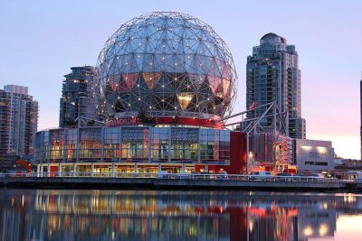 Big drawMuseumScience World32 km north · 650K visitors a year
 MuseumMuseum of Vancouver34 km north · 78K visitors a year
 GardenQueen Elizabeth Park30 km north
 CathedralCathedral of Our Lady of the Rosary, Vancouver33 km northMuseumMuseumCanadian Museum of Flight14 km eastMuseumMuseumVancouver Maritime Museum35 km north
 AquariumVancouver Aquarium36 km north
 GardenVanDusen Botanical Garden31 km northCathedralCathedralChrist Church Cathedral34 km north
 GardenDr. Sun Yat-Sen Classical Chinese Garden33 km north
Places well known beyond South Surrey (Wikipedia articles in several languages, published visitor counts, or a Parks Canada property), close and famous first. Distances are straight lines from the middle of the town.
Not within 5 km of South Surrey: none is on our list.
Further out, up to 40 km: Vancouver Art Gallery (34 km), Science World (32 km), Museum of Vancouver (34 km), Queen Elizabeth Park (30 km).
Historic buildings need a visitor sign such as opening hours, a fee, a website, a heritage operator or a Wikipedia article, and hotels, restaurants and tour operators never count. A place belongs to the town when it lies inside its 2021 outline or within 5 km of the edge.
Places to visit: Canada publishes no open tourism list, so this one is assembled from OpenStreetMap (© OpenStreetMap contributors, ODbL), Wikidata (CC0), Statistics Canada’s ODCAF museums and galleries (2020, Open Government Licence – Canada), the federal and Québec heritage registers and CPCAD’s national parks, and it reflects what mappers and editors have recorded. Forts, houses, lighthouses and churches count only with a sign that visitors are welcome. Places sit in each town’s 2021 census outline; visitor counts are Wikidata’s latest, with their year.
Photos: each place’s Wikidata image, from Wikimedia Commons under the licence below (our copy, resized).
Adapted from Statistics Canada (Census of Population 2021, population estimates 2025, 2021 census boundaries) under the Statistics Canada Open Licence; this does not constitute an endorsement by Statistics Canada. Neighbourhood names in some cities © OpenStreetMap contributors (ODbL).