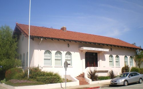
Founding year: the first Whittier post office (Blevins & Helbock, CC0).The full story ↓
History grade
What drives Whittier’s History grade
On its age, its old homes and the National Register, Whittier is more historic than 60% of U.S. towns, #103 of 847 in California. Its National Register listings hold the grade up; its age pulls it down.
B
HistoryA character grade: shown, never part of Whittier’s overall grade.
Few California towns list much on the Register (a typical California town has 0.0 per 10,000 residents, the U.S. 2.4), so Whittier’s 0.7 sits above most of its state (73% of California towns have fewer) while its 6 listings outnumber those of 72% of U.S. towns.
How sure. Graded on any two of the three inputs instead, the letter would range from C+ to B+. The pre-1940 share (±1.4 points) is firm at this size. The founding year is the first post office, not a stated founding date.
Founding year: the first post office (other dates in Quick answers). Homes: Census ACS 2020–24. National Register: National Park Service, May 2026 list; each listing counted once (boundary changes and added documentation belong to their listing), and a historic district counts its contributing buildings. How TownRatings grades history →
What stands out about Whittier’s past
Read from the archive, the National Register and the record. The page puts what stands out first.
Fire insurance maps drew every building, what it was made of and what it was used for, so insurers could price the risk of fire. Pick a year, then a sheet.
1888Sheet 1 of 1
Edition
Sheets
BrickWoodStone
Sanborn Map Company, via the Library of Congress. Editions published in 1930 or earlier, which are in the public domain.
Whittier's roots can be traced to Spanish soldier Manuel Nieto. In 1784, Nieto received a Spanish land grant of 300,000 acres (1,200 km2), Rancho Los Nietos, as a reward for his military service and to encourage settlement in California. The area of Nieto's land grant was reduced in 1790 as the result of a dispute with Mission San Gabriel. Nonetheless, Nieto still had a claim to 167,000 acres (680 km2) stretching from the hills north of Whittier, Fullerton, and Brea, south to the Pacific Ocean, and from what is known today as the Los Angeles River east to the Santa Ana River. Nieto built a rancho for his family near Whittier, purchased cattle and horses for his ranch, and planted cornfields. When he died in 1804, his children inherited his property.
Passages that mention Whittier, cut from the printed page as they were published.
An illustrated history of Los Angeles County, California. Containing a history of Los Angeles County from the earliest period of its occupancy to the present time, together with glimpses of its prospective future ... and biographical mention of many of it1889 · page 822Read the page →
Read the text
In 1873 he returned to Los Angeles County, and had his herds in various locations until 1877. In that year he rented the Town Ranch and other lands where the town of Whittier now stands. From nearly his first occupation of those lands he commenced their purchase.
Text read by machine from the scan; it may contain errors.
Scans and text from the Internet Archive. Books published in 1930 or earlier, which are in the public domain.
Timeline
Whittier, 1860 to 1994
Woven from the archive, old maps, post office records, the National Register and the people born here.
Nothing in the archives for these yearsWeddings on Main Street, storms, parades, school pictures, the old store. If it’s in your family album, it belongs here.
John Muir High SchoolschoolJonathan Bailey SchoolschoolLeffingwell RanchlocaleMexican Friends ChurchchurchMurphy Memorial HospitalhospitalMurphy RanchlocaleWhittier Avenue Public SchoolschoolWhittwood Mall Shopping CenterlocaleWilliam Penn Schoolschool
1cemetery inside Whittier
Mount Olive
US Post Offices dataset (Blevins & Helbock, CC0). Places and cemeteries from the USGS Geographic Names Information System (2021).
Stories next door
History across the town line
Each neighbor’s History grade, on the same three inputs.
The Whittier post office opened in 1887, the earliest record of the town by name (U.S. post office records).
How does Whittier rank for history?
Whittier is more historic than 60% of U.S. towns, #103 of 847 in California. The History grade combines the town’s founding era, the share of homes built before 1940 and its National Register listings. It’s a character grade, so it isn’t part of the overall grade. How it works.
What is on the National Register in Whittier?
6 listings: 6 buildings, among them the Jonathan Bailey House (listed 1977, the first).
How old are the homes in Whittier?
14% of Whittier’s homes were built before 1940 (Census estimate, ±1.4 points), against a typical 3.4% for a California town; the median home was built in 1956.
Founding dates: Wikidata, Wikipedia, the U.S. post office records of Blevins & Helbock (CC0) and the Census. Homes by year built: Census ACS 2020–24. National Register of Historic Places: National Park Service (list of May 22, 2026). Old photos, postcards and papers: Wikimedia Commons, the Library of Congress and other public archives, credited on each item’s page. Maps: U.S. Geological Survey historical topographic maps (via Esri) and Sanborn fire-insurance maps (Library of Congress). History text and census tables: Wikipedia (CC BY-SA 4.0). Places that used to be: USGS Geographic Names Information System (2021).
From Wikimedia Commons (20), the Library of Congress (1), Wikidata (3), the National Register of Historic Places (6), Wikipedia, Wikidata and Wikipedia for famous people, U.S. Geological Survey historical maps, U.S. Census counts (via Wikipedia), the US Post Offices dataset (Blevins & Helbock), the USGS Geographic Names Information System, Sanborn fire insurance maps (Library of Congress) and old county and town histories (Internet Archive). Archive images are copied here with their credits and licenses, shown on each photo’s page. Refreshed monthly.





 Date?
 Date?
 Date?
 Date?
 Date?
 Date?
 Date?
 Date?
 Date?
 Date?
 Date?
 Date?
 Date?
 Date?
 Date?
 Date?
 2026
 2026
 2026
 2026


