Founding year: Wikidata. First post office: 1851.The full story ↓
History grade
What drives Sonora’s History grade
On its age, its old homes and the National Register, Sonora is more historic than 68% of U.S. towns, #60 of 847 in California. Its National Register listings hold the grade up; its age pulls it down.
B+
HistoryA character grade: shown, never part of Sonora’s overall grade.
Few California towns list much on the Register (a typical California town has 0.0 per 10,000 residents, the U.S. 2.4), so Sonora’s 18.3 sits above most of its state (95% of California towns have fewer) while its 9 historic buildings outnumber those of 75% of U.S. towns.
How sure. Graded on any two of the three inputs instead, the letter would range from C+ to A−. The pre-1940 share is a Census survey estimate (±5.2 points). Two sources give 1850.
Founding year: Wikidata (other dates in Quick answers). Homes: Census ACS 2020–24. National Register: National Park Service, May 2026 list; each listing counted once (boundary changes and added documentation belong to their listing), and a historic district counts its contributing buildings. How TownRatings grades history →
What stands out about Sonora’s past
Read from the archive, the National Register and the record. The page puts what stands out first.
Lost a third of its people between 1860 and 1870, then grew 3-fold.
17 censuses, 1860–2020.
U.S. Census Bureau decennial counts, from the census table on Sonora’s Wikipedia page.
Every building
Sonora, building by building, 1890–1908
Fire insurance maps drew every building, what it was made of and what it was used for, so insurers could price the risk of fire. Pick a year, then a sheet.
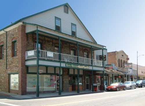
Sonora was founded by Mexican miners during the California gold rush. Sonorans were alongside Chileans among the most experienced miners in the rush. Named after their home state of Sonora, Mexico, it was once a booming center of industry and trade in California's Mother Lode. Most of the gold removable with traditional mining techniques was quickly extracted, leaving miners to use more complex and expensive mining techniques to reach deep pockets of quartz and gold. Sonora as well as other mining towns of the era experienced economic hardship when the value of gold decreased. As "gold fever" died down, Sonora's size and population steadily decreased over the years. In c. 1851, the Sonora Hebrew Cemetery was formed by the Hebrew Benevolent Society and predominantly contains the graves of European-born Jews who emigrated to Gold Country.
Passages that mention Sonora, cut from the printed page as they were published.
Kino's historical memoir of Pimería Alta1919 · page 67Read the page →
Read the text
The editor of Venegas calls it "the Manuscript History of the Missions of Sonora," Alegre "the relation of Sonora," and Ortega a relation, or papers, "in which his expeditions, undertakings, and discoveries are coordinated." No such work has been known to modern scholars, I believe, and, so far as I have been able to discover with the resources at my command, the references by Venegas, Ortega, and Alegre are the only ones
Text read by machine from the scan; it may contain errors.
Kino's historical memoir of Pimería Alta1919 · page 193Read the page →
Read the text
253 According to Manje the missionaries asked General Jironza, commander of the Compania Volante of Sonora, and Captain Ruiz de Avechuco, alcalde mayor of Sonora, for the services of Manje. Manje left the Real de San Juan Bautista, "capital" of the province, on January 6, 1699, with title of teniente de alcalde mayor y capitan a guerra. Traveling the forty leagues intervening, he arrived at Dolores on January 9. The departure thence was delayed by rains (Luz de Tierra Incognita, libro ii, 67).
Text read by machine from the scan; it may contain errors.
Scans and text from the Internet Archive. Books published in 1930 or earlier, which are in the public domain.
Timeline
Sonora, 1850 to 2020
Woven from the archive, old maps, post office records, the National Register and the people born here.
Nothing in the archives for these yearsWeddings on Main Street, storms, parades, school pictures, the old store. If it’s in your family album, it belongs here.
Nothing in the archives for these yearsWeddings on Main Street, storms, parades, school pictures, the old store. If it’s in your family album, it belongs here.
In 1850, according to Wikidata. Sonora’s post office opened in 1851, and the census of 1860 counted 1,960 people here.
How does Sonora rank for history?
Sonora is more historic than 68% of U.S. towns, #60 of 847 in California. The History grade combines the town’s founding era, the share of homes built before 1940 and its National Register listings. It’s a character grade, so it isn’t part of the overall grade. How it works.
What is on the National Register in Sonora?
6 listings: 6 buildings, among them the Tuolumne County Jail (listed 1978, the first). 9 historic buildings in all.
How old are the homes in Sonora?
16% of Sonora’s homes were built before 1940 (Census estimate, ±5.2 points), against a typical 3.4% for a California town; the median home was built in 1969.
Founding dates: Wikidata, Wikipedia, the U.S. post office records of Blevins & Helbock (CC0) and the Census. Homes by year built: Census ACS 2020–24. National Register of Historic Places: National Park Service (list of May 22, 2026). Old photos, postcards and papers: Wikimedia Commons, the Library of Congress and other public archives, credited on each item’s page. Maps: U.S. Geological Survey historical topographic maps (via Esri) and Sanborn fire-insurance maps (Library of Congress). History text and census tables: Wikipedia (CC BY-SA 4.0). Places that used to be: USGS Geographic Names Information System (2021).
From Wikimedia Commons (2), the Library of Congress (4), the National Register of Historic Places (6), Wikipedia, Wikidata and Wikipedia for famous people, U.S. Geological Survey historical maps, U.S. Census counts (via Wikipedia), the US Post Offices dataset (Blevins & Helbock), the USGS Geographic Names Information System, Sanborn fire insurance maps (Library of Congress) and old county and town histories (Internet Archive). Archive images are copied here with their credits and licenses, shown on each photo’s page. Refreshed monthly.




 1853
 1853


