Guest, Sign inJoin

Post to Oroville

We’ll email a one-tap link to publish your post. No password, and nothing is public until you click it.
Already a member? Sign in
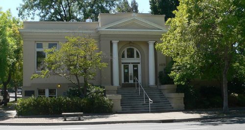
Oroville Inn (2024)-L1004244
California›Butte County

OrovilleCA

A town of 20,451, settled in 1854.

Trash & recycling
4 bordering townsMap →
Photo: Frank Schulenburg · CC BY-SA 4.0
Photo of Oroville

Oroville, CA · Photo: Frank Schulenburg · CC BY-SA 4.0 · Source ↗

Is Oroville a good place to live?

Oroville earns a D−, ranked 835th of 841 in California, mostly because of safety and incomes. Its crime rate is higher than 98% of U.S. towns, with 173 violent crimes reported to the FBI in 2025. The median household income is $52K, and 21% of residents live below the poverty line. In its favor, it has 10 miles of trail. Oroville’s violent crime rate is 8.8 per 1,000 residents, where California’s towns sit at 2.9 and U.S. towns at 1.6. On history, just 70 of California’s 1,063 towns do better. Riverbend Park, at 116 acres with 2.5 miles of trail, is the biggest park or preserve.

What makes Oroville stand out

Where Oroville beats most towns, and one thing worth knowing.

Oroville Chinese Temple
Oroville Chinese Temple · National Register of Historic Places
Oroville’s story

172 years in pictures

Census counts: 2,429 in 1860, a low of 1,425 in 1870, 20,042 in 2020. The archive holds 22 old photos and papers going back to 1863 and 3 maps from 1912 on.

5 places on the National Register of Historic Places.

  • 1854Oroville is settled
Explore the history →

How Oroville grades

Each subject compared with towns across the country (schools within California), ordered by how far Oroville is from typical.

How grading works

Character Graded, but not part of the overall grade.
Described, not graded Taste, not quality: snow or an older crowd is neither good nor bad.

How TownRatings grades towns →

Getting set up

Moving to Oroville: who provides what

Who provides power, water and the rest in Oroville, and how to reach them.

The full setup list →
PowerPG&E37.5¢/kWh · EIA 2025HIFLD · EIA
WaterCal-Water Service Co.-OrovilleNo health-based violations in 5 years · EPAEPA
Internet6 providers100% of addresses get 100/20 MbpsFCC
Trash & dumpRecology Transfer FacilityTown’s haulerTown site
SchoolsOroville Union High School DistrictOroville City Elementary School DistrictThermalito Union School District3 districts serve Oroville; which school depends on your address and gradeNCES
Register to voteOnlineIn California you can register online until 15 days before Election Day, in person up to and including Election Day, or by mail (postmarked 15 days before).vote.gov
Who runs elections hereButte County ElectionsButte County; contacts on the Handbook page.FVAP, Aug 2025
ZIP codes95966, 9596595966 54% · 95965 46%Census 2020

EPA SDWIS (Oct 9, 2026) · HIFLD + EIA-861 2025 · Census 2020 ZCTAs · NCES 2024–25 · registration: vote.gov, updated Nov 18, 2024.

The data

Ordered by what stands out in Oroville.

Oroville draws workers from Chico and beyond and is healthier than towns with similar incomes, but it reports violent crime at about twice the California rate.

SafetyD−

Oroville stands out in California and nationally, with property crime higher than most

Violent crime runs at 8.8 per 1,000 residents, about twice the California rate; the Safety Grade counts each violent crime four times, so this weighs most on its D−. Reported crimes fell from 1,180 to 859 over the last three FBI years, a drop beyond ordinary year-to-year swings.

The property crime rate in Oroville is 34.9 per 1,000 residents. Oroville reports more crime per resident than most U.S. towns we grade: about 98% report less.

2%of U.S. towns report more crimeD−Safety Grade

Violent crime per 1,000 residents

Oroville8.8
California4.4
U.S.3.3

Property crime per 1,000 residents

Oroville34.9
California18.2
U.S.15.5
2nd
percentile among U.S. towns we grade
2nd
percentile among CA towns
173
violent crimes reported in 2025
686
property crimes reported in 2025

FBI crime data, 2025 · crimes reported to police

SchoolsC−

On state tests, Oroville’s schools trail 81% of California districts

Two of its 18 schools are below, each with why it’s listed.

19%of CA districts it outscoresC−School Grade
SchoolLevelStudentsLetter
STREAM CharterLargest public elementary schoolGrades K–8Grades K–8515B+
Oroville HighLargest public high schoolGrades 9–12Grades 9–12872B−

NCES · EDFacts · graded within CA on state tests and graduation

HousingCost of living grade C−

Homes in Oroville are worth about $302K, by Zillow’s estimate

The typical value, about $302K, is 10% below its July 2022 peak. At about $302K, home values are down 3% in five years, against a rise of 13% across California.

The typical Oroville home is worth about $302,000, down 1.3% in a year, 60% below the California typical home. Oroville’s median rent is $1,093 a month.

$302KZillow home value
OrovilleCalifornia townsU.S. towns
Households that own their home53%64%73%
Median rent$1,093 a month$1,898 a month$1,185 a month

Typical home value

Oroville$302K
California$762K
Market temperature
Buyer’s marketA balanced marketBuyer’sSeller’s
43
days on market
98.1%
sale-to-list price
−1.3%
value change, 1 year
12
homes sold in May

Census ACS, 2020–24 · Zillow Home Value Index · Redfin Data Center

Work & commuteJobs & income grade D

About one in three working residents works right in Oroville

11,067 jobs are based in Oroville, 1.8 for every working resident, so most of the people who work here commute in. The average commute takes 19.9 minutes, against 28.7 across California.

About one in 3 of Oroville’s working residents works in town. Since 2013, Oroville has added 1,009 jobs, to 11,067 in 2023. 7.5% of workers work from home in Oroville.

32%work in town
OrovilleCalifornia townsU.S. towns
Working residents who work in town32%6.6%8%
Average trip to work20 minutes28 minutes25 minutes
Median household income$52,000$95,000$80,000
Work from home7.5%14%11%

Where working residents work

In Oroville32%
Chico13%
Oroville East7%
Sacramento3%
Yuba City2%
19 mi
median commute distance
11,067
jobs based in Oroville
A job hub
jobs vs. working residents
B+
Walkability grade: more walkable than 68% of U.S. towns

Census LEHD 2023 · ACS

HealthC−

Compared with most of California and the rest of the country, more of Oroville’s adults have been diagnosed with depression

Against the 6,552 U.S. towns with household incomes like Oroville’s, it is less healthy than 57%, so its C− isn’t only a matter of income.

27% of Oroville adults have been diagnosed with depression. Oroville beats the California average on 0 of 32 CDC measures and trails it on 20. 13% of Oroville adults have diabetes.

20%healthier than U.S. townsC−Health Grade
OrovilleCalifornia townsU.S. towns
Frequent mental distress (CDC PLACES)22%17%17%
Smoke cigarettes (CDC PLACES)19%11%14%
Fair or poor health (CDC PLACES)28%22%19%
Frequent physical distress (CDC PLACES)17%14%14%
32 measures vs. California
0 better12 too close to call20 worse
What stands outOrovilleCA
More older adults who have lost all their teeth19.6%10.6%
More adults with COPD9.2%5.1%
More smokers18.7%10.9%
Oroville Hospital
1.2 mi away · emergency room
2 of 3
care shortages: primary care, mental health
14th
percentile among CA towns

CDC PLACES 2025 · modeled estimates for adults · CMS · HRSA

OutdoorsA−

3.8% of Oroville is conserved land

10 miles of trail in 13 parks and preserves.

#456for trails in CA
3.8%
conserved · 334 of 8,855 acres
10 mi
of trails · 0.7 per sq mi
Biggest places to walkTrailsAcres
1. Riverbend Park2.5 mi116
2. Hewitt Park0.3 mi8
3. Nelson Park0.2 mi26

Trails & parks © OpenStreetMap contributors · Conserved land: USGS PAD-US

Climate

Four seasons and hot summers in Oroville

July afternoons average 96.3°, hotter than in 98% of U.S. towns; January nights average 39.2°.

Oroville has mild winters and hot summers.

96°summer high
OrovilleCalifornia townsU.S. towns
July high96°F89°F85°F
January low39°F41°F22°F

Typical low → high °F

Winter40–58°
Spring48–74°
Summer61–94°
Fall51–78°
Dec 13
typical first frost
Jan 30
typical last frost
+1.2°
vs. the 20th-century average
96°
typical summer high

NOAA U.S. Climate Normals, 1991–2020

Natural hazardsHazard risk grade C−

Inland flooding leads a high hazard risk in Oroville

Expected storm and flood damage is higher than in 65% of U.S. communities. Since 1986, 16 flood insurance claims have been paid out in Oroville.

65risk score of 100
FEMA risk score
65High riskLowerHigher
Inland floodingEarthquakesWildfire
16
paid flood claims since 1986
5
federal disasters paid out here

FEMA flood insurance claims · FEMA National Risk Index · OpenFEMA

Keep exploring

Everything we know about Oroville

20pages on Oroville
After high school

Colleges nearby

1 within 15 miles of the center of Oroville

About 4 of every 100 Oroville residents are enrolled in college, against 8 across California.

Prices by family income, graduation and earnings →

A growing town

Oroville has grown 31% since 2010

15,546 counted in 2010 and 20,042 in 2020; an estimated 20,451 in 2025.

15,5462010
20,0422020
20,4512025 est.

U.S. Census 2010 & 2020 counts · Census Bureau estimate, July 1, 2025

Landmarks

5 places in Oroville on the National Register of Historic Places.

All landmarks →

Famous people from Oroville

15 notable people were born in Oroville.

See all 15 →

About Oroville

City in California, United States

Official town website ↗

Oroville (Oro, Spanish for "Gold" and Ville, French for "town") is a city in and the county seat of Butte County of the U.S. state of California. As of the 2020 census, Oroville had a population of 20,042. After the 2018 Camp Fire that destroyed much of the town of Paradise, Oroville's population increased as many people who lost their homes moved there. Oroville is considered the gateway to Lake Oroville and Feather River recreational areas. The Berry Creek Rancheria of Maidu Indians of California is headquartered in Oroville. Oroville is adjacent to State Route 70 and in close proximity to State Route 99, which connects Butte County with Interstate 5. The city of Chico is about 23 miles (…

From Wikipedia, licensed CC BY-SA 4.0 · facts via Wikidata (CC0)

Area
14 sq mi
Elevation
167 ft
ZIP code
95965, 95966
Area code
530

Oroville’s neighbors

4 towns share a border with Oroville.

Explore the map →
How the neighbors grade
TownCA rankOverallCostSafetySchoolsHealth
Oroville#835D−C−D−C−C−
Oroville East#745D−C−—C−B−
Thermalito#812D−C+—CC−
South Oroville#809D−C−—C−C+
Palermo#840D−C−—C−D

Oroville East, Thermalito, South Oroville and Palermo report no FBI crime data of their own. Compare Oroville with a neighbor →

Questions about Oroville

Short answers, built from the data on this page.

Is Oroville, CA a good place to live?

Oroville grades D− overall, in the bottom 2% of U.S. towns and #835 of 841 in California. It grades C− for health, D− for safety and C− for schools. Safety is its weak spot, with a D−.

Is Oroville, CA expensive?

Yes. That is 4.5 years of the area's median household income ($67,928 across the Chico, CA metro area). Cost of living, which also weighs rents, property taxes and how many households pay 30% or more of their income for housing, grades C−.

What is Oroville, CA known for?

15 notable people were born here, including Doug LaMalfa and Jack Yerman.