The story
Read it all →How Fulton came to be
From Wikipedia’s history of Fulton.
The community is named after Thomas and James Fulton, who founded the community.
Text from Wikipedia, licensed CC BY-SA 4.0.
Each edition grades its towns against each other only.
Below: 2 old photos and papers, maps from 1942 on, and old-book passages.
The Fulton post office opened in 1871, the earliest record of the town by name.
Read from the archive, the National Register and the record. The page puts what stands out first.
The first neighbors to add old photos shape how Fulton’s history is told.
From Wikipedia’s history of Fulton.
The community is named after Thomas and James Fulton, who founded the community.
Text from Wikipedia, licensed CC BY-SA 4.0.
Passages that mention Fulton, cut from the printed page as they were published.

Russian River school disti'ict. This tine farm is located on the Guerneville branch of the North Pacific Railroad, near Meacham Station, about two miles west of the town of Fulton. Since taking up his residence here in 1880, Mr. Woolsey has devoted his attention to the breeding of thoroughbred sheep, fruit cultivation, and general farming. He has made many improve-
Text read by machine from the scan; it may contain errors.
iirst known as Fulton's Cross-Roads. Upon the completion of the North Pacific Railroad through this place, a town site was laid out and named Fulton. A postoifice was also established, and from that time the town has grown and prospered. Mr. Fulton has done much to produce this result. His liberality and enterprise have been felt in all public movements
Text read by machine from the scan; it may contain errors.
panionship and encouragement from such of his countrymen as were living in the vicinity. After looking about for a suitable tract of land he finally selected the ranch which is his home today, a very desirable tract of eighty acres within easy access to the tovvn of Fulton, which is his postoffice and market town. Knowledge of and familiarity with grape culture acquired in his native land have here been put to good account, for fifty acres of his land are tinder cultivation to the vine, and one hundred tons is an average year's yield. He finds a ready market for his fruit at the winery, for which he receives the uniform
Text read by machine from the scan; it may contain errors.Scans and text from the Internet Archive. Books published in 1930 or earlier, which are in the public domain.
Woven from the archive, old maps, post office records, the National Register and the people born here.
2 decades in the archive, from the 1880s to the 1900s. Scroll each row; tap a photo for its story.
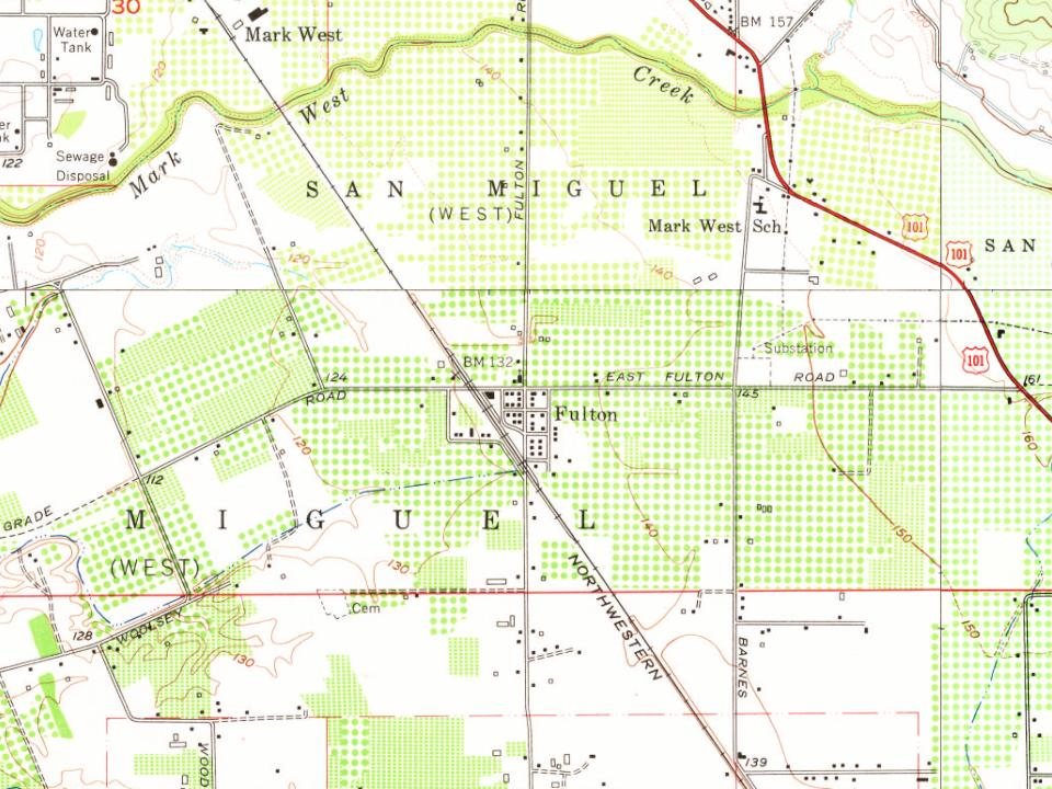
Every edition of the U.S. Geological Survey’s map of Fulton. Tap a year, or press play to watch the town change.

U.S. Geological Survey historical topographic maps (public domain), via Esri’s collection of the scans. The red ring marks the center of Fulton.
No then-and-now pairs yet. Take a photo from the same spot as an old one and they appear here side by side.

Find the spot, match the angle, and add your photo. It becomes the first then-and-now pair on Fulton’s page.
Retake this view · +15Nobody well known was born in Fulton itself, so here are the best known from just nearby.
Each neighbor’s History grade, on the same three inputs.
The Fulton post office opened in 1871, the earliest record of the town by name (U.S. post office records).
What the archives can’t tell you, neighbors can.
Founding dates: Wikidata, Wikipedia, the U.S. post office records of Blevins & Helbock (CC0) and the Census. Homes by year built: Census ACS 2020–24. National Register of Historic Places: National Park Service (list of May 22, 2026). Old photos, postcards and papers: Wikimedia Commons, the Library of Congress and other public archives, credited on each item’s page. Maps: U.S. Geological Survey historical topographic maps (via Esri) and Sanborn fire-insurance maps (Library of Congress). History text and census tables: Wikipedia (CC BY-SA 4.0). Places that used to be: USGS Geographic Names Information System (2021). How TownRatings grades history →
From Wikimedia Commons (7), Wikipedia, U.S. Geological Survey historical maps, the US Post Offices dataset (Blevins & Helbock), the USGS Geographic Names Information System and old county and town histories (Internet Archive). Archive images are copied here with their credits and licenses, shown on each photo’s page. Refreshed monthly.


 2025
 2023
 2021
 2011
 2011