Dunnigan’s post office opened in 1876, and 1 of its places is on the National Register
Most of Dunnigan was built recently: 0.0% of its homes predate 1940 and the median home dates from 2002. Its Register listing is the Union Church of Dunnigan. Below: maps from 1889 on and old-book passages.
The Dunnigan post office opened in 1876, the earliest record of the town by name. Another post office, Antelope (1856), opened inside today’s town and later closed.
2020 census: 1,382150 years
Founding year: the first Dunnigan post office (Blevins & Helbock, CC0).The full story ↓
What stands out about Dunnigan’s past
Read from the archive, the National Register and the record. The page puts what stands out first.
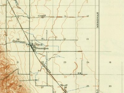
Every edition of the U.S. Geological Survey’s map of Dunnigan. Tap a year, or press play to watch the town change.
1907Dunnigan sheet · 1:62,500
U.S. Geological Survey historical topographic maps (public domain), via Esri’s collection of the scans. The red ring marks the center of Dunnigan.
Every building
Dunnigan, building by building, 1889–1907
Fire insurance maps drew every building, what it was made of and what it was used for, so insurers could price the risk of fire. Pick a year, then a sheet.
1889Sheet 1 of 1
Edition
Sheets
BrickWoodStone
Sanborn Map Company, via the Library of Congress. Editions published in 1930 or earlier, which are in the public domain.
The town of Dunnigan was founded as Antelope by two early settlers, J. S. Copp and Jolin Wilson. During the year 1853 they were living down nearer the Sacramento River, but the winter flood washed them on to higher ground and they settled on new claims here. Next year, A. W. Dunnigan, a Yolo County postal worker, came and gave name to the place. With him were Henry Yarick and Abial Barker, the former going into the hotel business with Dunnigan, the inn being known as "Dunnigan's." Other neighbors were Irving W. and William Brownell, Isaac Rice, D. T. Bird, Harry Porterfield and M. A. Rahm. The first store was opened in 1866 by G. B. Lewis, who sold out to William Earll. Z. J. Brown was the proprietor of a drug and notion store for several years, after which he was succeeded by G. W. Gray. In 1876 the railroad came along, and the town plat of Dunnigan was filed for record at the county s…
Passages that mention Dunnigan, cut from the printed page as they were published.
History of Yolo County, California, with biographical sketches of the leading men and women of the county, who have been identified with its growth and development from the early days to the present1913 · page 58Read the page →
Read the text
1866 by G. B. Lewis, who sold out to William Earll. Z. J. Brown was the proprietor of a drug and notion store for several years, after which he was succeeded by G-. W. Gray. In 1876 the railroad came along, and the town plat of Dunnigan was filed for record at the county seat November 1 of that year. The place on the railroad known as Black's was the pioneer home of J. J. Black, who located there" in 1865. When the road, extending northward towards the Oregon line, reached his farm he
Text read by machine from the scan; it may contain errors.
History of Yolo County, California, with biographical sketches of the leading men and women of the county, who have been identified with its growth and development from the early days to the present1913 · page 663Read the page →
Read the text
For about two seasons after his marriage Mr. Evans lived upon a farm in Ohio, but in 1876 he brought his family to California and settled in Yolo county. During the first four years here he worked on a ranch near Dunnigan and later he purchased one hundred and sixty acres west of the railroad, where he cleared the land, brought the soil under profitable cultivation and engaged in raising grain and stock. Ten busy years were spent on that farm and he then sold, after which he operated leased land for some time, again be-
Text read by machine from the scan; it may contain errors.
Scans and text from the Internet Archive. Books published in 1930 or earlier, which are in the public domain.
Timeline
Dunnigan, 1856 to 1993
Woven from the archive, old maps, post office records, the National Register and the people born here.
Founding dates: Wikidata, Wikipedia, the U.S. post office records of Blevins & Helbock (CC0) and the Census. Homes by year built: Census ACS 2020–24. National Register of Historic Places: National Park Service (list of May 22, 2026). Old photos, postcards and papers: Wikimedia Commons, the Library of Congress and other public archives, credited on each item’s page. Maps: U.S. Geological Survey historical topographic maps (via Esri) and Sanborn fire-insurance maps (Library of Congress). History text and census tables: Wikipedia (CC BY-SA 4.0). Places that used to be: USGS Geographic Names Information System (2021). How TownRatings grades history →
From Wikimedia Commons (1), the National Register of Historic Places (1), Wikipedia, Wikidata and Wikipedia for famous people, U.S. Geological Survey historical maps, the US Post Offices dataset (Blevins & Helbock), the USGS Geographic Names Information System, Sanborn fire insurance maps (Library of Congress) and old county and town histories (Internet Archive). Archive images are copied here with their credits and licenses, shown on each photo’s page. Refreshed monthly.


 2021
