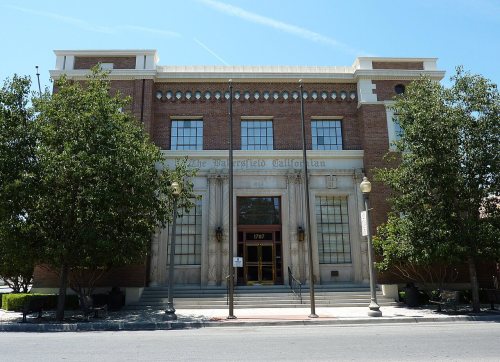
Bakersfield’s post office opened in 1868, and 6 of its places are on the National Register
More historic than 39% of U.S. towns · #234 of 847 in California. What drives it
Most of Bakersfield was built recently: 3% of its homes predate 1940 and the median home dates from 1990. Below: 17 old photos and papers, maps from 1885 on, and the census since 1880.
From Bakersfield’s archive · credits on each photo
Quick answers
How Bakersfield began
When was Bakersfield founded?
1868
The Bakersfield post office opened in 1868, the earliest record of the town by name. Wikidata gives 1869. Two smaller post offices, Panama (1874) and Sumner (1876), opened inside today’s city and later closed.
First census: 801 in 18802020 census: 403,455158 years
How historic is Bakersfield?
C+
More historic than 39% of U.S. towns, on its age, its old homes and the National Register.
Founding year: the first Bakersfield post office (Blevins & Helbock, CC0). Wikidata: 1869.The full story ↓
History grade
What drives Bakersfield’s History grade
On its age, its old homes and the National Register, Bakersfield is more historic than 39% of U.S. towns, #234 of 847 in California. Its National Register listings hold the grade up; its share of homes from before 1940 pulls it down.
C+
HistoryA character grade: shown, never part of Bakersfield’s overall grade.
Among the 400 U.S. cities of 100,000 or more, Bakersfield ranks #272 on History.
Few California towns list much on the Register (a typical California town has 0.0 per 10,000 residents, the U.S. 2.4), so Bakersfield’s 0.2 sits near the middle of its state (65% of California towns have fewer) while its 7 historic buildings outnumber those of 73% of U.S. towns.
Newer cities are common at Bakersfield’s size: in the typical U.S. city of 100,000 or more, 5% of homes predate 1940.
How sure. Graded on any two of the three inputs instead, the letter would range from C− to B−. The pre-1940 share (±0.3 points) is firm at this size. The founding year is the first post office, not a stated founding date; Wikidata’s 1869 falls in the same era, so the grade doesn’t depend on which one is used.
Founding year: the first post office (other dates in Quick answers). Homes: Census ACS 2020–24. National Register: National Park Service, May 2026 list; each listing counted once (boundary changes and added documentation belong to their listing), and a historic district counts its contributing buildings. How TownRatings grades history →
What stands out about Bakersfield’s past
Read from the archive, the National Register and the record. The page puts what stands out first.
Fire insurance maps drew every building, what it was made of and what it was used for, so insurers could price the risk of fire. Pick a year, then a sheet.
1885Sheet 1 of 1
Edition
Sheets
BrickWoodStone
Sanborn Map Company, via the Library of Congress. Editions published in 1930 or earlier, which are in the public domain.
Archaeological evidence indicates the presence of Native American settlements dating back thousands of years. Upon Spanish arrival, present-day Bakersfield was inhabited by the Yowlumne, a Yokuts people. Yowlumne accounts indicate that the village of Woilu was situated in the bounds of the present city.
The Yokuts of the region lived in lodges along the branches of the Kern River delta and hunted antelope, tule elk, deer, bear, fish, and game birds.
In 1776, Spanish missionary Francisco Garcés became the first European to explore the area. Recording his May 1 arrival to a Yokuts village along the Kern River, immediately northeast of present Bakersfield, Garcés wrote,
Passages that mention Bakersfield, cut from the printed page as they were published.
History of Kern County, California, with biographical sketches of the leading men and women of the county who have been identified with its growth and development from the early days to the present1914Read the page →
Read the text
Consolidation of Bakersfield and Kern Occasional movements for the consolidation of Bakersfield and the rival town which the Southern Pacific railroad founded under the name of Sumner and incorporated later under the name of Kern, resulted finally on February 25, 1908, in an election in which the union was defeated by ten votes in Kern, although the voters of Bakersfield approved it by a majority of 342. On December 21, 1909, however, a second election resulted in a vote of 265 for, to 154 against, in Kern, and 518 for, to 186 against, in Bakersfield. The first
Text read by machine from the scan; it may contain errors.
History of Kern County, California, with biographical sketches of the leading men and women of the county who have been identified with its growth and development from the early days to the present1914 · page 183Read the page →
Read the text
McKittrick The town of McKittrick, which is the shipping and trading point for the oil fields of that name, is about forty miles west of Bakersfield. The earliest settlement at that place was called Asphalto, because of an asphalt mine located there in the early days, and the railroad, which was built to the field in 1891. still calls its station by the original name, although everyone else adopted the name McKittrick in 1895. The manufacture of asphaltum was the first industry of the town, and was the means of inducing the Southern Pa-
Text read by machine from the scan; it may contain errors.
Scans and text from the Internet Archive. Books published in 1930 or earlier, which are in the public domain.
Timeline
Bakersfield, 1868 to 1971
Woven from the archive, old maps, post office records, the National Register and the people born here.
Nothing in the archives for these yearsWeddings on Main Street, storms, parades, school pictures, the old store. If it’s in your family album, it belongs here.
The Bakersfield post office opened in 1868, the earliest record of the town by name (U.S. post office records). Wikidata gives 1869.
How does Bakersfield rank for history?
Bakersfield is more historic than 39% of U.S. towns, #234 of 847 in California. The History grade combines the town’s founding era, the share of homes built before 1940 and its National Register listings. It’s a character grade, so it isn’t part of the overall grade. How it works.
What is on the National Register in Bakersfield?
6 listings: 6 buildings, among them the First Baptist Church (listed 1979, the first). 7 historic buildings in all.
How old are the homes in Bakersfield?
3% of Bakersfield’s homes were built before 1940 (Census estimate), against a typical 3.4% for a California town; the median home was built in 1990.
Founding dates: Wikidata, Wikipedia, the U.S. post office records of Blevins & Helbock (CC0) and the Census. Homes by year built: Census ACS 2020–24. National Register of Historic Places: National Park Service (list of May 22, 2026). Old photos, postcards and papers: Wikimedia Commons, the Library of Congress and other public archives, credited on each item’s page. Maps: U.S. Geological Survey historical topographic maps (via Esri) and Sanborn fire-insurance maps (Library of Congress). History text and census tables: Wikipedia (CC BY-SA 4.0). Places that used to be: USGS Geographic Names Information System (2021).
From Wikimedia Commons (7), the Library of Congress (10), Wikidata (1), the National Register of Historic Places (6), Wikipedia, Wikidata and Wikipedia for famous people, U.S. Geological Survey historical maps, U.S. Census counts (via Wikipedia), the US Post Offices dataset (Blevins & Helbock), the USGS Geographic Names Information System, Sanborn fire insurance maps (Library of Congress) and old county and town histories (Internet Archive). Archive images are copied here with their credits and licenses, shown on each photo’s page. Refreshed monthly.


 1888
 1890
 1890
 1910
 1919
 1919
 1919
 1923
 1923
 1923
 1923