
Sawtooth National Forest
Sawtooth National Forest is a national forest that covers 2,110,408 acres (854,052 ha) in the U.S. states of Idaho (~96 percent) and Utah (~4 percent). On the map, it sits 15 mi west of Ketchum. It dates back to 1905.

A national forest, 15 mi west of Ketchum
Winters are cold
January nights drop to 8°, with about 102" of snow a year. When to go ↓
Ketchum is the nearest base
Ketchum is 15 miles east, with 24 places to stay. Where to stay ↓
Established in 1905
Sawtooth National Forest dates from 1905. About ↓
Best months: Jul and Aug
July and August are the mild months, with highs of 81–83°. When to go ↓
Written from NOAA 1991–2020 normals, Overture places to stay, Census town figures, Wikidata and Wikipedia.
The climate here
The weather near Sawtooth National Forest shifts through the year, as below.
Sawtooth National Forest
Sawtooth National Forest is a national forest that covers 2,110,408 acres (854,052 ha) in the U.S. states of Idaho (~96 percent) and Utah (~4 percent). Managed by the U.S. Forest Service in the U.S. Department of Agriculture, it was originally named the Sawtooth Forest Reserve in a proclamation issued by President Theodore Roosevelt on May 29, 1905. On August 22, 1972, a portion of the forest was designated as the Sawtooth National Recreation Area (SNRA), which includes the Sawtooth, Cecil D. Andrus–White Clouds, and Hemingway–Boulders wilderness areas. The forest is managed as four units: the SNRA and the Fairfield, Ketchum, and Minidoka Ranger Districts.
- Type
- National forest
- Established
- 1905
- Area
- 2,819 square miles
- Wikipedia readers
- 6.6K a year
Rooms near Sawtooth National Forest
Nearest for a night are Ketchum (24) and Sun Valley (9).
- 1Sun Valley - Bald Mountain
- 2Sawtooth
- 3Soldier Mountain
- 4Sun Valley - Dollar Mountain
- 5Sawtooth Botanical Garden
Ketchum
The closest town with somewhere to stay.
3,643 people · 43% vacation homes
15 mi east of Sawtooth National Forest
Compare 5 towns
| Town | From Sawtooth National Forest | Drive | Places to stay | People | Typical home | Safety |
|---|---|---|---|---|---|---|
| Ketchum 43% vacation homes | 15 mi east | 25 min | 24 15 hotels · 1 motel · 1 inn or B&B · 7 lodges & cabins | 3,643 | $824K | B |
| Sun Valley 65% vacation homes | 17 mi east | 25 min | 9 4 hotels · 2 inns & B&Bs · 2 lodges & cabins · 1 campground | 1,776 | $963K | A |
| Hailey | 24 mi southeast | 35 min | 11 8 hotels · 1 inn or B&B · 1 lodge or cabins · 1 RV park | 10,053 | $638K | — |
| Bellevue | 28 mi southeast | 40 min | 3 1 hotel · 1 motel · 1 RV park | 2,597 | $539K | A− |
| Fairfield | 28 mi south | 40 min | 2 1 hotel · 1 inn or B&B | 501 | $250K | — |
Getting there
Nearest airports with airline service
Other places close by
A wider trip can take in these, within 67 miles.
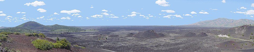 58 mi National PreserveCraters of the Moon National Preserve251K visitors a year
 52 mi MountainBorah Peak115 mi Ski areaSun Valley - Bald Mountain143 runs · 3,363 ft vertical
 225 mi Park & preserveSawtooth National Recreation Area319 mi Ski areaSoldier Mountain Ski Area41 runs · 1,393 ft vertical416 mi Ski areaSun Valley - Dollar Mountain28 runs · 621 ft vertical
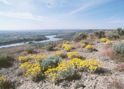 67 mi National MonumentHagerman Fossil Beds National Monument37K visitors a year
 517 mi GardenSawtooth Botanical Garden
Photo credits
Craters of the Moon National Preserve: Unknown, CC BY-SA 3.0 · Borah Peak: Leaflet, Public domain · Sawtooth National Recreation Area: Fredlyfish4, CC BY-SA 4.0 · Hagerman Fossil Beds National Monument: NPS photo, Public domain · Sawtooth Botanical Garden: Miguel Vieira from Walnut Creek, CA, USA, CC BY 2.0


Questions people have about Sawtooth National Forest
What town is Sawtooth National Forest near?
Ketchum, ID, about 15 miles east.
When is the best time to visit Sawtooth National Forest?
July and August, with highs of 81–83°.
What is the closest airport to Sawtooth National Forest?
Friedman Memorial (SUN), about 24 miles away. The nearest big hub is Boise Air Terminal/Gowen Field (BOI), about 79 miles.
Where should I stay near Sawtooth National Forest?
Ketchum (15 mi, 24 places to stay), Sun Valley (17 mi, 9 places to stay) and Hailey (24 mi, 11 places to stay).
Local know-how from Ketchum
Share what you know in Ketchum’s Town Square.
Sources: National Park Service · ski areas © OpenSkiMap / OpenStreetMap contributors · Wikidata · Wikipedia readership · NOAA climate normals · U.S. Census.