
Big Hole National Battlefield
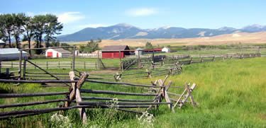
Big Hole National Battlefield preserves a battlefield in the western United States, located. Its location is 10 mi west of Wisdom. It comes under the National Park Service.

A national battlefield, 10 mi west of Wisdom
74% of visits come in Jun–Sep
July is the busiest month, with about 10,076 visitors. December sees about 327. When to go ↓
Winters are cold
January nights drop to 7°. When to go ↓
Plan where you’ll sleep
The nearest town with many places to stay is Anaconda-Deer Lodge County, 40 miles northeast. Where to stay ↓
Best month: Jul
July is the mild month, with a high of 77°. When to go ↓
Written from National Park Service visitor counts, NOAA 1991–2020 normals, Overture places to stay, Census town figures, Wikidata and Wikipedia. Updated when the Park Service posts a new month.
Busy months and weather
Crowds at Big Hole rise and fall through the year, as below.
Big Hole National Battlefield
Big Hole National Battlefield preserves a battlefield in the western United States, located in Beaverhead County, Montana. In 1877, the Nez Perce fought a delaying action against the U.S. Army's 7th Infantry Regiment here on August 9 and 10, during their failed attempt to escape to Canada. This action, the Battle of the Big Hole, was the largest battle fought between the Nez Perce and U.S. government forces in the five-month conflict known as the Nez Perce War.
In 1992, the park was made a part of Nez Perce National Historical Park, which consists of 38 locations in five states, following the flight of the Nez Perce tribe from the U.S. military, the route of which was designated Nez Perce National Historic Trail in 1986.
- Type
- National Battlefield
- Elevation
- 6,165 ft
- Run by
- National Park Service
- Listed
- National Register of Historic Places (1966)
- Wikipedia readers
- 5.8K a year
- Official site
- nps.gov/biho
Opening times and entry
Places to stay near Big Hole National Battlefield
Hotels, motels or campgrounds are closest in Wisdom (4) and Maverick Mountain (4), and Anaconda-Deer Lodge County has the most rooms in the area (24).
Wisdom
The closest town with somewhere to stay.
110 people · 24% vacation homes
10 mi east of Visitor Center at Big Hole National Battlefield · 9 mi to the park
Maverick Mountain
73 people · 52% vacation homes
30 mi southeast of Visitor Center at Big Hole National Battlefield · 29 mi to the park
Conner
147 people
31 mi northwest of Visitor Center at Big Hole National Battlefield · 30 mi to the park
Sula
9 people
21 mi northwest of Visitor Center at Big Hole National Battlefield · 20 mi to the park
Anaconda-Deer Lodge County
The most places to stay in the area, and a base for a longer trip.
9,709 people
40 mi northeast of Visitor Center at Big Hole National Battlefield · 39 mi to the park
Compare 6 towns
| Town | From the visitor center | Drive | Places to stay | People | Typical home |
|---|---|---|---|---|---|
| Wisdom 24% vacation homes | 10 mi east | 15 min | 4 1 motel · 2 lodges & cabins · 1 RV park | 110 | — |
| Maverick Mountain 52% vacation homes | 30 mi southeast | 45 min | 4 2 hotels · 1 inn or B&B · 1 lodge or cabins | 73 | $375K |
| Conner | 31 mi northwest | 45 min | 4 2 inns & B&Bs · 2 lodges & cabins | 147 | — |
| Sula | 21 mi northwest | 30 min | 1 1 campground | 9 | — |
| Jackson 25% vacation homes | 22 mi southeast | 35 min | 1 1 lodge or cabins | 61 | — |
| Anaconda-Deer Lodge County | 40 mi northeast | 1 hr | 24 5 hotels · 4 motels · 3 inns & B&Bs · 9 lodges & cabins · 1 hostel · 2 RV parks | 9,709 | $232K |
Getting there
Nearest airports with airline service, from the visitor center
More to see nearby
These lie within 69 miles as the crow flies.
 61 mi LakeBerkeley Pit
 59 mi MuseumDumas Brothel116 mi Ski areaLost Trail56 runs · 1,758 ft vertical47 mi Ski areaDiscovery Ski Area50 runs · 2,443 ft vertical
 62 mi Theme parkColumbia Gardens
 69 mi National Historic SiteGrant-Kohrs Ranch National Historic Site24K visitors a year229 mi Ski areaMaverick Mountain Ski Area19 runs · 1,579 ft vertical58 mi MuseumWorld Museum of Mining
Photo credits
Berkeley Pit: Cybergrl23, CC BY-SA 3.0 · Dumas Brothel: Acroterion, CC BY-SA 4.0 · Columbia Gardens: Unknown authorUnknown author, Public domain · Grant-Kohrs Ranch National Historic Site: National Park Service, Public domain


40,938 people came in 2025
The chart runs from 2016 to 2025.
Big Hole in questions
What town is Big Hole National Battlefield near?
Wisdom, MT, about 10 miles east.
When is the best time to visit Big Hole National Battlefield?
July, with a high of 77°. July is the busiest month (about 10,076 visitors).
How many people visit Big Hole National Battlefield each year?
40,938 in 2025, according to the National Park Service. The record is 56,943, set in 2018.
What is the closest airport to Big Hole National Battlefield?
Lemhi County (SMN), about 38 miles away. The nearest big hub is Boise Air Terminal/Gowen Field (BOI), about 192 miles.
Where should I stay near Big Hole National Battlefield?
Wisdom (10 mi, 4 places to stay), Anaconda-Deer Lodge County (40 mi, 24 places to stay) and Maverick Mountain (30 mi, 4 places to stay).
Questions for Wisdom
Nobody has posted a tip yet; ask or answer in Wisdom’s Town Square.
Sources: National Park Service · ski areas © OpenSkiMap / OpenStreetMap contributors · Wikidata · Wikipedia readership · National Park Service visitor use statistics · NOAA climate normals · U.S. Census.