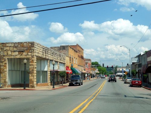
Ozark’s post office opened in 1836, and 7 of its places are on the National Register
More historic than 72% of U.S. towns · #17 of 123 in Arkansas. What drives it
Most of Ozark was built recently: 4% of its homes predate 1940 and the median home dates from 1981. 7 places in town are on the National Register, among them a historic district with 32 buildings. Below: maps from 1886 on and the census since 1850.
Founding year: the first Ozark post office (Blevins & Helbock, CC0).The full story ↓
History grade
What drives Ozark’s History grade
On its age, its old homes and the National Register, Ozark is more historic than 72% of U.S. towns, #17 of 123 in Arkansas. Its National Register listings hold the grade up; its share of homes from before 1940 pulls it down.
B+
HistoryA character grade: shown, never part of Ozark’s overall grade.
Arkansas towns list more on the Register than most of the country (a typical Arkansas town has 20.5 per 10,000 residents, the U.S. 2.4), so Ozark’s 107 sits above most of its state (86% of Arkansas towns have fewer) while its 38 historic buildings outnumber those of 83% of U.S. towns.
How sure. Graded on any two of the three inputs instead, the letter would range from B− to A. The pre-1940 share is a Census survey estimate (±3.7 points). The founding year is the first post office, not a stated founding date.
Founding year: the first post office (other dates in Quick answers). Homes: Census ACS 2020–24. National Register: National Park Service, May 2026 list; each listing counted once (boundary changes and added documentation belong to their listing), and a historic district counts its contributing buildings. How TownRatings grades history →
What stands out about Ozark’s past
Read from the archive, the National Register and the record. The page puts what stands out first.
Every edition of the U.S. Geological Survey’s map of Ozark. Tap a year, or press play to watch the town change.
1887Magazine Mountain #2 sheet · 1:62,500
U.S. Geological Survey historical topographic maps (public domain), via Esri’s collection of the scans. The red ring marks the center of Ozark.
Every building
Ozark, building by building, 1886–1914
Fire insurance maps drew every building, what it was made of and what it was used for, so insurers could price the risk of fire. Pick a year, then a sheet.
1886Sheet 1 of 1
Edition
Sheets
BrickWoodStone
Sanborn Map Company, via the Library of Congress. Editions published in 1930 or earlier, which are in the public domain.
Native Americans roamed the area freely before Arkansas was a territory. The Cherokee and Osage lived in this area that would later become attractive to settlers. The Ozark area was frequented by French fur trappers and served as a landmark during European exploration of the area. It was these adventurous souls who gave the area and the rolling mountains that rise there their name, Aux Arcs.
Included in the Louisiana Purchase of 1803, the vicinity became a stopping and crossing point along the Arkansas River. The modern settlement of Ozark was established here in the 1830s, and an important road grew connecting Ozark to Fayetteville, Arkansas, following the route of today's Pig Trail Scenic Byway to connect Northwest Arkansas with the river.
Passages that mention Ozark, cut from the printed page as they were published.
A reminiscent history of the Ozark region1894 · page 384Read the page →
Read the text
Company F, Fourteenth Missouri Regiment, under Col. John M. Richardson, and served out one year. He was ina number of skirmishes with Marmaduke and was in the fight at Springfield. After leaving the army he started a store at Ozark, but at the same time continued to till the soil. For fifteen years he sold goods in Ozark, and was then engaged in farming and stock trading up to 1887, when he and John Schonook, of Springfield, built the mill at Ozark.
Text read by machine from the scan; it may contain errors.
A reminiscent history of the Ozark region1894 · page 207Read the page →
Read the text
Militia, after which he was in the Sixth Provisional Regiment until the spring of 1864, when he was detailed home to raise a corps, and in the fall of that year joined the Forty-sixth Missouri Infantry as second lieutenant of Company I, and was thereafter in Ozark County and at Springfield the most of the time. He was a brave and faithful supporter of the Union cause, and after the war was made sheriff of Ozark County, and at the election of 1866 was elected to the office for two years and again in 1874. In 1884 he was elected to the Legislature on the Democrat ticket and served on the Committees on
Text read by machine from the scan; it may contain errors.
Scans and text from the Internet Archive. Books published in 1930 or earlier, which are in the public domain.
Timeline
Ozark, 1836 to 1992
Woven from the archive, old maps, post office records, the National Register and the people born here.
The Ozark post office opened in 1836, the earliest record of the town by name (U.S. post office records).
How does Ozark rank for history?
Ozark is more historic than 72% of U.S. towns, #17 of 123 in Arkansas. The History grade combines the town’s founding era, the share of homes built before 1940 and its National Register listings. It’s a character grade, so it isn’t part of the overall grade. How it works.
What is on the National Register in Ozark?
7 listings: 6 buildings, among them the Franklin County Jail (listed 1982, the first), and 1 historic district, the Ozark Courthouse Square Historic District, with 32 contributing buildings. 38 historic buildings in all.
How old are the homes in Ozark?
4% of Ozark’s homes were built before 1940 (Census estimate, ±3.7 points), against a typical 3.1% for an Arkansas town; the median home was built in 1981.
Founding dates: Wikidata, Wikipedia, the U.S. post office records of Blevins & Helbock (CC0) and the Census. Homes by year built: Census ACS 2020–24. National Register of Historic Places: National Park Service (list of May 22, 2026). Old photos, postcards and papers: Wikimedia Commons, the Library of Congress and other public archives, credited on each item’s page. Maps: U.S. Geological Survey historical topographic maps (via Esri) and Sanborn fire-insurance maps (Library of Congress). History text and census tables: Wikipedia (CC BY-SA 4.0). Places that used to be: USGS Geographic Names Information System (2021).
From Wikimedia Commons (18), the National Register of Historic Places (7), Wikipedia, Wikidata and Wikipedia for famous people, U.S. Geological Survey historical maps, U.S. Census counts (via Wikipedia), the US Post Offices dataset (Blevins & Helbock), the USGS Geographic Names Information System, Sanborn fire insurance maps (Library of Congress) and old county and town histories (Internet Archive). Archive images are copied here with their credits and licenses, shown on each photo’s page. Refreshed monthly.


 2024
 2014
 2013
 2013
 2013
 2013
 2013
 2013
 2011
 2011
 2011
 2010
 2009
 2009
 2009
 2009
 2008
 2006