Enterprise’s post office opened in 1870, and 3 of its places are on the National Register
More historic than 30% of U.S. towns · #108 of 187 in Alabama. What drives it
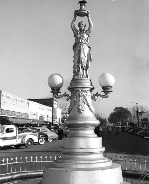
Most of Enterprise was built recently: 2% of its homes predate 1940 and the median home dates from 1989. Its Register listings are the Boll Weevil Monument, the Seaboard Coastline Depot and the Rawls Hotel. Below: 10 old photos and papers, maps from 1905 on, and the census since 1900.
The Enterprise post office opened in 1870, the earliest record of the town by name. Wikidata gives 1896. Another post office, Keyton (1892), opened inside today’s city and later closed.
First census: 610 in 19002020 census: 28,711156 years
How historic is Enterprise?
C
More historic than 30% of U.S. towns, on its age, its old homes and the National Register.
Founding year: the first Enterprise post office (Blevins & Helbock, CC0). Wikidata: 1896.The full story ↓
History grade
What drives Enterprise’s History grade
On its age, its old homes and the National Register, Enterprise is more historic than 30% of U.S. towns, #108 of 187 in Alabama. Its National Register listings hold the grade up; its share of homes from before 1940 pulls it down.
C
HistoryA character grade: shown, never part of Enterprise’s overall grade.
Alabama towns list about as much on the Register as the country (a typical Alabama town has 2.7 per 10,000 residents, the U.S. 2.4), so Enterprise’s 1.0 sits near the middle of its state (53% of Alabama towns have fewer) while its 3 listings outnumber those of 65% of U.S. towns.
How sure. Graded on any two of the three inputs instead, the letter would range from C− to C+. The pre-1940 share (±0.7 points) is firm at this size. The founding year is the first post office, not a stated founding date; Wikidata’s 1896 falls in the same era, so the grade doesn’t depend on which one is used.
Founding year: the first post office (other dates in Quick answers). Homes: Census ACS 2020–24. National Register: National Park Service, May 2026 list; each listing counted once (boundary changes and added documentation belong to their listing), and a historic district counts its contributing buildings. How TownRatings grades history →
What stands out about Enterprise’s past
Read from the archive, the National Register and the record. The page puts what stands out first.
Lost post offices, old corners, places now gone and burying grounds
Enterprise’s post office has been open since 1870. Another post office, Keyton, opened and closed inside today’s town.
Enterprise
1870–today
Keyton
1892–1903
18701950today
Hamlets and corners on the map
Alpha HeightsBoland AcresBriarhill AcresChateau CourtClubview EstatesCollege HeightsCoppinvilleCountry Club EstatesCountry Club MeadowsDeerfield ParkFairfield EstatesForest ParkFoxhillGateway EstatesGreen AcresGriffin HeightsHarrand Creek EstatesHillcrestHoneysuckle HillsIdlewoodIndian LakesIndian SpringsIndigoJamestown Colony
Gone or out of use
Camp Ground SchoolschoolEnterprise HospitalhospitalFriendship Baptist ChurchchurchKeyton SchoolschoolMount Zion Churchchurch
4cemeteries and burying grounds inside Enterprise
Enterprise CityMount ZionMount ZionSalem
US Post Offices dataset (Blevins & Helbock, CC0). Places and cemeteries from the USGS Geographic Names Information System (2021).
Every building
Enterprise, building by building, 1905–1929
Fire insurance maps drew every building, what it was made of and what it was used for, so insurers could price the risk of fire. Pick a year, then a sheet.
The founder of Enterprise, John Henry Carmichael, first settled there in 1881. Carmichael opened a store, which attracted more settlers to the area, and by the next year, a post office was relocated from the settlement of Drake Eye to the north to Enterprise. In 1896, with 250 people having settled there, the city of Enterprise incorporated. Soon afterward, the Alabama Midland Railway came to Enterprise, bringing with it opportunities for commerce and growth. By 1906, its population had grown to 3,750.
Nothing in the archives for these yearsWeddings on Main Street, storms, parades, school pictures, the old store. If it’s in your family album, it belongs here.
Nothing in the archives for these yearsWeddings on Main Street, storms, parades, school pictures, the old store. If it’s in your family album, it belongs here.
Nothing in the archives for these yearsWeddings on Main Street, storms, parades, school pictures, the old store. If it’s in your family album, it belongs here.
The Enterprise post office opened in 1870, the earliest record of the town by name (U.S. post office records). Wikidata gives 1896.
How does Enterprise rank for history?
Enterprise is more historic than 30% of U.S. towns, #108 of 187 in Alabama. The History grade combines the town’s founding era, the share of homes built before 1940 and its National Register listings. It’s a character grade, so it isn’t part of the overall grade. How it works.
What is on the National Register in Enterprise?
Three places: the Boll Weevil Monument (listed 1973), the Seaboard Coastline Depot (1974) and the Rawls Hotel (1980).
How old are the homes in Enterprise?
2% of Enterprise’s homes were built before 1940 (Census estimate), against a typical 3.2% for an Alabama town; the median home was built in 1989.
Founding dates: Wikidata, Wikipedia, the U.S. post office records of Blevins & Helbock (CC0) and the Census. Homes by year built: Census ACS 2020–24. National Register of Historic Places: National Park Service (list of May 22, 2026). Old photos, postcards and papers: Wikimedia Commons, the Library of Congress and other public archives, credited on each item’s page. Maps: U.S. Geological Survey historical topographic maps (via Esri) and Sanborn fire-insurance maps (Library of Congress). History text and census tables: Wikipedia (CC BY-SA 4.0). Places that used to be: USGS Geographic Names Information System (2021).
From Wikimedia Commons (5), the Library of Congress (6), Wikidata (1), the National Register of Historic Places (3), Wikipedia, Wikidata and Wikipedia for famous people, U.S. Geological Survey historical maps, U.S. Census counts (via Wikipedia), the US Post Offices dataset (Blevins & Helbock), the USGS Geographic Names Information System and Sanborn fire insurance maps (Library of Congress). Archive images are copied here with their credits and licenses, shown on each photo’s page. Refreshed monthly.




 1880
 1880
 1939
 1939
 1939
 1939
 1939
 2007