
Oddfellows House · National Register of Historic Places
Farmers Loop’s story
Farmers Loop in pictures
The archive holds 3 maps from 1949 on.
2 places on the National Register of Historic Places.
Explore the history →Each edition grades its towns against each other only.
A town of 4,954.
Farmers Loop is a solid, middle-of-the-road choice. It grades B+ overall, 6th among Alaska's 41 graded towns, with no subject far below average. Its best mark is health: CDC estimates put its residents' health ahead of 83% of the country. It also does better than most on incomes: the median household earns $110K. Its lowest everyday mark is in cost of living: the typical home is worth about $280K, 3.2 years of the Fairbanks metro’s $88K median household income. Farmers Loop’s January low is -12°F, where Alaska’s towns sit at 7°F and U.S. towns at 22°F. Creamer's Field Migratory Waterfowl Refuge, at 1,417 acres with 21.5 miles of trail, is the biggest park or preserve.
Where Farmers Loop beats most towns.
Each subject compared with towns across the country (schools within Alaska), ordered by how far Farmers Loop is from typical.
How TownRatings grades towns →
The archive holds 3 maps from 1949 on.
2 places on the National Register of Historic Places.
Explore the history →Farmers Loop is unincorporated, so Fairbanks North Star Borough and regional agencies provide most services.
EPA SDWIS (Oct 9, 2026) · HIFLD + EIA-861 2025 · Census 2020 ZCTAs · NCES 2024–25 · registration: vote.gov, updated Sep 30, 2026.
Ordered by what stands out in Farmers Loop.
Farmers Loop has more trail for its size than nearly any town in Alaska, has a shorter frost-free season than nearly all U.S. towns and has less food insecurity than most of Alaska.
At 2.4 miles of trail per square mile, it ranks #2 of 40 Alaska towns.
51 miles of trail in 2 parks and preserves. Farmers Loop’s trail density is 2.4 miles per square mile.
| Biggest places to walk | Trails | Acres |
|---|---|---|
| 1. Creamer's Field Migratory Waterfowl Refuge | 21.5 mi | 1,417 |
| 2. Goldstream Public Use Area | 3.8 mi | 1,001 |
Trails & parks © OpenStreetMap contributors · Conserved land: USGS PAD-US
Its widest gap with Alaska is food insecurity: 8.7% of its 3,620 adults worry about having enough food, against 14.3% statewide.
68% of Farmers Loop adults had a checkup this year. Farmers Loop beats the Alaska average on 11 of 32 CDC measures and trails it on 1. 8.1% of Farmers Loop adults have diabetes.
| Farmers Loop | Alaska towns | U.S. towns | |
|---|---|---|---|
| Yearly checkup (CDC PLACES) | 68% | 68% | 79% |
| Diabetes (CDC PLACES) | 8.1% | 8.8% | 12% |
| Frequent physical distress (CDC PLACES) | 12% | 13% | 14% |
| Frequent mental distress (CDC PLACES) | 15% | 16% | 17% |
| What stands out | Farmers Loop | AK |
|---|---|---|
| Fewer adults facing food insecurity | 8.7% | 14.3% |
| Fewer adults facing a utility shut-off | 5.5% | 8.2% |
| More adults who have had cancer | 7.8% | 7% |
CDC PLACES 2025 · modeled estimates for adults · CMS · HRSA
The College Obsy weather station, 6 miles away, records that the frost-free season runs about 111 days, shorter than in 98% of U.S. towns. January nights average -11.5°, colder than in 100% of U.S. towns; July afternoons average 71.3°.
Farmers Loop has cold, snowy winters and cool summers, with very little rain. The July high in Farmers Loop is 71°F. About 64 inches of snow falls in a winter.
NOAA U.S. Climate Normals, 1991–2020
Expected storm and flood damage is higher than in 66% of U.S. communities.
FEMA National Risk Index · OpenFEMA
No broad age group is more than 4 points off the Alaska average. 13% of residents are 65 or older in Farmers Loop. 33% of adults 25 and older have a bachelor’s degree or more, vs 32% across Alaska.
| Farmers Loop | Alaska towns | U.S. towns | |
|---|---|---|---|
| Aged 65 or older | 13% | 13% | 18% |
| Median age | 36.6 years | 37 years | 40.5 years |
| Bachelor’s degree or more, 25+ | 33% | 27% | 29% |
| Under 18 | 24% | 24% | 22% |
50% women, 50% men
That’s an even split within the survey’s margin of ±4.3 points. Across Alaska, 47.5% of residents are women. Among residents 18 to 24, 97% are men (AK 57%).
| Farmers Loop | AK | U.S. | |
|---|---|---|---|
| Under 10 | 15.3% | 13.2% | 11.6% |
| 10 to 17 | 8.9% | 10.9% | 10.3% |
| 18 to 24 | 6.4% | 9.2% | 9.1% |
| 25 to 34 | 17.6% | 15.4% | 13.7% |
| 35 to 44 | 14.4% | 14.2% | 13.2% |
| 45 to 54 | 10.9% | 11.3% | 12.2% |
| 55 to 64 | 13.7% | 11.9% | 12.7% |
| 65 to 74 | 6.8% | 9.2% | 10.2% |
| 75 and older | 6% | 4.6% | 7% |
| No diploma | 3.8% | 6.4% | 10.4% |
| High school | 40.9% | 28.9% | 26% |
| Some college | 10.1% | 24% | 19.1% |
| Associate’s | 11.9% | 9.1% | 8.8% |
| Bachelor’s | 22.6% | 19.8% | 21.6% |
| Graduate | 10.7% | 11.8% | 14.1% |
U.S. Census Bureau · ACS 2020-2024 5-year estimates · in a town of 5,000, single groups can be off by several points
Zillow Home Value Index · Redfin Data Center
Museums, parks, gardens and other places to visit around Farmers Loop. Close and well known come first.
 5 mi Park & preservePioneer Park
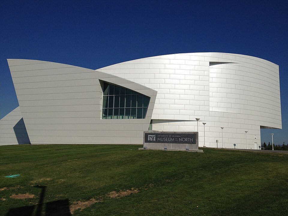 5 mi MuseumUniversity of Alaska Museum of the North8 mi Ski areaMoose Mountain Ski Resort98 runs · 1,311 ft vertical13 mi Ski areaSki Land (Mt Aurora)45 runs · 1,084 ft vertical
 6 mi GardenGeorgeson Botanical Garden
Pioneer Park: Enrico Blasutto, CC BY-SA 4.0 · University of Alaska Museum of the North: Maureen amerune, CC BY 2.0 · Georgeson Botanical Garden: Abalg, CC BY-SA 4.0
1 within 15 miles of the center of Farmers Loop
About 5 of every 100 Farmers Loop residents are enrolled in college, about the same as Alaska.
2 places in Farmers Loop on the National Register of Historic Places.
Census-designated place in Alaska, United States
Farmers Loop is a census-designated place in Fairbanks North Star Borough, Alaska, United States. It was one of several CDPs created out of various Fairbanks suburbs and outskirts during the 2010 census. As of the 2020 census, Farmers Loop had a population of 4,704. The CDP is located north of Fairbanks and is centered on and named for Farmers Loop Road, a road that runs along the foothills north of Fairbanks between the Steese Highway and the northeastern corner of the University of Alaska Fairbanks campus. According to the U.S. Census Bureau, the Farmers Loop CDP has a total area of 21.90 square miles (56.71 km2), of which 21.87 square miles (56.65 km2) is land and 0.02 square miles (0.06…
From Wikipedia, licensed CC BY-SA 4.0 · facts via Wikidata (CC0)
4 towns share a border with Farmers Loop.
| Town | AK rank | Overall | Cost | Safety | Schools | Health |
|---|---|---|---|---|---|---|
| Farmers Loop | #6 | B+ | C+ | — | B | A− |
| Goldstream | #7 | B | B+ | — | B | A |
| College | #13 | B | C | — | B | A− |
| Fox | — | — | — | — | — | — |
| Steele Creek | #5 | B+ | B− | — | B | A |
Farmers Loop, Goldstream, College and Steele Creek report no FBI crime data of their own. Fox isn’t graded (fewer than 1,000 residents, or not enough data). Compare Farmers Loop with a neighbor →
Short answers, built from the data on this page.
By most measures, yes. Farmers Loop grades B+ overall, better than 65% of U.S. towns and #6 of 41 in Alaska. It grades A− for health and B for schools.
The typical home is worth about $280,000, 30% below the Alaska typical home. Cost of living, which also weighs rents, property taxes and how many households pay 30% or more of their income for housing, grades C+.


