
Ventnor Botanic Garden
Ventnor Botanic Garden is a botanical garden. Within the built-up area of Ventnor, it is one of the places to visit. It is protected as a Grade II listed park and garden.
Garden in Ventnor
Inside Ventnor
Ventnor Botanic Garden is inside Ventnor’s built-up area, with 7 more places to visit within 5 km. Towns near it ↓
Grade II listed park and garden
On the official list of protected heritage; Ventnor has 117 listed buildings in all, on its History page. About ↓
Written from OpenStreetMap, Wikidata, the ONS built-up areas and Met Office 1991–2020 averages.
Month by month in Ventnor
If warmth matters, go June to September: Ventnor reaches 19–21°C.
Ventnor Botanic Garden
4 Wikipedia editions have an article on it. Top of the 57 other places within 15 km is Carisbrooke Castle, 12 km off.
- Type
- Garden
- Listed
- Grade II listed park and garden
- Wikipedias
- Covered in 4 languages
- Town
- in Ventnor
- Official site
- botanic.co.uk
Where it sits
Ventnor Botanic Garden is in orange, with the places near it numbered as below.
© OpenStreetMap contributors · The dashed line is Ventnor’s built-up area. · ONS built-up area 2022
Towns within reach of Ventnor Botanic Garden
The largest of the 6 towns is Shanklin, with 9,112 people. The towns whose pages list it: the one it is in, those within 5 km of it, then larger towns further out.
Ventnor
Wroxall
Whitwell
Niton
Compare the 6 towns
Each has its own grades, prices and things to do.
Make a day of it near Ventnor Botanic Garden
Of the 57 within 15 km, look for 2 historic houses, 2 museums and a castle.
 Castle · English HeritageCarisbrooke Castle12 km away2
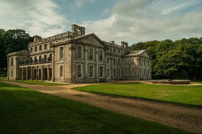 Historic house · English HeritageAppuldurcombe House3.1 km away3
 Theme parkBlackgang Chine Theme Park5.9 km away4
 Wildlife parkAmazon World7.4 km away5
 MuseumIsle of Wight Steam Railway13 km away6
 MuseumDinosaur Isle9.8 km away7
 Historic houseRylstone Manor5.5 km away8Park or estatePark or estate · National TrustVentnor Downs2.6 km away
Within 15 km, close and well known first. Numbers match the map.
Questions people have about Ventnor Botanic Garden
Where is Ventnor Botanic Garden?
Ventnor Botanic Garden is in Ventnor, Isle of Wight, inside the town’s built-up area.
What is Ventnor Botanic Garden?
Botanical garden.
When is the best time to visit Ventnor Botanic Garden?
June to September are the warmest months in Ventnor, with afternoon highs of 19–21°C (Met Office 1991–2020 averages).
Is Ventnor Botanic Garden a listed building?
Yes: Grade II listed park and garden.
What else is there to see near Ventnor Botanic Garden?
Within 15 km: Carisbrooke Castle (12 km), Appuldurcombe House (3.1 km), Blackgang Chine Theme Park (5.9 km) and Amazon World (7.4 km).
Places: OpenStreetMap (© OpenStreetMap contributors, Open Database Licence) and Wikidata (CC0), placed in the ONS 2022 built-up area (Open Government Licence v3.0). Visitor counts are the latest Wikidata gives, with their year.
Photos: each place’s Wikidata image, from Wikimedia Commons under the licence below (our copy, resized).
Photo credits (8)
- Ventnor Botanic Garden: Shaun Ferguson, CC BY-SA 2.0, Wikimedia Commons
- Carisbrooke Castle: DeFacto, CC BY-SA 4.0, Wikimedia Commons
- Appuldurcombe House: Cpsterling, CC BY-SA 3.0, Wikimedia Commons
- Blackgang Chine Theme Park: Mypix, CC BY-SA 4.0, Wikimedia Commons
- Amazon World: Lewis Clarke, CC BY-SA 2.0, Wikimedia Commons
- Isle of Wight Steam Railway: Stephen Dawson, CC BY-SA 2.0, Wikimedia Commons
- Dinosaur Isle: Editor5807, Public domain, Wikimedia Commons
- Rylstone Manor: DAVID M GOODWIN, CC BY-SA 2.0, Wikimedia Commons
Contains public sector information licensed under the Open Government Licence v3.0. Contains HM Land Registry data © Crown copyright and database right 2026. Contains OS data © Crown copyright and database right 2026 (ONS boundaries). Northern Ireland: Source: NISRA; contains Land & Property Services data and Ordnance Survey of Northern Ireland information, © Crown copyright, licensed under the Open Government Licence v3.0. Scotland: contains National Records of Scotland data, Registers of Scotland data and SEPA data, © Crown copyright / © SEPA 2025, licensed under the Open Government Licence v3.0.