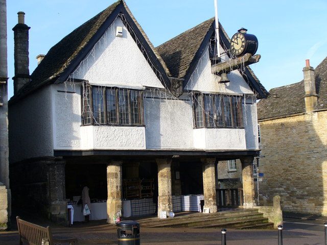
Tolsey Museum
Tolsey Museum is a museum, formerly town hall and market hall, in Burford, West Oxfordshire. It is on the official list as a Grade II* listed building. Look also at Cotswold Wildlife Park, 4.1 km away, first of 23 more within 15 km.
Museum in Burford
Inside Burford
Tolsey Museum is inside Burford’s built-up area, with 2 more places to visit within 5 km. Towns near it ↓
Grade II* listed building
On the official list of protected heritage; Burford has 248 listed buildings in all, on its History page. About ↓
Written from OpenStreetMap, Wikidata, the ONS built-up areas and Met Office 1991–2020 averages.
Picking your season
The warmest afternoons in Burford run June to September, at 19–22°C.
Tolsey Museum
Its Wikipedia coverage spans 2 languages.
- Type
- Museum
- Listed
- Grade II* listed building
- Wikipedias
- Covered in 2 languages
- Town
- in Burford
- Official site
- burfordtolsey.org
The practical side
The area around Tolsey Museum
Use the numbers to match each place near Tolsey Museum with the list.
© OpenStreetMap contributors · The dashed line is Burford’s built-up area. · ONS built-up area 2022
Nearby towns
Of these 3 towns, the largest is Carterton (17,951 people). Its home town tops the list; the rest follow by distance.
Also within reach
A visit can add 3 zoos, 3 historic houses and 2 museums, from 23 places within 15 km.
 ZooCotswold Wildlife Park4.1 km away2ZooZooCrocodiles of the World4.9 km away3
 Historic house · National TrustLodge Park and Sherborne Estate NT9.6 km away4
 Historic houseKelmscott Manor13 km away5
 ZooBirdland Park and Gardens11 km away6
 MuseumSwinford Museum8 km away7
 MuseumCotswold Motoring Museum & Toy Collection12 km away8
 Historic houseCornbury Park12 km away
Within 15 km, close and well known first. Numbers match the map.
Visiting Tolsey Museum: the answers
Where is Tolsey Museum?
Tolsey Museum is in Burford, Oxfordshire, inside the town’s built-up area.
What is Tolsey Museum?
Museum, formerly town hall and market hall, in Burford, West Oxfordshire, England, UK.
When is the best time to visit Tolsey Museum?
June to September are the warmest months in Burford, with afternoon highs of 19–22°C (Met Office 1991–2020 averages).
Is Tolsey Museum a listed building?
Yes: Grade II* listed building.
What else is there to see near Tolsey Museum?
Within 15 km: Cotswold Wildlife Park (4.1 km), Crocodiles of the World (4.9 km), Lodge Park and Sherborne Estate NT (9.6 km) and Kelmscott Manor (13 km).
Places: OpenStreetMap (© OpenStreetMap contributors, Open Database Licence) and Wikidata (CC0), placed in the ONS 2022 built-up area (Open Government Licence v3.0). Visitor counts are the latest Wikidata gives, with their year.
Photos: each place’s Wikidata image, from Wikimedia Commons under the licence below (our copy, resized).
Photo credits (8)
- Tolsey Museum: Colin Smith, CC BY-SA 2.0, Wikimedia Commons
- Cotswold Wildlife Park: ciukes, CC BY 2.0, Wikimedia Commons
- Lodge Park and Sherborne Estate NT: Edratzer at English Wikipedia, Public domain, Wikimedia Commons
- Kelmscott Manor: Boerkevitz at English Wikipedia, CC BY-SA 3.0, Wikimedia Commons
- Birdland Park and Gardens: David Stowell, CC BY-SA 2.0, Wikimedia Commons
- Swinford Museum: Brian Robert Marshall, CC BY-SA 2.0, Wikimedia Commons
- Cotswold Motoring Museum & Toy Collection: DeFacto, CC BY-SA 3.0, Wikimedia Commons
- Cornbury Park: Andrew Blades, CC BY-SA 2.0, Wikimedia Commons
Contains public sector information licensed under the Open Government Licence v3.0. Contains HM Land Registry data © Crown copyright and database right 2026. Contains OS data © Crown copyright and database right 2026 (ONS boundaries). Northern Ireland: Source: NISRA; contains Land & Property Services data and Ordnance Survey of Northern Ireland information, © Crown copyright, licensed under the Open Government Licence v3.0. Scotland: contains National Records of Scotland data, Registers of Scotland data and SEPA data, © Crown copyright / © SEPA 2025, licensed under the Open Government Licence v3.0.