
Stoke Poges Memorial Gardens
Stoke Poges Memorial Gardens is a garden in Stoke Poges, Buckinghamshire. On the official register, it is a Grade I listed park and garden. There are 66 more places to see within 15 km, beginning with Windsor Castle (5.6 km).
Garden near Stoke Poges
Just outside Stoke Poges
Stoke Poges Memorial Gardens is 100 m south of Stoke Poges. Towns near it ↓
Grade I listed park and garden
On the official list of protected heritage; Stoke Poges has 30 listed buildings in all, on its History page. About ↓
Written from OpenStreetMap, Wikidata, the ONS built-up areas and Met Office 1991–2020 averages.
A month-by-month guide
In Stoke Poges, May to September bring the warmest days: highs of 17–23°C.
Stoke Poges Memorial Gardens
Readers can find it on Wikipedia in 2 languages.
- Type
- Garden
- Listed
- Grade I listed park and garden
- Wikipedias
- Covered in 2 languages
- Town
- 100 m south of Stoke Poges
- Official site
- southbucks.gov.uk/stokepogesmemorialgardens
Finding Stoke Poges Memorial Gardens
Orange is Stoke Poges Memorial Gardens; numbered in green, the places near it.
© OpenStreetMap contributors · ONS built-up area 2022
Towns near Stoke Poges Memorial Gardens
The most populous of the 8 is Slough, at 166,868. Every town below has its own grades, prices and places to visit.
- 1Stoke Poges
- 2Slough
- 3Farnham Common and Farnham Royal
- 4Wexham Street
- 5George Green
- 6Fulmer
- 7Eton
- 8Iver Heath
Stoke Poges
Slough
Farnham Common and Farnham Royal
Wexham Street
Compare the 8 towns
| Town | Where Stoke Poges Memorial Gardens is | People | Places to visit |
|---|---|---|---|
| Stoke Poges | 100 m north of it | 3,920 | 6 |
| Slough | 200 m south of it | 166,868 | 36 |
| Farnham Common and Farnham Royal | 1.1 km northwest of it | 6,711 | 9 |
| Wexham Street | 1.4 km northeast of it | 670 | 3 |
| George Green | 2.6 km southeast of it | 992 | 10 |
| Fulmer | 3.2 km northeast of it | 258 | 1 |
| Eton | 3.6 km south of it | 2,461 | 23 |
| Iver Heath | 4 km east of it | 5,150 | 5 |
Close to Stoke Poges Memorial Gardens
Around it, within 15 km, lie 66 more, including 3 historic houses, 2 gardens and a castle.
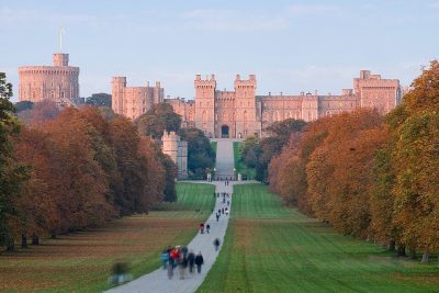 CastleWindsor Castle5.6 km away2
 Big drawTheme parkLegoland Windsor8.7 km away · 2.3M visitors a year (2024)3
 Historic house · National TrustCliveden House7 km away4
 Historic houseFrogmore House6.6 km away5
 Garden · National TrustRunnymede11 km away6
 Historic houseCumberland Lodge11 km away7
 GardenFrogmore Estate6.6 km away8
 MuseumBattle of Britain Bunker - RAF Uxbridge9.1 km away
Within 15 km, close and well known first. Numbers match the map.
Questions people have about Stoke Poges Memorial Gardens
Where is Stoke Poges Memorial Gardens?
Stoke Poges Memorial Gardens is 100 m south of Stoke Poges, Buckinghamshire.
What is Stoke Poges Memorial Gardens?
Garden in Stoke Poges, Buckinghamshire, England, UK.
When is the best time to visit Stoke Poges Memorial Gardens?
May to September are the warmest months in Stoke Poges, with afternoon highs of 17–23°C (Met Office 1991–2020 averages).
Is Stoke Poges Memorial Gardens a listed building?
Yes: Grade I listed park and garden.
What else is there to see near Stoke Poges Memorial Gardens?
Within 15 km: Windsor Castle (5.6 km), Legoland Windsor (8.7 km), Cliveden House (7 km) and Frogmore House (6.6 km).
Places: OpenStreetMap (© OpenStreetMap contributors, Open Database Licence) and Wikidata (CC0), placed in the ONS 2022 built-up area (Open Government Licence v3.0). Visitor counts are the latest Wikidata gives, with their year.
Photos: each place’s Wikidata image, from Wikimedia Commons under the licence below (our copy, resized).
Photo credits (9)
- Stoke Poges Memorial Gardens: Gill Griffin, CC BY 2.0, Wikimedia Commons
- Windsor Castle: Diliff, CC BY 2.5, Wikimedia Commons
- Legoland Windsor: Rob Young profile, CC BY 2.0, Wikimedia Commons
- Cliveden House: Antony McCallum. The original uploader was Wyrdlight at English Wikipedia., CC BY 3.0, Wikimedia Commons
- Frogmore House: Gill Hicks, CC BY-SA 2.0, Wikimedia Commons
- Runnymede: Wyrdlight, CC BY 3.0, Wikimedia Commons
- Cumberland Lodge: The original uploader was Jadriaen at English Wikipedia., CC BY-SA 2.5, Wikimedia Commons
- Frogmore Estate: Karen Roe from Bury St Edmunds, Suffolk, UK, CC BY 2.0, Wikimedia Commons
- Battle of Britain Bunker - RAF Uxbridge: Danielstirland at English Wikipedia, CC0, Wikimedia Commons
Contains public sector information licensed under the Open Government Licence v3.0. Contains HM Land Registry data © Crown copyright and database right 2026. Contains OS data © Crown copyright and database right 2026 (ONS boundaries). Northern Ireland: Source: NISRA; contains Land & Property Services data and Ordnance Survey of Northern Ireland information, © Crown copyright, licensed under the Open Government Licence v3.0. Scotland: contains National Records of Scotland data, Registers of Scotland data and SEPA data, © Crown copyright / © SEPA 2025, licensed under the Open Government Licence v3.0.