Shakespeare's Schoolroom & Guildhall
In Stratford-upon-Avon stands Shakespeare's Schoolroom & Guildhall, a museum. 12 more places to visit are within 5 km. Our list goes on with Shakespeare's Birthplace, 400 m away.
Museum in Stratford-upon-Avon
Inside Stratford-upon-Avon
Shakespeare's Schoolroom & Guildhall is inside Stratford-upon-Avon’s built-up area, with 12 more places to visit within 5 km. Towns near it ↓
Written from OpenStreetMap, Wikidata, the ONS built-up areas and Met Office 1991–2020 averages.
Picking your season
Warmest in Stratford-upon-Avon are May to September, at 17–23°C.
Shakespeare's Schoolroom & Guildhall
Museum.
In Stratford-upon-Avon, inside the town’s built-up area.
- Type
- Museum
- Town
- in Stratford-upon-Avon
- Official site
- shakespearesschoolroom.org
Address and hours
- EntryA fee is charged
Its place on the map
Orange shows Shakespeare's Schoolroom & Guildhall; numbers mark the places near it.
© OpenStreetMap contributors · The dashed line is Stratford-upon-Avon’s built-up area. · ONS built-up area 2022
Staying near Shakespeare's Schoolroom & Guildhall
With 28,112 people, Stratford-upon-Avon is the largest of the 7. Pick a base: each town is a page of its own, with what else there is to see.
Stratford-upon-Avon
Tiddington
Clifford Chambers
Wilmcote
Compare the 7 towns
| Town | Where Shakespeare's Schoolroom & Guildhall is | People | Places to visit |
|---|---|---|---|
| Stratford-upon-Avon | It’s in town | 28,112 | 18 |
| Tiddington | 1.9 km northeast of it | 1,687 | 17 |
| Clifford Chambers | 2.2 km south of it | 449 | 12 |
| Wilmcote | 4.4 km northwest of it | 940 | 15 |
| Welford-on-Avon | 4.8 km southwest of it | 1,692 | 11 |
| Snitterfield | 4.8 km north of it | 1,055 | 16 |
| Binton | 4.9 km west of it | 373 | 9 |
While you are near Shakespeare's Schoolroom & Guildhall
3 historic houses, 2 gardens and a castle are among the 39 within 15 km.
 Historic houseShakespeare's Birthplace400 m away2
 CastleWarwick Castle13 km away3
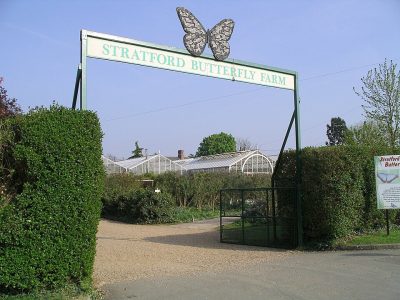 ZooStratford Butterfly Farm500 m away4
 Historic house · National TrustCharlecote Park5.9 km away5
 GardenMary Arden's Farm5 km away6Historic houseHistoric house · National TrustCoughton Court13 km away7GardenGarden · National TrustHidcote Manor Garden12 km away8
 MuseumStratford Armouries4.3 km away
Within 15 km, close and well known first. Numbers match the map.
Questions people have about Shakespeare's Schoolroom & Guildhall
Where is Shakespeare's Schoolroom & Guildhall?
Shakespeare's Schoolroom & Guildhall is in Stratford-upon-Avon, Warwickshire, inside the town’s built-up area.
What is Shakespeare's Schoolroom & Guildhall?
Museum.
When is the best time to visit Shakespeare's Schoolroom & Guildhall?
May to September are the warmest months in Stratford-upon-Avon, with afternoon highs of 17–23°C (Met Office 1991–2020 averages).
What else is there to see near Shakespeare's Schoolroom & Guildhall?
Within 15 km: Shakespeare's Birthplace (400 m), Warwick Castle (13 km), Stratford Butterfly Farm (500 m) and Charlecote Park (5.9 km).
Places: OpenStreetMap (© OpenStreetMap contributors, Open Database Licence) and Wikidata (CC0), placed in the ONS 2022 built-up area (Open Government Licence v3.0). Visitor counts are the latest Wikidata gives, with their year.
Photos: each place’s Wikidata image, from Wikimedia Commons under the licence below (our copy, resized).
Photo credits (6)
- Shakespeare's Birthplace: Public domain, Wikimedia Commons
- Warwick Castle: DeFacto, CC BY-SA 4.0, Wikimedia Commons
- Stratford Butterfly Farm: Snowmanradio, CC BY-SA 3.0, Wikimedia Commons
- Charlecote Park: David Dixon, CC BY-SA 2.0, Wikimedia Commons
- Mary Arden's Farm: Elliott Brown, CC BY 2.0, Wikimedia Commons
- Stratford Armouries: Bazmasta, Public domain, Wikimedia Commons
Contains public sector information licensed under the Open Government Licence v3.0. Contains HM Land Registry data © Crown copyright and database right 2026. Contains OS data © Crown copyright and database right 2026 (ONS boundaries). Northern Ireland: Source: NISRA; contains Land & Property Services data and Ordnance Survey of Northern Ireland information, © Crown copyright, licensed under the Open Government Licence v3.0. Scotland: contains National Records of Scotland data, Registers of Scotland data and SEPA data, © Crown copyright / © SEPA 2025, licensed under the Open Government Licence v3.0.