
SAW - The Ride
SAW - The Ride is a steel Euro Fighter roller coaster. Look for it within Staines-upon-Thames’ built-up area. A short trip away is Thorpe Park, 100 m off, the first of 129 within 15 km.
Attraction in Staines-upon-Thames
Inside Staines-upon-Thames
SAW - The Ride is inside Staines-upon-Thames’ built-up area, with 20 more places to visit within 5 km. Towns near it ↓
Written from OpenStreetMap, Wikidata, the ONS built-up areas and Met Office 1991–2020 averages.
Weather, month by month
The warmest stretch in Staines-upon-Thames is May to September, at 18–23°C in the afternoon.
SAW - The Ride
4 Wikipedia editions have an article on it.
- Type
- Attraction
- Wikipedias
- Covered in 4 languages
- Town
- in Staines-upon-Thames
- Official site
- thorpepark.com/explore/theme-park/rides/saw-the-ride
The essentials
Map of SAW - The Ride and nearby
Orange shows SAW - The Ride; numbers mark the places near it.
© OpenStreetMap contributors · The dashed line is Staines-upon-Thames’ built-up area. · ONS built-up area 2022
Nearby towns
Egham is the biggest of the 8 bases nearby (28,003 people). Start with its own town; the others follow by distance.
Staines-upon-Thames
Chertsey
Penton Hook
Thorpe
Compare the 8 towns
| Town | Where SAW - The Ride is | People | Places to visit |
|---|---|---|---|
| Staines-upon-Thames | It’s in town | 21,327 | 31 |
| Chertsey | 500 m south of it | 14,558 | 35 |
| Penton Hook | 700 m northeast of it | 404 | 23 |
| Thorpe | 1.2 km west of it | 1,226 | 28 |
| Laleham | 1.4 km northeast of it | 2,521 | 24 |
| Lyne | 1.8 km southwest of it | 1,202 | 24 |
| Virginia Water | 1.9 km west of it | 5,185 | 34 |
| Egham | 2.2 km northwest of it | 28,003 | 37 |
Worth adding to a visit
Choose from 129 places within 15 km, such as 4 attractions, a theme park and a castle.
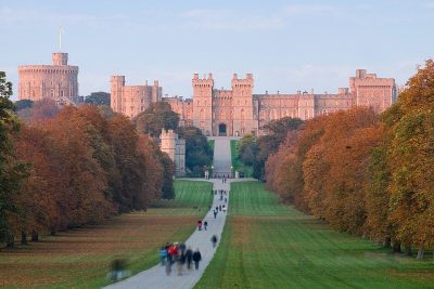 CastleWindsor Castle11 km away3
 Historic house · Historic Royal PalacesHampton Court Palace12 km away4
 Garden · National TrustRunnymede5.3 km away5
 AttractionColossus100 m away6
 AttractionHyperia100 m away7
 AttractionStealth400 m away8
 AttractionThe Swarm400 m away
Within 15 km, close and well known first. Numbers match the map.
Visiting SAW - The Ride: the answers
Where is SAW - The Ride?
SAW - The Ride is in Staines-upon-Thames, Surrey, inside the town’s built-up area.
What is SAW - The Ride?
Steel Euro Fighter roller coaster.
When is the best time to visit SAW - The Ride?
May to September are the warmest months in Staines-upon-Thames, with afternoon highs of 18–23°C (Met Office 1991–2020 averages).
What else is there to see near SAW - The Ride?
Within 15 km: Thorpe Park (100 m), Windsor Castle (11 km), Hampton Court Palace (12 km) and Runnymede (5.3 km).
Places: OpenStreetMap (© OpenStreetMap contributors, Open Database Licence) and Wikidata (CC0), placed in the ONS 2022 built-up area (Open Government Licence v3.0). Visitor counts are the latest Wikidata gives, with their year.
Photos: each place’s Wikidata image, from Wikimedia Commons under the licence below (our copy, resized).
Photo credits (8)
- SAW - The Ride: Stefan Scheer, CC BY-SA 3.0, Wikimedia Commons
- Windsor Castle: Diliff, CC BY 2.5, Wikimedia Commons
- Hampton Court Palace: Ricardalovesmonuments, CC BY-SA 4.0, Wikimedia Commons
- Runnymede: Wyrdlight, CC BY 3.0, Wikimedia Commons
- Colossus: Stefan Scheer, CC BY-SA 3.0, Wikimedia Commons
- Hyperia: Suntooooth, CC BY-SA 4.0, Wikimedia Commons
- Stealth: Stefan Scheer, CC BY 2.5, Wikimedia Commons
- The Swarm: Mitchellh1234, CC BY-SA 3.0, Wikimedia Commons
Contains public sector information licensed under the Open Government Licence v3.0. Contains HM Land Registry data © Crown copyright and database right 2026. Contains OS data © Crown copyright and database right 2026 (ONS boundaries). Northern Ireland: Source: NISRA; contains Land & Property Services data and Ordnance Survey of Northern Ireland information, © Crown copyright, licensed under the Open Government Licence v3.0. Scotland: contains National Records of Scotland data, Registers of Scotland data and SEPA data, © Crown copyright / © SEPA 2025, licensed under the Open Government Licence v3.0.