Letocetum Roman Baths and Museum
Visitors find Letocetum Roman Baths and Museum, ruins, 1.2 km southwest of Lichfield. Care of the site is provided by English Heritage. There are 29 more places to see within 15 km, beginning with Lichfield Cathedral (3.6 km).
Ruins near Lichfield
Just outside Lichfield
Letocetum Roman Baths and Museum is 1.2 km southwest of Lichfield. Towns near it ↓
Cared for by English Heritage
One of the places English Heritage looks after; members usually get in free. About ↓
Written from OpenStreetMap, Wikidata, the ONS built-up areas and Met Office 1991–2020 averages.
Picking your season
Afternoons in Lichfield reach 19–22°C from June to September.
Letocetum Roman Baths and Museum
Ruins.
It is run by English Heritage.
- Type
- Ruins
- Run by
- English Heritage
- Town
- 1.2 km southwest of Lichfield
- Official site
- pastscape.org.uk/hob.aspx?hob_id=304404
Letocetum Roman Baths and Museum on the map
Orange is Letocetum Roman Baths and Museum; numbered in green, the places near it.
© OpenStreetMap contributors · ONS built-up area 2022
Nearby towns
The biggest base of the 8 is Lichfield (32,586 people). Its own town leads; the rest list it too, closest first.
Lichfield
Shenstone
Hammerwich
Burntwood
Compare the 8 towns
| Town | Where Letocetum Roman Baths and Museum is | People | Places to visit |
|---|---|---|---|
| Lichfield | 1.2 km northeast of it | 32,586 | 8 |
| Shenstone | 1.7 km southeast of it | 2,196 | 9 |
| Hammerwich | 2.7 km west of it | 668 | 10 |
| Burntwood | 2.8 km northwest of it | 27,891 | 12 |
| Stonnall | 3 km southwest of it | 1,340 | 6 |
| Weeford | 3.2 km east of it | 972 | 9 |
| Brownhills | 3.6 km west of it | 21,238 | 10 |
| Whittington | 4.9 km east of it | 2,477 | 8 |
What else is near Letocetum Roman Baths and Museum
3 museums, a cathedral and a castle are among the 29 within 15 km.
 CathedralLichfield Cathedral3.6 km away2
 MuseumThe Samuel Johnson Birthplace Museum3.5 km away · 16K visitors a year3
 CastleTamworth Castle11 km away4
 Historic houseErasmus Darwin House3.5 km away5
 ZooDrayton Manor Zoo11 km away6
 Art galleryThe New Art Gallery12 km away7
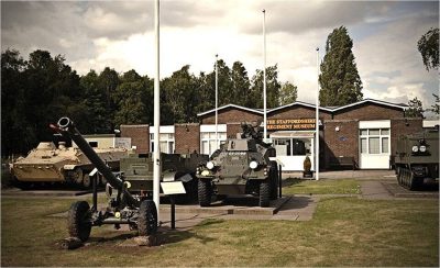 MuseumStaffordshire Regiment Museum5.3 km away8
 MuseumLichfield Heritage Centre3.6 km away
Within 15 km, close and well known first. Numbers match the map.
Asked about Letocetum Roman Baths and Museum
Where is Letocetum Roman Baths and Museum?
Letocetum Roman Baths and Museum is 1.2 km southwest of Lichfield, Staffordshire.
What is Letocetum Roman Baths and Museum?
Ruins.
Who runs Letocetum Roman Baths and Museum?
English Heritage, so members usually get in free; check opening times before you go.
When is the best time to visit Letocetum Roman Baths and Museum?
June to September are the warmest months in Lichfield, with afternoon highs of 19–22°C (Met Office 1991–2020 averages).
What else is there to see near Letocetum Roman Baths and Museum?
Within 15 km: Lichfield Cathedral (3.6 km), The Samuel Johnson Birthplace Museum (3.5 km), Tamworth Castle (11 km) and Erasmus Darwin House (3.5 km).
Places: OpenStreetMap (© OpenStreetMap contributors, Open Database Licence) and Wikidata (CC0), placed in the ONS 2022 built-up area (Open Government Licence v3.0). Visitor counts are the latest Wikidata gives, with their year.
Photos: each place’s Wikidata image, from Wikimedia Commons under the licence below (our copy, resized).
Photo credits (8)
- Lichfield Cathedral: Bs0u10e01, CC BY-SA 3.0, Wikimedia Commons
- The Samuel Johnson Birthplace Museum: Bs0u10e01, CC BY 3.0, Wikimedia Commons
- Tamworth Castle: Stan, CC BY-SA 2.0, Wikimedia Commons
- Erasmus Darwin House: Bs0u10e01, CC BY-SA 3.0, Wikimedia Commons
- Drayton Manor Zoo: Steve Daniels, CC BY-SA 2.0, Wikimedia Commons
- The New Art Gallery: Popsracer at English Wikipedia, CC BY-SA 3.0, Wikimedia Commons
- Staffordshire Regiment Museum: WarMagician at English Wikipedia, CC BY 3.0, Wikimedia Commons
- Lichfield Heritage Centre: Bs0u10e01, CC BY 3.0, Wikimedia Commons
Contains public sector information licensed under the Open Government Licence v3.0. Contains HM Land Registry data © Crown copyright and database right 2026. Contains OS data © Crown copyright and database right 2026 (ONS boundaries). Northern Ireland: Source: NISRA; contains Land & Property Services data and Ordnance Survey of Northern Ireland information, © Crown copyright, licensed under the Open Government Licence v3.0. Scotland: contains National Records of Scotland data, Registers of Scotland data and SEPA data, © Crown copyright / © SEPA 2025, licensed under the Open Government Licence v3.0.