
Hole Park Gardens
Hole Park Gardens is a country house. Look for it 1.3 km northwest of Rolvenden. It is protected as a Grade II listed building.
Garden near Rolvenden
Just outside Rolvenden
Hole Park Gardens is 1.3 km northwest of Rolvenden. Towns near it ↓
Grade II listed building
On the official list of protected heritage; Rolvenden has 45 listed buildings in all, on its History page. About ↓
Written from OpenStreetMap, Wikidata, the ONS built-up areas and Met Office 1991–2020 averages.
Picking your season
The warmest stretch in Rolvenden is May to September, at 17–22°C in the afternoon.
Hole Park Gardens
Its story is told in 2 languages on Wikipedia. Add Bodiam Castle, 8.3 km away, to a visit; it leads 27 places within 15 km.
- Type
- Garden
- Listed
- Grade II listed building
- Wikipedias
- Covered in 2 languages
- Town
- 1.3 km northwest of Rolvenden
- Official site
- holepark.com
Around Hole Park Gardens, mapped
Hole Park Gardens sits at the orange dot; the numbered ones are listed below.
© OpenStreetMap contributors · ONS built-up area 2022
Which town is nearest
Of these 6 towns, the largest is Tenterden (7,775 people). These are the towns that list it, beginning with its own.
Rolvenden
Benenden
Rolvenden Layne
Tenterden
While you are near Hole Park Gardens
3 gardens, 2 castles and a heritage railway are among the 27 within 15 km.
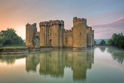 Castle · National TrustBodiam Castle8.3 km away2
 Garden · National TrustSissinghurst Castle and Garden6.3 km away3Heritage railwayHeritage railwayKent and East Sussex Railway5.1 km away4
 Castle · National TrustScotney Castle15 km away5
 GardenGreat Dixter7.5 km away6
 Historic house · National TrustSmallhythe Place6.6 km away7
 GardenBedgebury National Pinetum11 km away8
 FortRoyal Military Canal14 km away
Within 15 km, close and well known first. Numbers match the map.
Good to know about Hole Park Gardens
Where is Hole Park Gardens?
Hole Park Gardens is 1.3 km northwest of Rolvenden, Kent.
What is Hole Park Gardens?
Country house in Kent, England, UK.
When is the best time to visit Hole Park Gardens?
May to September are the warmest months in Rolvenden, with afternoon highs of 17–22°C (Met Office 1991–2020 averages).
Is Hole Park Gardens a listed building?
Yes: Grade II listed building.
What else is there to see near Hole Park Gardens?
Within 15 km: Bodiam Castle (8.3 km), Sissinghurst Castle and Garden (6.3 km), Kent and East Sussex Railway (5.1 km) and Scotney Castle (15 km).
Places: OpenStreetMap (© OpenStreetMap contributors, Open Database Licence) and Wikidata (CC0), placed in the ONS 2022 built-up area (Open Government Licence v3.0). Visitor counts are the latest Wikidata gives, with their year.
Photos: each place’s Wikidata image, from Wikimedia Commons under the licence below (our copy, resized).
Photo credits (8)
- Hole Park Gardens: Oast House Archive, CC BY-SA 2.0, Wikimedia Commons
- Bodiam Castle: Antony McCallum, CC BY-SA 3.0, Wikimedia Commons
- Sissinghurst Castle and Garden: Hans Bernhard (Schnobby), CC BY-SA 3.0, Wikimedia Commons
- Scotney Castle: Berit from Redhill/Surrey, UK, CC BY 2.0, Wikimedia Commons
- Great Dixter: Miles Berry, CC BY-SA 2.0, Wikimedia Commons
- Smallhythe Place: Tony Hisgett from Birmingham, UK, CC BY 2.0, Wikimedia Commons
- Bedgebury National Pinetum: Colin Smith, CC BY-SA 2.0, Wikimedia Commons
- Royal Military Canal: Sebastian Ballard, CC BY-SA 2.0, Wikimedia Commons
Contains public sector information licensed under the Open Government Licence v3.0. Contains HM Land Registry data © Crown copyright and database right 2026. Contains OS data © Crown copyright and database right 2026 (ONS boundaries). Northern Ireland: Source: NISRA; contains Land & Property Services data and Ordnance Survey of Northern Ireland information, © Crown copyright, licensed under the Open Government Licence v3.0. Scotland: contains National Records of Scotland data, Registers of Scotland data and SEPA data, © Crown copyright / © SEPA 2025, licensed under the Open Government Licence v3.0.