
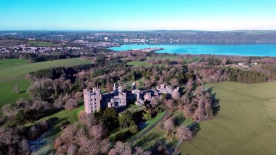
Castell Aberlleiniog
Castell Aberlleiniog is a grade II* listed building. Its setting is 400 m east of Llangoed. Add Castell Biwmares / Beaumaris Castle, 3.2 km away, to a visit; it leads 25 places within 15 km.
Castle near Llangoed
One of the best-known places to visit in England, Scotland, Wales and Northern Ireland
#578 of the 8,556 museums, castles, gardens and other attractions we list, by how widely it is covered (12 Wikipedias). About ↓
Just outside Llangoed
Castell Aberlleiniog is 400 m east of Llangoed. Towns near it ↓
Grade II* listed building
On the official list of protected heritage; Llangoed has 4 listed buildings in all, on its History page. About ↓
Written from OpenStreetMap, Wikidata, the ONS built-up areas and Met Office 1991–2020 averages.
Which month to go
The warmest afternoons in Llangoed run June to September, at 17–19°C.
Castell Aberlleiniog
12 Wikipedia editions have an article on it.
- Type
- Castle
- Listed
- Grade II* listed building
- Wikipedias
- Covered in 12 languages
- Town
- 400 m east of Llangoed
Mapping Castell Aberlleiniog
Orange is Castell Aberlleiniog; numbered in green, the places near it.
© OpenStreetMap contributors · ONS built-up area 2022
Where people come from
Of these 8 towns, the largest is Bangor (16,994 people). Its home town tops the list; the rest follow by distance.
Llangoed
Beaumaris
Llanddona
Llandegfan
Compare the 8 towns
| Town | Where Castell Aberlleiniog is | People | Places to visit |
|---|---|---|---|
| Llangoed | 400 m west of it | 572 | 6 |
| Beaumaris | 3.1 km south of it | 1,120 | 14 |
| Llanddona | 3.8 km west of it | 642 | 4 |
| Llandegfan | 7.1 km southwest of it | 999 | 15 |
| Llanfairfechan | 8.1 km southeast of it | 3,547 | 2 |
| Llandygai | 8.5 km south of it | 331 | 13 |
| Bangor | 9 km southwest of it | 16,994 | 19 |
| Menai Bridge | 9.3 km southwest of it | 3,045 | 16 |
More to see nearby
Our list has 25 more within 15 km, among them 2 castles, 2 piers and a cathedral.
 Castle · CadwCastell Biwmares / Beaumaris Castle3.2 km away2
 CathedralBangor Cathedral8.1 km away3
 Castle · National TrustPenrhyn Castle7.5 km away4
 PierGarth Pier6.9 km away5
 PierBeaumaris Pier3.6 km away6
 GardenTreborth Botanic Garden11 km away7
 Historic housePlas Cadnant8.5 km away8
 MuseumThomas Telford Centre9.7 km away
Within 15 km, close and well known first. Numbers match the map.
Planning a visit to Castell Aberlleiniog
Where is Castell Aberlleiniog?
Castell Aberlleiniog is 400 m east of Llangoed, Gwynedd.
What is Castell Aberlleiniog?
Grade II* listed building in Anglesey.
When is the best time to visit Castell Aberlleiniog?
June to September are the warmest months in Llangoed, with afternoon highs of 17–19°C (Met Office 1991–2020 averages).
Is Castell Aberlleiniog a listed building?
Yes: Grade II* listed building.
What else is there to see near Castell Aberlleiniog?
Within 15 km: Castell Biwmares / Beaumaris Castle (3.2 km), Bangor Cathedral (8.1 km), Penrhyn Castle (7.5 km) and Garth Pier (6.9 km).
Places: OpenStreetMap (© OpenStreetMap contributors, Open Database Licence) and Wikidata (CC0), placed in the ONS 2022 built-up area (Open Government Licence v3.0). Visitor counts are the latest Wikidata gives, with their year.
Photos: each place’s Wikidata image, from Wikimedia Commons under the licence below (our copy, resized).
Photo credits (9)
- Castell Aberlleiniog: Stephen Elwyn RODDICK, CC BY-SA 2.0, Wikimedia Commons
- Castell Biwmares / Beaumaris Castle: Llywelyn2000, CC BY-SA 4.0, Wikimedia Commons
- Bangor Cathedral: Denis Egan from Bangor, Gwynedd, North Wales, CC BY 2.0, Wikimedia Commons
- Penrhyn Castle: Llywelyn2000, CC BY-SA 4.0, Wikimedia Commons
- Garth Pier: Reading Tom from Reading, UK, CC BY 2.0, Wikimedia Commons
- Beaumaris Pier: David C Williams, CC BY-SA 2.0, Wikimedia Commons
- Treborth Botanic Garden: CV1958 (Colin Viney), CC BY-SA 4.0, Wikimedia Commons
- Plas Cadnant: Talsarnau Times, CC BY-SA 3.0, Wikimedia Commons
- Thomas Telford Centre: Warrenkovach, CC BY-SA 4.0, Wikimedia Commons
Contains public sector information licensed under the Open Government Licence v3.0. Contains HM Land Registry data © Crown copyright and database right 2026. Contains OS data © Crown copyright and database right 2026 (ONS boundaries). Northern Ireland: Source: NISRA; contains Land & Property Services data and Ordnance Survey of Northern Ireland information, © Crown copyright, licensed under the Open Government Licence v3.0. Scotland: contains National Records of Scotland data, Registers of Scotland data and SEPA data, © Crown copyright / © SEPA 2025, licensed under the Open Government Licence v3.0.